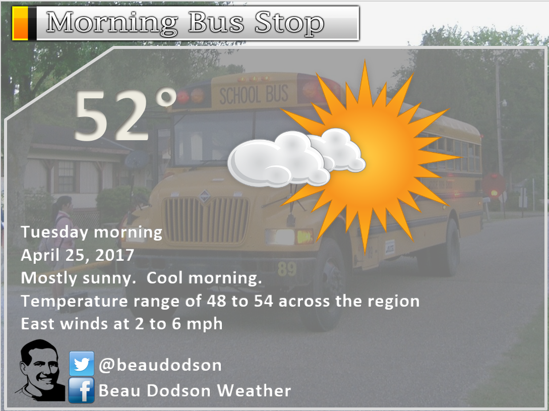
Tuesday Update: The main concern is going to be strong thunderstorms Wednesday afternoon and Wednesday night.
Today: Nice day. A few passing clouds. Very warm for this time of the year. High temperatures from 76 to 82 degrees. Winds will be from the south at 10 to 30 mph.
Not anticipating any significant weather tonight. A 10% for a thunderstorm over 2 am for southeast Missouri. Mild tonight, as well.
Wednesday:
Warm and windy on Wednesday with highs in the upper 70’s to lower 80’s. Clouds may thicken as the day wears on (esp western half of the region).
Thunderstorms are forecast to develop by Wednesday afternoon and especially Wednesday evening/night.
The storms will first form over Missouri and Arkansas. Probably some mixed mode of supercells becoming a line of storms. Some of the storms will probably bow out a bit. Line segments possible.
A few storms could produce large hail and strong winds. There is a risk for isolated tornadoes, as well. Lightning and heavy downpours are a good bet.
Storms will move east and northeast at 40 mph.
The greatest risk zone will be over southeast Missouri and southwest Illinois. This is where the dynamics will be the strongest. Areas to the east of there could also experience some strong storms, but the severe weather risk may diminish rapidly once we push deeper into the evening.
There is an 80% for a tornado or severe thunderstorm watch for portions of southeast Missouri and southwest Illinois on Wednesday afternoon or night.
There is a 60% for a tornado or severe thunderstorm watch for southeast Illinois, western Kentucky, and western Tennessee on Wednesday afternoon or night.
There is a 30% for a severe thunderstorm watch for the Pennyrile area of western Kentucky Wednesday night.
A watch means to monitor updates. A warning means to seek shelter.
Showers and storms will end west to east late Wednesday night/Thursday morning.
Most of Thursday should remain dry. Perhaps a remaining shower early in the morning for southeast Illinois and the Pennyrile area of western Kentucky. A bit cooler on Thursday with highs mostly in the 60’s.
Heavy rain event this weekend:
Shower and thunderstorm chances begin to increase Thursday night and will be with us through Sunday night.
Perhaps highest coverage will be Friday night and Sunday afternoon/night.
If you have plans on Friday, Saturday, or Sunday, then you will want to monitor updated forecasts. The trend has been wetter.
Several inches of rain may fall between now and Monday. I would not be surprised if once again some counties top four inches of rain. The area picked up 0.50″ to 4.5″ last weekend. Add more to those totals and you could have some creek and river flooding.
The flood potential will need to be monitored.
Some strong storms are possible, as well. The greatest risk for intense storms will probably occur Sunday afternoon and night.
We have returned to our active pattern. Same pattern we have been in for several months.
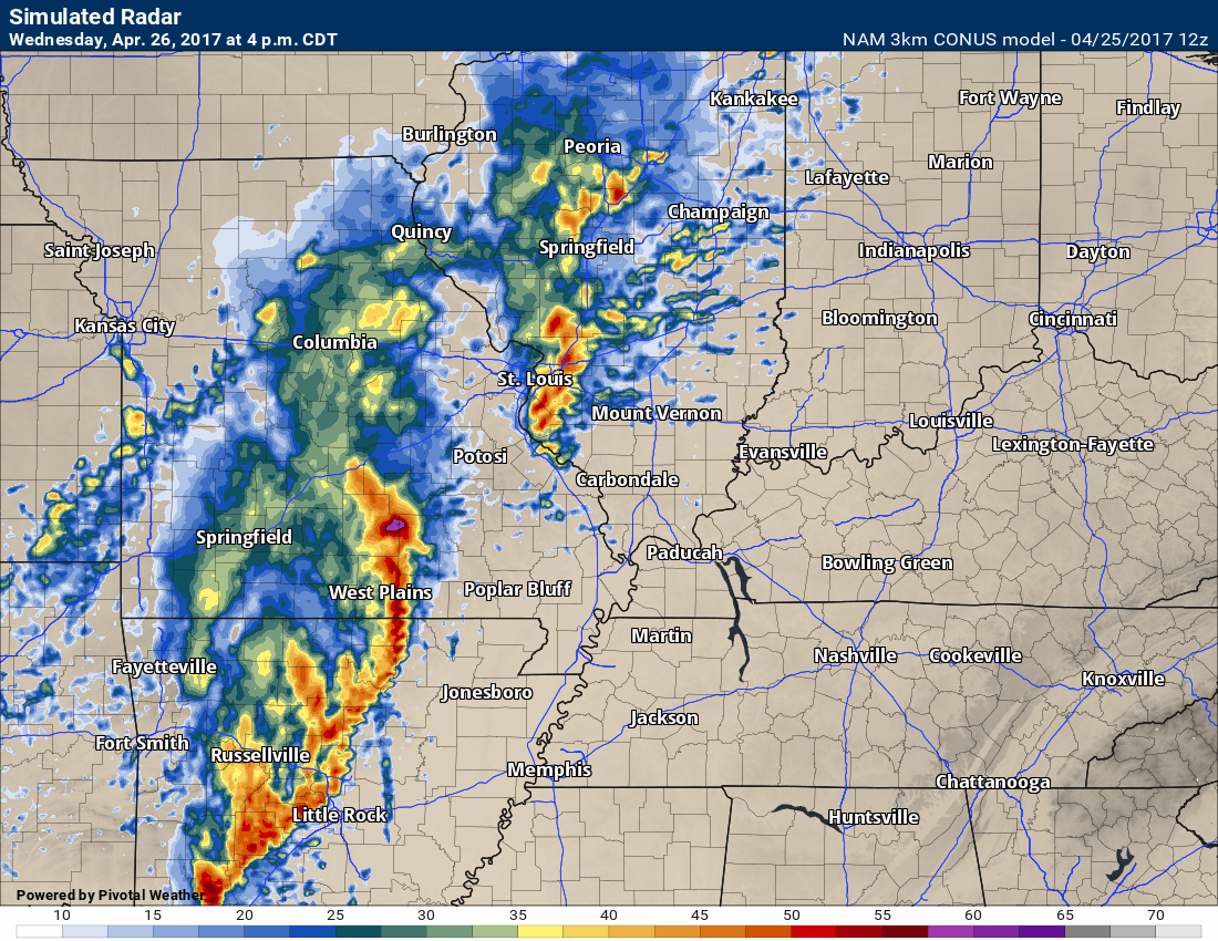
4 PM Wednesday future-cast radar. What radar might look like. These storms will move east/northeast through the evening hours.
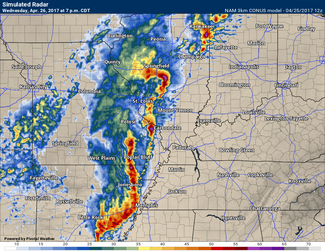
7 PM future-cast radar
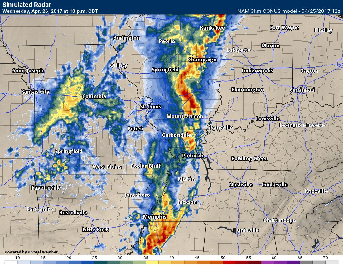
10 PM Future-cast radar
The line will weaken as it moves further east


This forecast update covers far southern Illinois, far southeast Missouri, and far western Kentucky. See the coverage map on the right side of the blog
April 24, 2017
Monday Night Forecast Details:
Forecast: Clear and cool. Perhaps late night patchy fog.
Temperatures: MO ~ 48 to 54 IL ~ 48 to 54 KY ~ 50 to 54 TN ~ 50 to 55
Winds: Winds becoming east and southeast at 0 to 5 mph.
My confidence in the forecast verifying: High. This forecast should verify..
What impacts are anticipated from the weather? Perhaps some late night fog. Otherwise, no impacts.
Is severe weather expected? No
The NWS defines severe weather as 58 mph winds or great, 1″ hail or larger, and/or tornadoes
What is the chance of precipitation? MO ~ 0% IL ~ 0% KY ~ 0% TN ~ 0%
Coverage of precipitation: None.
Should I cancel my outdoor plans? No
.
April 25, 2017
Tuesday Forecast Details
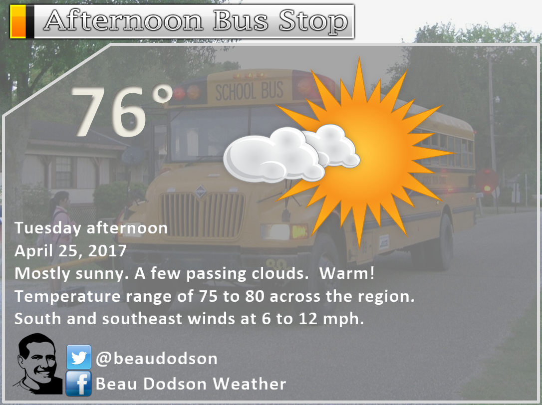
Forecast: Mostly sunny. Mild. Another nice day anticipated. Warmer.
Temperatures: MO ~ 75 to 80 IL ~ 75 to 80 KY ~ 75 to 80 TN ~ 75 to 80
Winds: South and southeast at 6 to 12 mph with gusts to 18 mph.
What impacts are anticipated from the weather? None
My confidence in the forecast verifying: High. This forecast should verify.
Is severe weather expected? No
The NWS defines severe weather as 58 mph winds or great, 1″ hail or larger, and/or tornadoes
What is the chance of precipitation? MO ~ 0% IL ~ 0% KY ~ 0% TN ~ 0%
Coverage of precipitation: None
Should I cancel my outdoor plans? No
Sunrise will be at 6:07 a.m. and sunset will be at 7:37 p.m.
Tuesday Night Forecast Details:
Forecast: Breezy. Partly cloudy. A 20% for a late night thunderstorm over southeast Missouri and southwest Illinois. Most areas will remain dry.
Temperatures: MO ~ 58 to 64 IL ~ 58 to 64 KY ~ 58 to 64 TN ~ 60 to 65
Winds: South at 7 to 14 mph with gusts over 25 mph
My confidence in the forecast verifying: Medium. Some adjustments are possible.
What impacts are anticipated from the weather? A few late night storms could produce lightning. Wet roadways.
Is severe weather expected? No
The NWS defines severe weather as 58 mph winds or great, 1″ hail or larger, and/or tornadoes
What is the chance of precipitation? MO ~ 20% IL ~ 20% KY ~ 10% TN ~ 10%
Coverage of precipitation: Perhaps isolated late at night over our western counties (SE MO/SW IL)
Should I cancel my outdoor plans? No
.
April 26, 2017
Wednesday Forecast: Partly to mostly cloudy. Scattered storms possible, mainly during the afternoon hours. Some storms could be strong late in the day. Breezy. Temperatures will be several degrees warmer if we have some sunshine.
Temperatures: MO ~ 74 to 78 IL ~ 74 to 78 KY ~ 74 to 78 TN ~ 74 to 78
Winds: South at 8 to 16 mph with gusts to 25 mph
What impacts are anticipated from the weather? Lightning. Downpours. Monitor severe weather risk late in the day.
My confidence in the forecast verifying: Medium. Some adjustments are possible.
Is severe weather expected? Some intense storms possible late in the afternoon.
The NWS defines severe weather as 58 mph winds or great, 1″ hail or larger, and/or tornadoes
What is the chance of precipitation? MO ~ 50% IL ~ 40% KY ~ 30% TN ~ 30%
Coverage of precipitation: Scattered (mainly during the afternoon hours)
Should I cancel my outdoor plans? Monitor radars
Sunrise will be at 6:04 a.m. and sunset will be at 7:39 p.m.
Wednesday Night Forecast Details:
Forecast: Cloudy. Showers and thunderstorms likely. Some storms could be strong with high winds and hail (mainly southeast Missouri). Heavy downpours possible. Gusty winds.
Temperatures: MO ~ 48 to 54 IL ~ 48 to 54 KY ~ 50 to 55 TN ~ 50 to 55
Winds: South and southwest becoming west and northwest at 10 to 20 mph.
My confidence in the forecast verifying: Medium. Some adjustments are possible.
What impacts are anticipated from the weather? Wet roadways. Lightning. Heavy downpours. A few storms could be intense.
Is severe weather expected? Perhaps isolated severe reports for southeast Missouri. Small risk elsewhere.
The NWS defines severe weather as 58 mph winds or great, 1″ hail or larger, and/or tornadoes
What is the chance of precipitation? MO ~ 90% IL ~ 90% KY ~ 90% TN ~ 90%
Coverage of precipitation: Widespread as the night wears on.
Should I cancel my outdoor plans? Have a plan B.
.
April 27, 2017
Thursday Forecast Details
Forecast: Partly cloudy. A morning shower possible. Cooler. Less humid.
Temperatures: MO ~ 60 to 65 IL ~ 60 to 65 KY ~ 60 to 65 TN ~ 60 to 65
Winds: West and northwest winds at 5 to 10 mph with gusts to 14 mph
What impacts are anticipated from the weather? None
My confidence in the forecast verifying: Medium. Some adjustments are possible.
Is severe weather expected? No
The NWS defines severe weather as 58 mph winds or great, 1″ hail or larger, and/or tornadoes
What is the chance of precipitation? MO ~ 20% IL ~ 20% KY ~ 30% TN ~ 20%
Coverage of precipitation: Scattered
Should I cancel my outdoor plans? No
Sunrise will be at 6:02 a.m. and sunset will be at 7:40 p.m.
Thursday Night Forecast Details:
Forecast: Partly cloudy. A slight chance for thunderstorms after 1 am.
Temperatures: MO ~ 54 to 58 IL ~ 54 to 58 KY ~ 54 to 58 TN ~ 54 to 58
Winds: South and southeast at 5 to 10 mph with gusts to 15 mph
My confidence in the forecast verifying: Low. Significant adjustments are possible.
What impacts are anticipated from the weather? Scattered late night storms possible. Best chance would be southeast Missouri.
Is severe weather expected? No
The NWS defines severe weather as 58 mph winds or great, 1″ hail or larger, and/or tornadoes
What is the chance of precipitation? MO ~ 30% IL ~ 20% KY ~ 20% TN ~ 20%
Coverage of precipitation: Isolated to scattered late at night.
Should I cancel my outdoor plans? No
.
April 28, 2017
Friday Forecast Details
Forecast: Partly cloudy. Thunderstorms possible. Warm.
Temperatures: MO ~ 75 to 80 IL ~ 74 to 78 KY ~ 75 to 80 TN ~ 75 to 80
Winds: South and southeast winds at 6 to 12 mph with gusts to 20 mph
What impacts are anticipated from the weather? Lightning. Wet roadways.
My confidence in the forecast verifying: Low. Significant adjustments are possible.
Is severe weather expected? Monitor updates
The NWS defines severe weather as 58 mph winds or great, 1″ hail or larger, and/or tornadoes
What is the chance of precipitation? MO ~ 40% IL ~ 40% KY ~ 30% TN ~ 30%
Coverage of precipitation: Scattered. Some data shows widespread. Mixed signals.
Should I cancel my outdoor plans? No, but monitor updates
Sunrise will be at 6:02 a.m. and sunset will be at 7:41 p.m.
Friday Night Forecast Details:
Forecast: Becoming cloudy. Showers and thunderstorms possible. Locally heavy downpours possible.
Temperatures: MO ~ 62 to 66 IL ~ 62 to 66 KY ~ 62 to 66 TN ~ 62 to 66
Winds: South winds at 6 to 12 mph
My confidence in the forecast verifying: Low. Significant adjustments are possible.
What impacts are anticipated from the weather? Lightning. Gusty winds. Wet roadways.
Is severe weather expected? Not at this time, but monitor updates.
The NWS defines severe weather as 58 mph winds or great, 1″ hail or larger, and/or tornadoes
What is the chance of precipitation? MO ~ 50% IL ~ 50% KY ~ 50% TN ~ 50%
Coverage of precipitation: Scattered.
Should I cancel my outdoor plans? Monitor updated forecasts. Some storms are possible Friday night.
.
April 29, 2017
Saturday Forecast Details
Forecast: Partly sunny. A 50% for morning showers and thunderstorms. A 40% for afternoon showers and thunderstorms. Mild. Breezy, at times.
Temperatures: MO ~ 76 to 82 IL ~ 76 to 82 KY ~ 76 to 82 TN ~ 76 yo 82
Winds: South winds at 6 to 12 mph with gusts to 20 mph
What impacts are anticipated from the weather? Lightning. Wet roadways.
My confidence in the forecast verifying: Low. Significant adjustments are possible.
Is severe weather expected? Monitor updates.
The NWS defines severe weather as 58 mph winds or great, 1″ hail or larger, and/or tornadoes
What is the chance of precipitation? MO ~ 50% IL ~ 50% KY ~ 50% TN ~ 50%
Coverage of precipitation: Scattered.
Should I cancel my outdoor plans? No, but monitor radars.
Sunrise will be at 6:00 a.m. and sunset will be at 7:42 p.m.
Saturday Night Forecast Details:
Forecast: Partly to mostly cloudy. Warm. A shower or thunderstorm possible.
Temperatures: MO ~ 65 to 70 IL ~ 65 to 70 KY ~ 65 to 70 TN ~ 65 to 70
Winds: South winds at 6 to 12 mph with gusts to 18 mph
My confidence in the forecast verifying: Low. Significant adjustments are possible.
What impacts are anticipated from the weather? Lightning. Gusty winds. Wet roadways.
Is severe weather expected? Not at this time, but monitor updates.
The NWS defines severe weather as 58 mph winds or great, 1″ hail or larger, and/or tornadoes
What is the chance of precipitation? MO ~ 40% IL ~ 40% KY ~ 40% TN ~ 40%
Coverage of precipitation: Scattered
Should I cancel my outdoor plans? No, but monitor updated forecasts.
.
A few scattered storms possible Sunday. Widespread showers and storms Sunday night. Heavy rain possible. Some storms could be intense on Sunday night, as well. Monitor updates.
Bus stop forecast
.
.

Don’t forget to check out the Southern Illinois Weather Observatory web-site for weather maps, tower cams, scanner feeds, radars, and much more! Click here

An explanation of what is happening in the atmosphere over the coming day

Severe thunderstorm outlook.
Remember that a severe thunderstorm is defined as a thunderstorm that produces 60 mph winds or higher, quarter size hail or larger, and/or a tornado.
Monday into Tuesday: Severe weather is not anticipated.
Tuesday night: A small risk for a thunderstorm late at night over southeast Missouri and southwest Illinois. Lightning would be the primary concern. Most of the region will remain dry.
Wednesday and Wednesday night: Scattered storms are possible on Wednesday afternoon. Thunderstorm activity will increase in intensity and coverage on Wednesday night. Some of the storms could produce high winds and hail. Frequent lightning, as well. Heavy rain likely. There is a risk for a few severe thunderstorms on Wednesday night. Monitor updates.
Thursday and Thursday night: Dry Thursday, but perhaps a storm after 2 am on Thursday night/Friday morning.
Friday into Friday night: A warm front will pass through the region. Some thunderstorms are possible. I can’t rule out strong storms.
Sunday into Monday: Scattered storms are possible on Sunday. Lightning would be the main concern. We will need to monitor the severe risk on Sunday afternoon, as well.
Widespread showers and storms likely Sunday night into early Monday morning. Some of the storms will produce frequent lightning, torrential downpours, strong and gusty winds, and possibly hail. Severe storms are possible on Sunday night/Monday morning. Monitor updates.
———————————
Weather analysis for the next few days:
Monday night and Tuesday:
A calm night ahead of us. A few patchy areas of fog are possible.
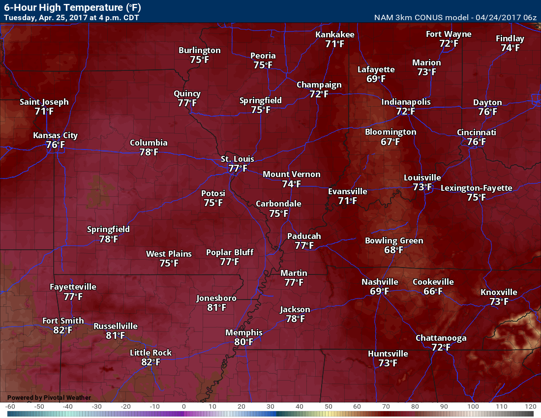
Tuesday should be a splendid day! Spring temperatures. Warmer. Nice day with plenty of sunshine. A few passing clouds. Temperatures should rise well into the 70’s by Tuesday afternoon.
Here is the 4 pm temperature map for Tuesday. Yummy temperatures! No complaints, right?
We might see an isolated thunderstorm late Tuesday night, but more likely on Wednesday and Wednesday night.
Most areas will remain dry on Tuesday night.
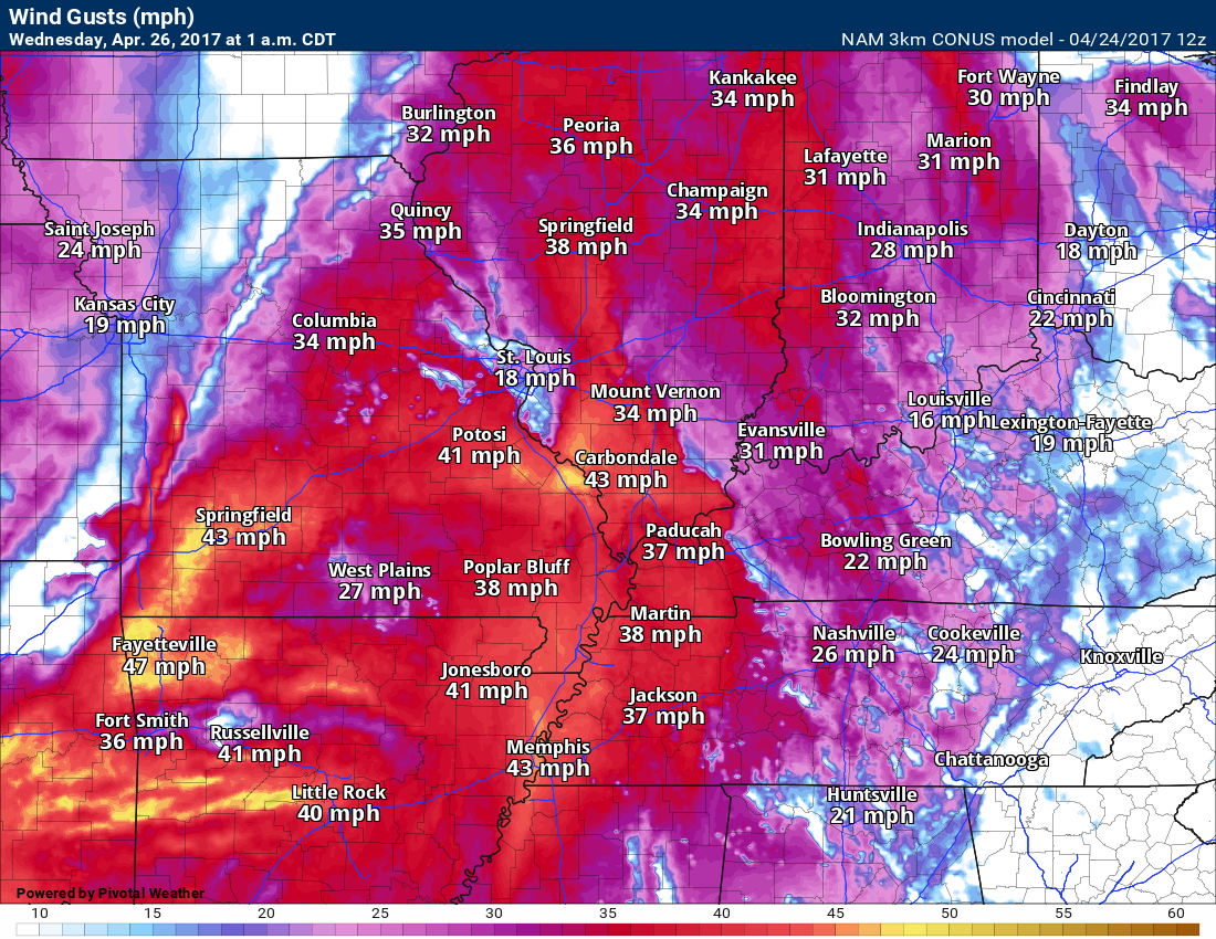
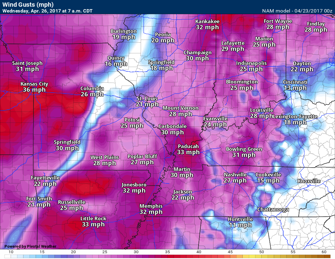
Winds will pick up on Tuesday night. Here is the wind gust forecast map for late Tuesday night. Gusts above 30 mph are a possibility.
Here is the 3K NAM guidance future-cast radar for Tuesday night.
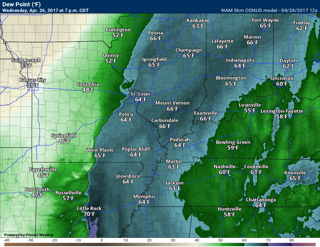
Dew points will be on the rise late Tuesday night. Look down in Arkansas. Lot of moisture streaming northward.
Future-cast radar for late Tuesday night. Just a hint of a few showers.
A storm system will take shape to our west on Wednesday. Our winds will become strong and gusty from the south. Winds on Wednesday will probably gust above 30 mph.
7 AM Wednesday wind gusts. There will be gusty winds with an incoming cold front and area of low pressure. Tighter pressure gradient.
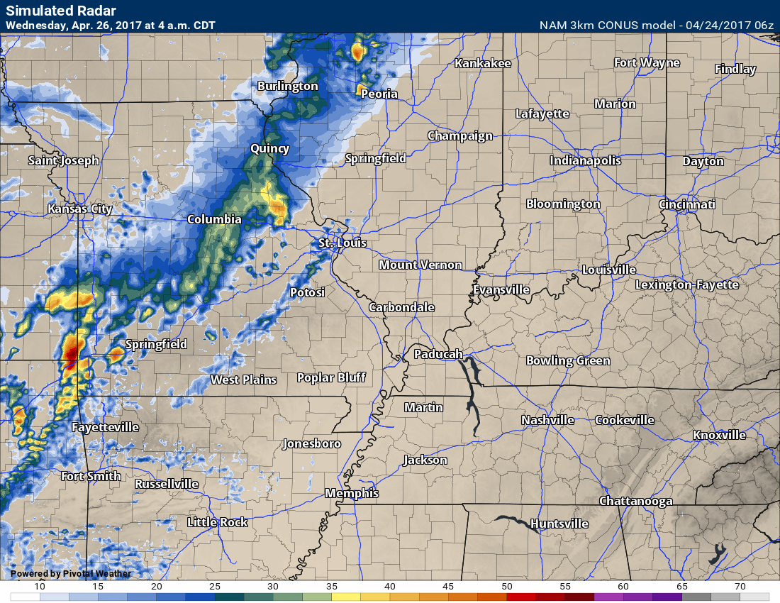
Clouds will thicken on Wednesday afternoon and night. Showers and thunderstorms will develop from west to east. There will be some CAPE (energy for storms to tap into) and the atmosphere may become unstable. I can’t rule out some strong storms on Wednesday into Wednesday night, but it is too soon to know if severe weather is a concern. As always, monitor updates.
Locally heavy rain is a concern.
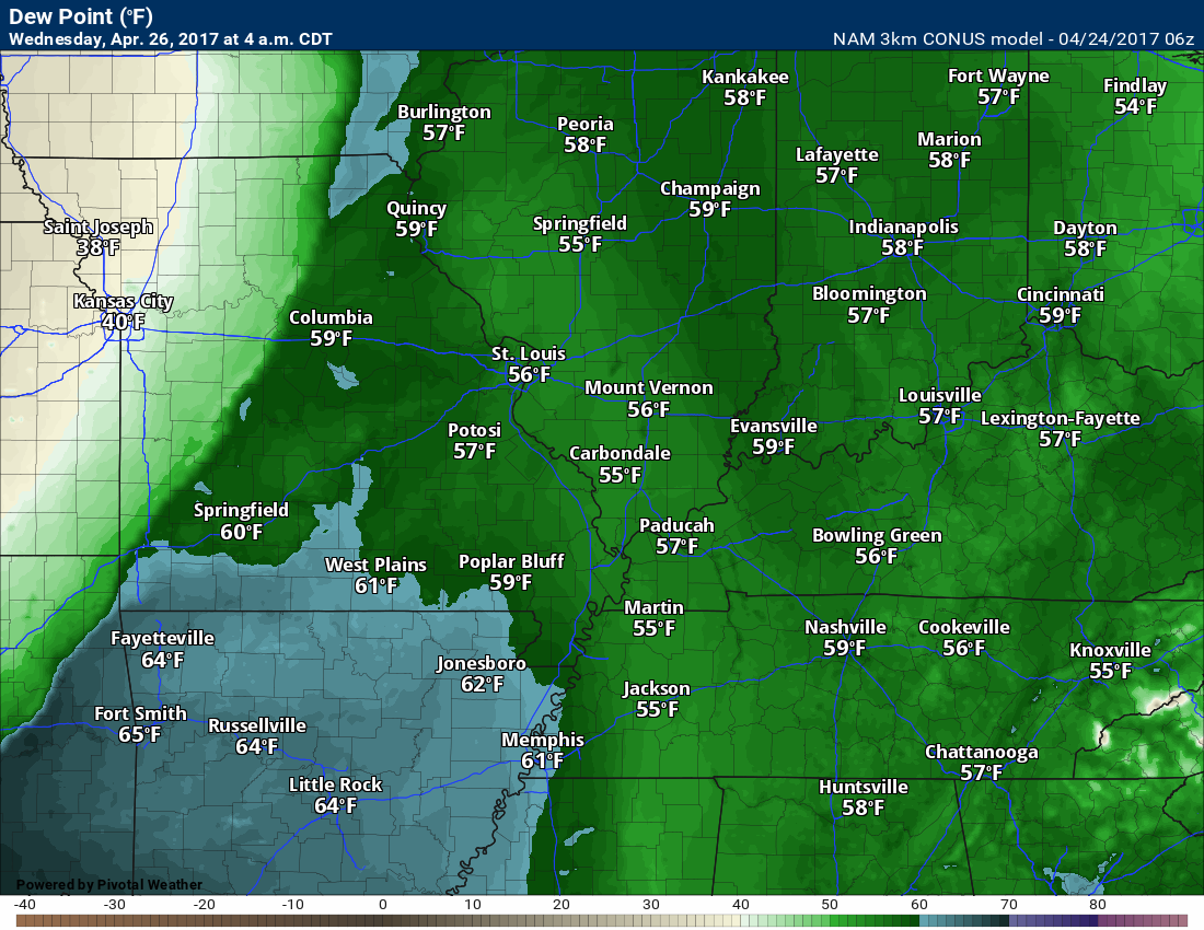
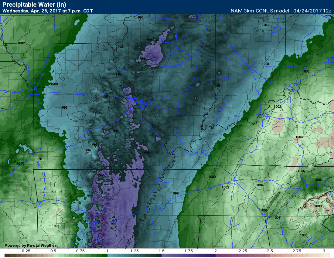
Both dew points and PWAT values will be high. Dew point is a measure of moisture in the lower atmosphere. PWAT values are a measure of moisture in the entire atmosphere. The higher both numbers the greater the risk for heavy rain.
7 PM Dew point map for Wednesday. Lot of moisture. Dew points well into the 60’s.
PWAT values for 7 PM on Wednesday
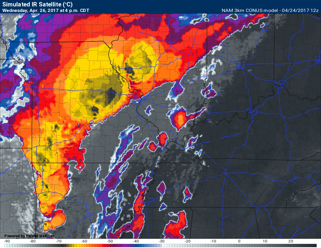
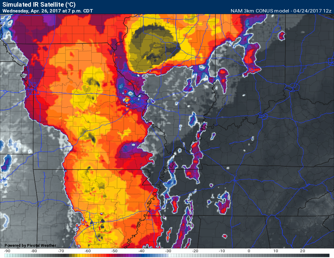
Future-cast satellite view for Wednesday at 4 and 7 pm. Look at those tall thunderstorm tops on the satellite. Severe storms across portions of Missouri and Illinois. These storms will push eastward overnight. They will likely lose some intensity. Monitor updates.
The colors represent temperatures. The colder the temperature the higher the cloud tops. Thunderstorms can reach up to 50,000′ or higher into the atmosphere. Those dark colors within the yellow are very high cloud tops. Severe thunderstorms.
and 7 pm
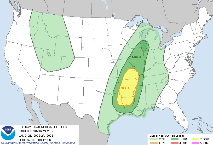
The highest risk for severe weather on Wednesday night will be over southeast Missouri. The Storm Prediction Center has already outlined this area for possible severe weather. The yellow is a slight risk. Dark green is a marginal risk. Light green represents thunderstorms, but below severe levels.
The yellow is the greatest risk zone. That is a level two risk (two out of five). The risk zones may be shifted around a bit between now and Wednesday.
Let’s keep an eye on Wednesday night. Perhaps some severe weather for southeast Missouri. Small risk elsewhere.
Showers and thunderstorms should move east of the region by Thursday morning. That will leave us with partly to mostly sunny sky conditions on Thursday. It will be a little cooler and less humid. Expect highs mostly in the 70’s.
A warm front will push through the region on Friday. A few scattered showers and thunderstorms may develop along and north of the warm front as it moves northward.
Perhaps a better chance for showers and thunderstorms on Friday night.
We will be in the warm sector of the system on Saturday into Sunday. There will be at least a chance for showers and thunderstorms on Saturday into Sunday. Some question about coverage and intensity. This part of the forecast may need some fine tuning.
A cold front will pass through the region on Sunday night. Widespread showers and thunderstorms are anticipated. Some of the rain could be heavy. Strong storms are again possible, as well. Monitor updates.
It will be a warm weekend with high temperatures well into the 70’s on both Saturday and Sunday afternoon.
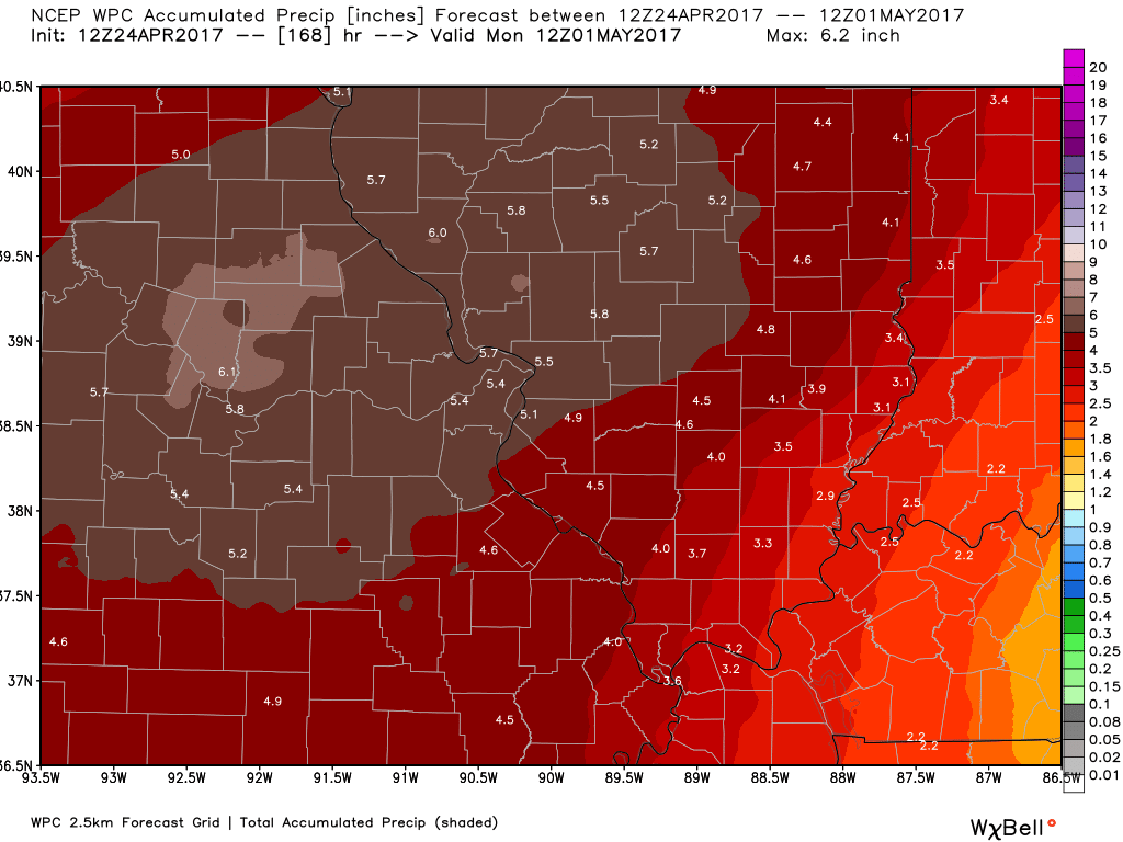
Rainfall totals between now and next Monday morning could top two inches in some locations. Some of the guidance indicates MUCH higher totals. We will need to monitor the flood potential.
Here is the latest NOAA rainfall forecast for the next seven days.
Click images to enlarge
MO IL view
KY TN view
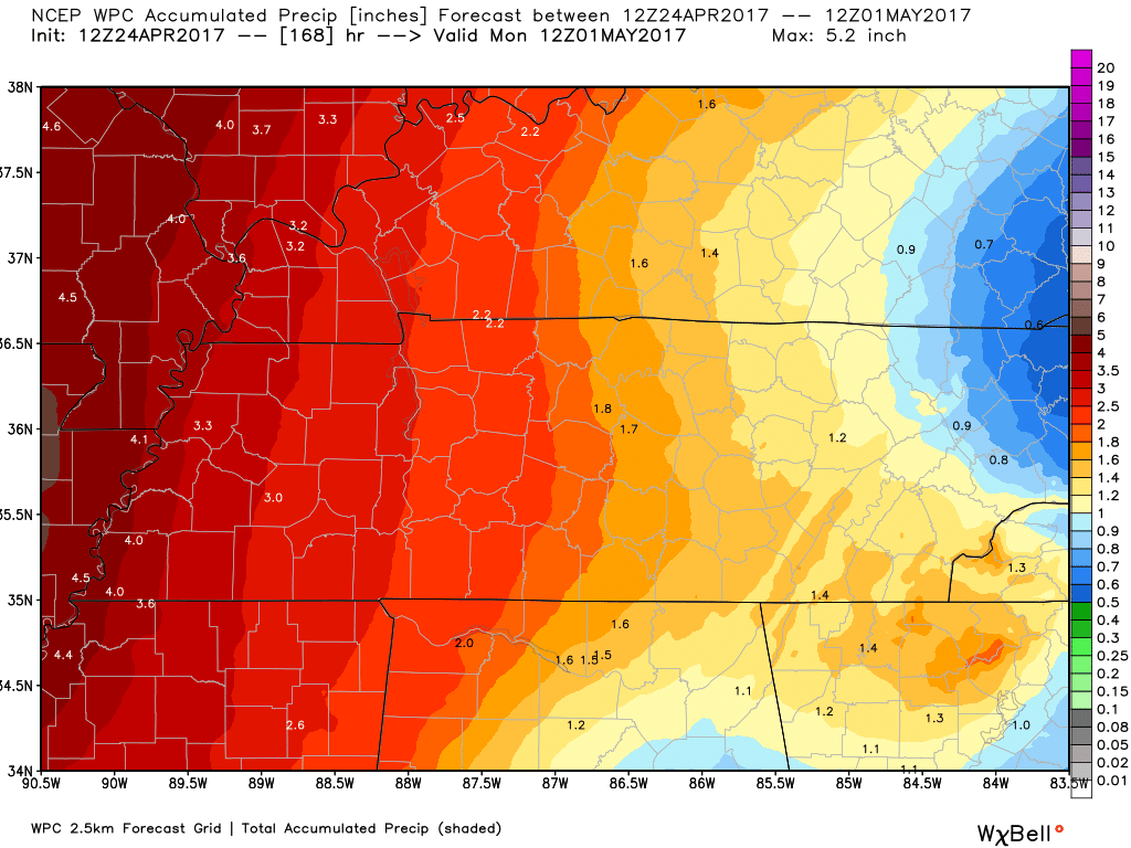
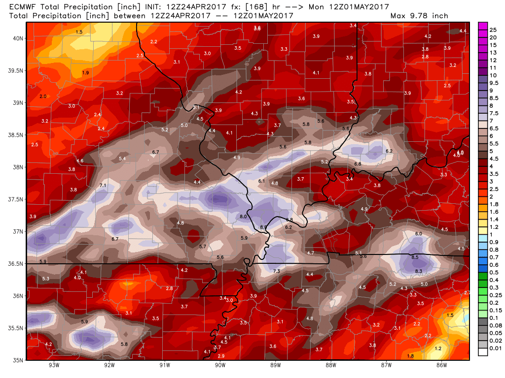
EC guidance shows very heavy rain over the coming seven days. GFS has even higher totals. This needs to be monitored.

We have regional radars and local city radars – if a radar does not update then try another one. Occasional browsers need their cache cleared. You may also try restarting your browser. That usually fixes the problem. Occasionally we do have a radar go down. That is why I have duplicates. Thus, if one fails then try another one.
During the winter you can track snow and ice by clicking the winterize button on the local city view interactive radars.
If you have any problems then please send me an email beaudodson@usawx.com
Interactive Weather Radar Page. Choose the city nearest your location: Click this link—
National interactive radar: Click this link.
Local interactive city radars include St Louis, Mt Vernon, Evansville, Poplar Bluff, Cape Girardeau, Marion, Paducah, Hopkinsville, Memphis, Nashville, Dyersburg, and all of eastern Kentucky. These are interactive radars. Local city radars – click here
Regional Radar

The official 6-10 day and 8-14 day temperature and precipitation outlook. Check the date stamp at the top of each image (so you understand the time frame).
The forecast maps below are issued by the Weather Prediction Center (NOAA)


The latest 8-14 day temperature and precipitation outlook. Note the dates are at the top of the image. These maps DO NOT tell you how high or low temperatures or precipitation will be. They simply give you the probability as to whether temperatures or precipitation will be above or below normal.


The Beau Dodson Weather APP is ready for Apple and Android users. The purpose of this app is for me to deliver your text messages instantly. ATT and Verizon have not always been reliable when it comes to speed. The app allows instant delivery.
Some of you have asked if you can keep receiving the texts on your phone and the app. The answer to that is, yes. The Android app will automatically allow that to happen. On the Apple app, however, you will need to go into your app and click settings. Make sure the green tab is OFF. Off means you will still receive the texts to your phone and the app. If you have any questions, then email me at beaudodson@usawx.com
The app is for text subscribers.
The direct download, for the Apple app, can be viewed here
https://itunes.apple.com/us/app/id1190136514
If you have not signed up for the texting service then you may do so at www.beaudodsonweather.com

The Android app is also ready.
Remember, the app’s are for www.weathertalk.com subscribers. The app allows your to receive the text messages faster than ATT and Verizon.
Here is the download link for the Android version Click Here

——————————————————–
If you have not signed up for the texts messages, then please do. Link www.beaudodsonweather.com
Your support helps with the following:

and


Who do you trust for your weather information and who holds them accountable?
I have studied weather in our region since the late 1970’s. I have 39 years of experience in observing our regions weather patterns. My degree is in Broadcast Meteorology and a Bachelor’s of Science.
My resume includes:
Member of the American Meteorological Society.
NOAA Weather-Ready Nation Ambassador.
Meteorologist for McCracken County Emergency Management. I served from 2005 through 2015.
Meteorologist for McCracken County Rescue. 2015 through current
I own and operate the Southern Illinois Weather Observatory.
I am the chief meteorologist for Weather Talk LLC. I am the owner of Weather Talk LLC.
I am also a business owner in western Kentucky.
Recipient of the Mark Trail Award, WPSD Six Who Make A Difference Award, Kentucky Colonel, and the Caesar J. Fiamma” Award from the American Red Cross.
In 2005 I helped open the largest American Cross shelter in U.S. history in Houston, Texas. I was deployed to help after Hurricane Katrina and Hurricane Rita. I was a shelter manager of one of the Houston, Texas shelter divisions.
In 2009 I was presented with the Kentucky Office of Highway Safety Award.
Recognized by the Kentucky House of Representatives for my service to the State of Kentucky leading up to several winter storms and severe weather outbreaks.
If you click on the image below you can read the Kentucky House of Representatives Resolution.

I am also President of the Shadow Angel Foundation which serves portions of western Kentucky and southern Illinois.
There is a lot of noise on the internet. A lot of weather maps are posted without explanation. Over time you should learn who to trust for your weather information.
My forecast philosophy is simple and straight forward.
- Communicate in simple terms
- To be as accurate as possible within a reasonable time frame before an event
- Interact with you on Twitter, Facebook, email, texts, and this blog
- Minimize the “hype” that you might see on some television stations or through other weather sources
- Push you towards utilizing wall-to-wall LOCAL TV coverage during severe weather events
Many of the graphics on this page are from www.weatherbell.com
WeatherBell is a great resource for weather model guidance.


You can sign up for my AWARE email by clicking here I typically send out AWARE emails before severe weather, winter storms, or other active weather situations. I do not email watches or warnings. The emails are a basic “heads up” concerning incoming weather conditions