Monday morning update


This forecast update covers far southern Illinois, far southeast Missouri, and far western Kentucky. See the coverage map on the right side of the blog
April 23, 2017
Sunday Night Forecast Details:
Forecast: Clouds and showers over our eastern counties will exit through the evening hours. Becoming clear to partly cloudy overnight. Chilly.
Temperatures: MO ~ 42 to 46 IL ~ 42 to 46 KY ~ 44 to 48 TN ~ 44 to 48
Winds: North and northeast winds at 10 to 20 mph and gusty before 10 pm. Winds becoming north and northeast at 5 to 10 mph late.
My confidence in the forecast verifying: High. This forecast should verify..
What impacts are anticipated from the weather? Perhaps some wet roadways early.
Is severe weather expected? No
The NWS defines severe weather as 58 mph winds or great, 1″ hail or larger, and/or tornadoes
What is the chance of precipitation? MO ~ 20% IL ~ 20% KY ~ 50% TN ~ 40%
Coverage of precipitation: Scattered over our eastern counties before 10 pm.
Should I cancel my outdoor plans? No, but check radars.
.
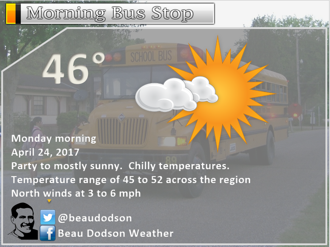
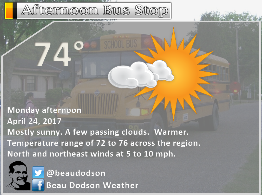
April 24, 2017
Monday Forecast Details
Forecast: Mostly sunny. Mild. Nice day anticipated. Warmer.
Temperatures: MO ~ 68 to 74 IL ~ 68 to 74 KY ~ 70 to 75 TN ~ 70 to 75
Winds: North and northeast winds at 5 to 10 mph with gusts to 15 mph
What impacts are anticipated from the weather? None
My confidence in the forecast verifying: High. This forecast should verify.
Is severe weather expected? No
The NWS defines severe weather as 58 mph winds or great, 1″ hail or larger, and/or tornadoes
What is the chance of precipitation? MO ~ 0% IL ~ 0% KY ~ 0% TN ~ 0%
Coverage of precipitation: None
Should I cancel my outdoor plans? No
Sunrise will be at 6:06 a.m. and sunset will be at 7:38 p.m.
.
Monday Night Forecast Details:
Forecast: Clear and cool. Perhaps late night patchy fog.
Temperatures: MO ~ 48 to 54 IL ~ 48 to 54 KY ~ 50 to 54 TN ~ 50 to 55
Winds: Winds becoming east and southeast at 0 to 5 mph.
My confidence in the forecast verifying: High. This forecast should verify..
What impacts are anticipated from the weather? Perhaps some late night fog. Otherwise, no impacts.
Is severe weather expected? No
The NWS defines severe weather as 58 mph winds or great, 1″ hail or larger, and/or tornadoes
What is the chance of precipitation? MO ~ 0% IL ~ 0% KY ~ 0% TN ~ 0%
Coverage of precipitation: None.
Should I cancel my outdoor plans? No
.
April 25, 2017
Tuesday Forecast Details
Forecast: Mostly sunny. Mild. Another nice day anticipated. Warmer.
Temperatures: MO ~ 75 to 80 IL ~ 75 to 80 KY ~ 75 to 80 TN ~ 75 to 80
Winds: South and southeast at 6 to 12 mph with gusts to 18 mph.
What impacts are anticipated from the weather? None
My confidence in the forecast verifying: High. This forecast should verify.
Is severe weather expected? No
The NWS defines severe weather as 58 mph winds or great, 1″ hail or larger, and/or tornadoes
What is the chance of precipitation? MO ~ 0% IL ~ 0% KY ~ 0% TN ~ 0%
Coverage of precipitation: None
Should I cancel my outdoor plans? No
Sunrise will be at 6:07 a.m. and sunset will be at 7:37 p.m.
Tuesday Night Forecast Details:
Forecast: Breezy. Partly cloudy. A 20% for a late night thunderstorm over southeast Missouri and southwest Illinois. Most areas will remain dry.
Temperatures: MO ~ 58 to 64 IL ~ 58 to 64 KY ~ 58 to 64 TN ~ 60 to 65
Winds: South at 7 to 14 mph with gusts over 25 mph
My confidence in the forecast verifying: Medium. Some adjustments are possible.
What impacts are anticipated from the weather? A few late night storms could produce lightning. Wet roadways.
Is severe weather expected? No
The NWS defines severe weather as 58 mph winds or great, 1″ hail or larger, and/or tornadoes
What is the chance of precipitation? MO ~ 20% IL ~ 20% KY ~ 10% TN ~ 10%
Coverage of precipitation: Perhaps isolated late at night over our western counties (SE MO/SW IL)
Should I cancel my outdoor plans? No
.
April 26, 2017
Wednesday Forecast: Partly to mostly cloudy. Scattered storms possible, mainly during the afternoon hours. Some storms could be strong late in the day. Breezy. Temperatures will be several degrees warmer if we have some sunshine.
Temperatures: MO ~ 74 to 78 IL ~ 74 to 78 KY ~ 74 to 78 TN ~ 74 to 78
Winds: South at 8 to 16 mph with gusts to 25 mph
What impacts are anticipated from the weather? Lightning. Downpours. Monitor severe weather risk late in the day.
My confidence in the forecast verifying: Medium. Some adjustments are possible.
Is severe weather expected? Some intense storms possible late in the afternoon.
The NWS defines severe weather as 58 mph winds or great, 1″ hail or larger, and/or tornadoes
What is the chance of precipitation? MO ~ 50% IL ~ 40% KY ~ 30% TN ~ 30%
Coverage of precipitation: Scattered (mainly during the afternoon hours)
Should I cancel my outdoor plans? Monitor radars
Sunrise will be at 6:04 a.m. and sunset will be at 7:39 p.m.
Wednesday Night Forecast Details:
Forecast: Cloudy. Showers and thunderstorms likely. Some storms could be strong with high winds and hail. Heavy downpours possible. Gusty winds.
Temperatures: MO ~ 48 to 54 IL ~ 48 to 54 KY ~ 50 to 55 TN ~ 50 to 55
Winds: South and southwest becoming west and northwest at 10 to 20 mph.
My confidence in the forecast verifying: Medium. Some adjustments are possible.
What impacts are anticipated from the weather? Wet roadways. Lightning. Heavy downpours. A few storms could be intense.
Is severe weather expected? Perhaps
The NWS defines severe weather as 58 mph winds or great, 1″ hail or larger, and/or tornadoes
What is the chance of precipitation? MO ~ 90% IL ~ 90% KY ~ 90% TN ~ 90%
Coverage of precipitation: Widespread as the night wears on.
Should I cancel my outdoor plans? Have a plan B.
.
April 27, 2017
Thursday Forecast Details
Forecast: Partly cloudy. Cooler. Less humid.
Temperatures: MO ~ 60 to 65 IL ~ 60 to 65 KY ~ 60 to 65 TN ~ 60 to 65
Winds: West and northwest winds at 5 to 10 mph with gusts to 14 mph
What impacts are anticipated from the weather? None
My confidence in the forecast verifying: Medium. Some adjustments are possible.
Is severe weather expected? No
The NWS defines severe weather as 58 mph winds or great, 1″ hail or larger, and/or tornadoes
What is the chance of precipitation? MO ~ 0% IL ~ 0% KY ~ 0% TN ~ 0%
Coverage of precipitation: None
Should I cancel my outdoor plans? No
Sunrise will be at 6:02 a.m. and sunset will be at 7:40 p.m.
Thursday Night Forecast Details:
Forecast: Partly cloudy. A slight chance for thunderstorms after 1 am.
Temperatures: MO ~ 54 to 58 IL ~ 54 to 58 KY ~ 54 to 58 TN ~ 54 to 58
Winds: South and southeast at 5 to 10 mph with gusts to 15 mph
My confidence in the forecast verifying: Low. Significant adjustments are possible.
What impacts are anticipated from the weather? Scattered late night storms possible. Best chance would be southeast Missouri.
Is severe weather expected? No
The NWS defines severe weather as 58 mph winds or great, 1″ hail or larger, and/or tornadoes
What is the chance of precipitation? MO ~ 30% IL ~ 20% KY ~ 20% TN ~ 20%
Coverage of precipitation: Isolated to scattered late at night.
Should I cancel my outdoor plans? No
.
April 28, 2017
Friday Forecast Details
Forecast: Partly cloudy. Isolated thunderstorms possible. Warm.
Temperatures: MO ~ 75 to 80 IL ~ 74 to 78 KY ~ 75 to 80 TN ~ 75 to 80
Winds: South and southeast winds at 6 to 12 mph with gusts to 20 mph
What impacts are anticipated from the weather? Lightning. Wet roadways.
My confidence in the forecast verifying: Medium. Some adjustments are possible.
Is severe weather expected? No
The NWS defines severe weather as 58 mph winds or great, 1″ hail or larger, and/or tornadoes
What is the chance of precipitation? MO ~ 20% IL ~ 20% KY ~ 20% TN ~ 20%
Coverage of precipitation: Isolated
Should I cancel my outdoor plans? No, but monitor radars.
Sunrise will be at 6:02 a.m. and sunset will be at 7:41 p.m.
Friday Night Forecast Details:
Forecast: Becoming cloudy. Showers and thunderstorms possible. Locally heavy downpours possible.
Temperatures: MO ~ 62 to 66 IL ~ 62 to 66 KY ~ 62 to 66 TN ~ 62 to 66
Winds: South winds at 6 to 12 mph
My confidence in the forecast verifying: Low. Significant adjustments are possible.
What impacts are anticipated from the weather? Lightning. Gusty winds. Wet roadways.
Is severe weather expected? Not at this time, but monitor updates.
The NWS defines severe weather as 58 mph winds or great, 1″ hail or larger, and/or tornadoes
What is the chance of precipitation? MO ~ 50% IL ~ 50% KY ~ 50% TN ~ 50%
Coverage of precipitation: Scattered.
Should I cancel my outdoor plans? Monitor updated forecasts. Some storms are possible Friday night.
.
April 29, 2017
Saturday Forecast Details
Forecast: Partly sunny. A 40% for morning showers and thunderstorms. A 20% for afternoon showers and thunderstorms. Mild. Breezy, at times.
Temperatures: MO ~ 75 to 80 IL ~ 74 to 78 KY ~ 75 to 80 TN ~ 75 to 80
Winds: South winds at 6 to 12 mph with gusts to 20 mph
What impacts are anticipated from the weather? Lightning. Wet roadways.
My confidence in the forecast verifying: Medium. Some adjustments are possible.
Is severe weather expected? No
The NWS defines severe weather as 58 mph winds or great, 1″ hail or larger, and/or tornadoes
What is the chance of precipitation? MO ~ 40% IL ~ 40% KY ~ 30% TN ~ 30%
Coverage of precipitation: Scattered in the morning. Isolated in the afternoon.
Should I cancel my outdoor plans? No, but monitor radars.
Sunrise will be at 6:00 a.m. and sunset will be at 7:42 p.m.
Saturday Night Forecast Details:
Forecast: Partly cloudy. Warm. A slight chance for a thunderstorm.
Temperatures: MO ~ 65 to 70 IL ~ 65 to 70 KY ~ 65 to 70 TN ~ 65 to 70
Winds: South winds at 6 to 12 mph with gusts to 18 mph
My confidence in the forecast verifying: Low. Significant adjustments are possible.
What impacts are anticipated from the weather? Lightning. Gusty winds. Wet roadways.
Is severe weather expected? Not at this time, but monitor updates.
The NWS defines severe weather as 58 mph winds or great, 1″ hail or larger, and/or tornadoes
What is the chance of precipitation? MO ~ 20% IL ~ 20% KY ~ 20% TN ~ 20%
Coverage of precipitation: Isolated.
Should I cancel my outdoor plans? No, but monitor updated forecasts.
.
Bus stop forecast
.
.

Don’t forget to check out the Southern Illinois Weather Observatory web-site for weather maps, tower cams, scanner feeds, radars, and much more! Click here

An explanation of what is happening in the atmosphere over the coming day

Severe thunderstorm outlook.
Remember that a severe thunderstorm is defined as a thunderstorm that produces 60 mph winds or higher, quarter size hail or larger, and/or a tornado.
Sunday night: Severe weather is not anticipated. An evening thunderstorm over the Pennyrile area of western Kentucky could produce pea size hail and lightning. Small risk for cold air funnels.
Monday into Tuesday: Severe weather is not anticipated.
Tuesday night: Most likely dry. A small risk for a thunderstorm late at night over southeast Missouri and southwest Illinois. Lightning would be the primary concern.
Wednesday and Wednesday night: Thunderstorms likely. A few storms could be intense. Locally heavy rain possible. Monitor updates.
Thursday and Thursday night: Dry Thursday, but perhaps a storm after 2 am on Thursday night/Friday morning.
Friday into Saturday night: Thunderstorms likely. Some storms could be intense. Locally heavy rain possible. Monitor updates.
Sunday into Monday: Storm chances may increase late on Sunday into Monday. Locally heavy rain possible. Monitor updates.
———————————
Weather analysis for the next few days:
Portions of the region had plenty of sunshine on Sunday and others areas remain socked in with clouds and even showers.
Check out this visible satellite photo from Sunday morning
Black is clear and sunny. White represents the clouds. What a difference a few miles made today.
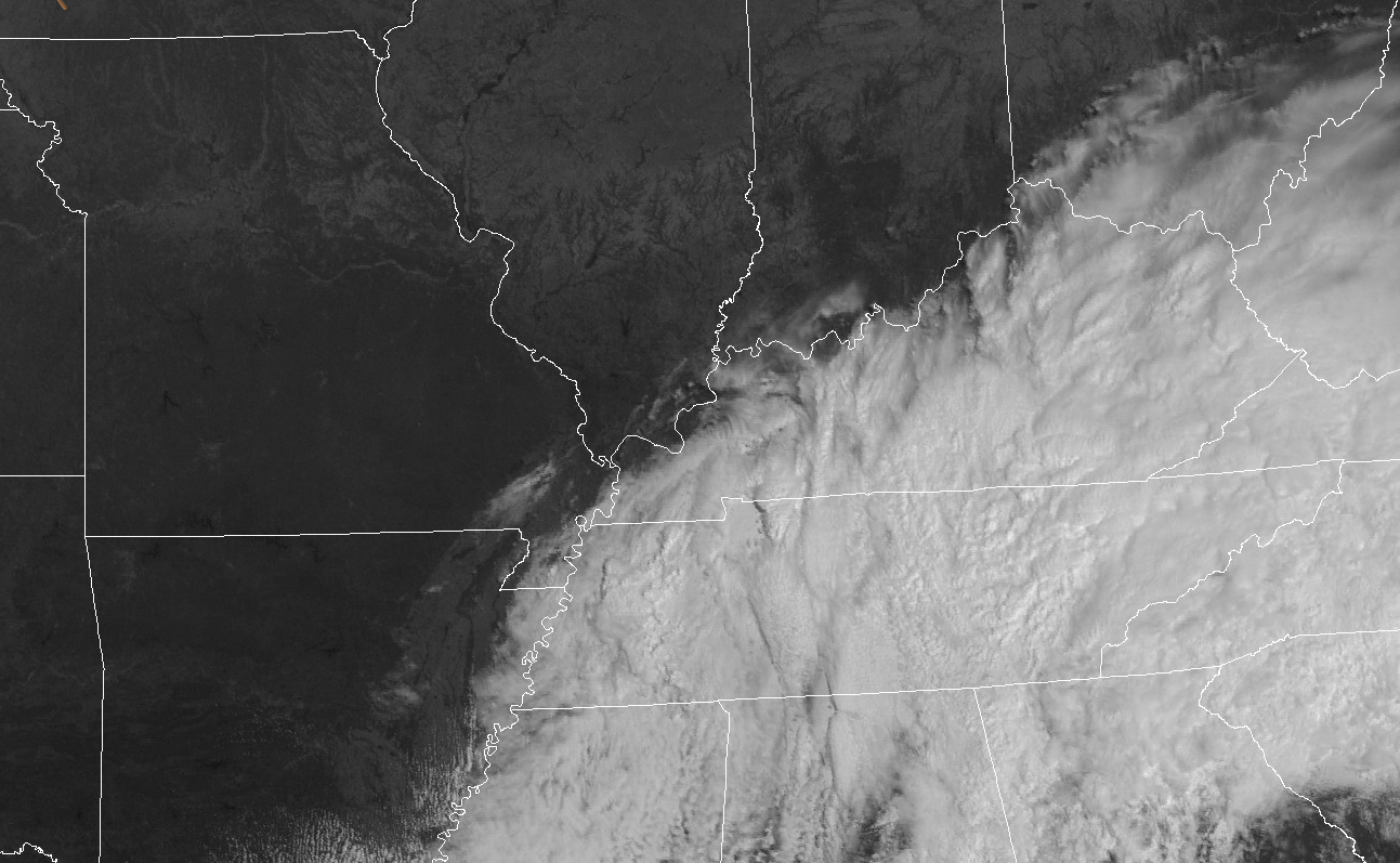
Showers and thunderstorms will come to an end on Sunday evening over western Kentucky and Tennessee.
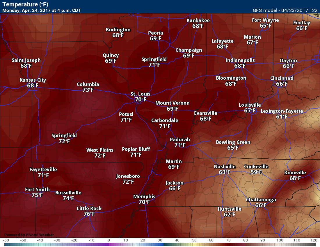
Monday and Tuesday:
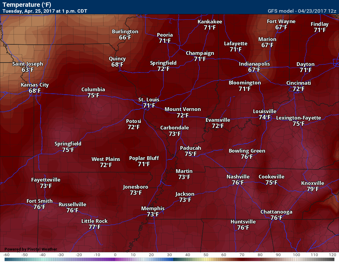
Monday and Tuesday should deliver plenty of sunshine and milder temperatures. It should feel like spring, once again. Highs on Monday will reach into the upper 60’s to middle 70’s. Highs on Tuesday should reach into the middle to upper 70’s. Nice!
Here is the 4 pm temperature map for Monday
Here is the 1 pm temperature map for Tuesday (it will be even warmer as we push through Tuesday afternoon)
We might see an isolated thunderstorm late Tuesday night, but more likely on Wednesday and Wednesday night.
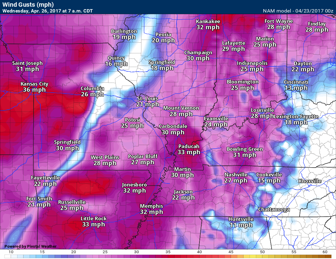
A storm system will take shape to our west on Tuesday night and Wednesday. Our winds will become strong and gusty from the south. Winds on Wednesday will probably gust above 30 mph.
7 AM Wednesday wind gusts. Winds could be even stronger during the morning and afternoon hours of Wednesday. There will be gusty winds with an incoming cold front and area of low pressure. Tighter pressure gradient.
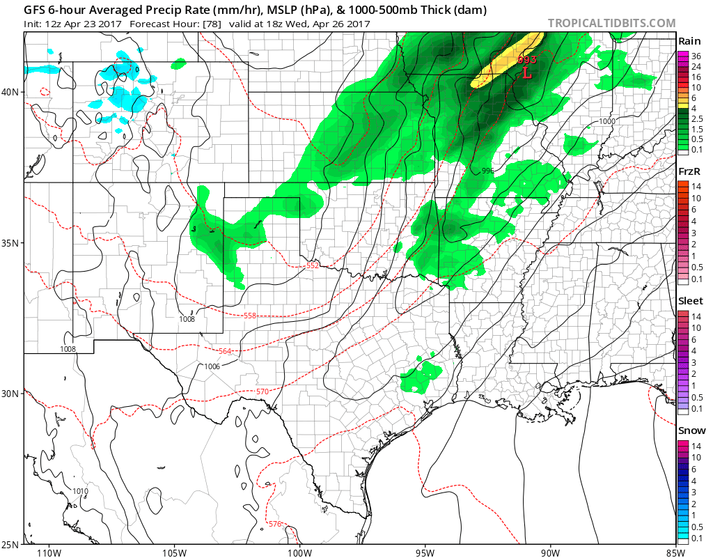
Clouds will thicken on Wednesday afternoon and night. Showers and thunderstorms will develop from west to east. There will be some CAPE (energy for storms to tap into) and the atmosphere may become unstable. I can’t rule out some strong storms on Wednesday into Wednesday night, but it is too soon to know if severe weather is a concern. As always, monitor updates.
Locally heavy rain is a concern.
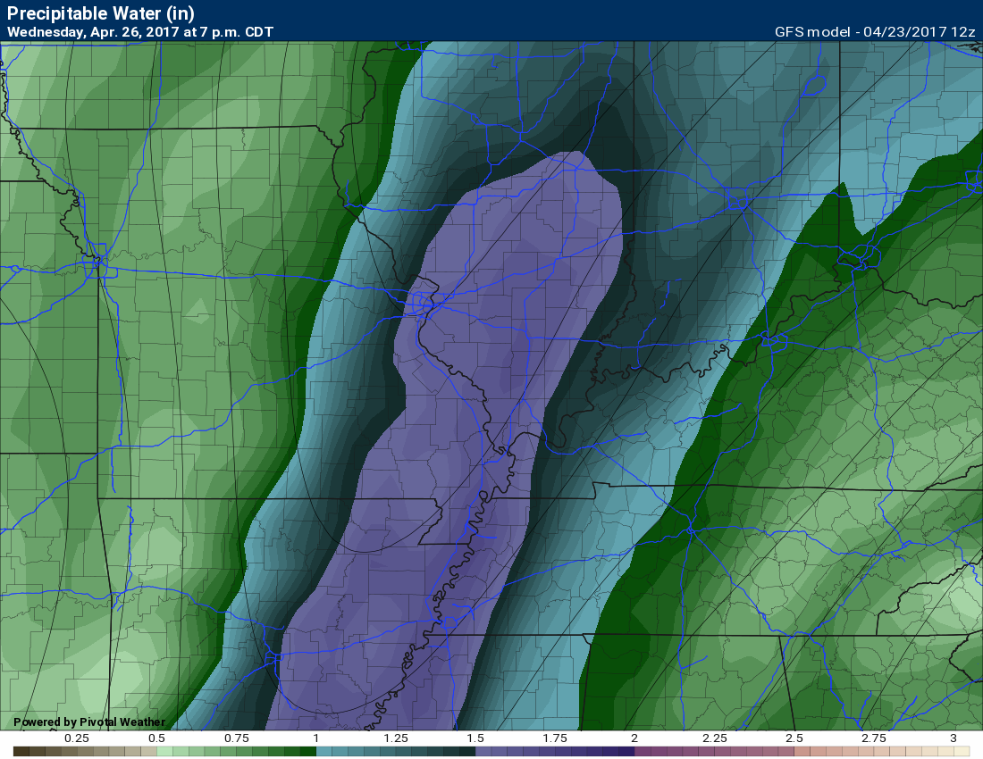
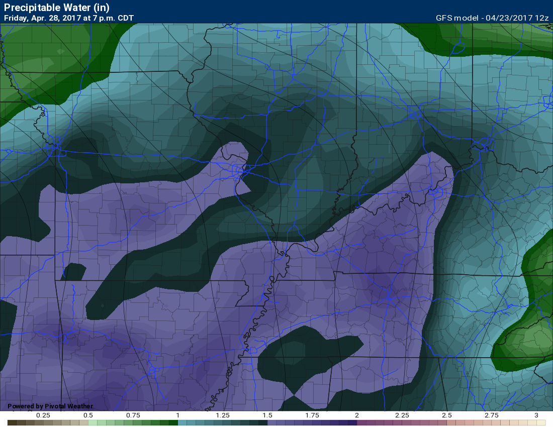
7 PM Wednesday PWAT values
PWAT values are high, as well. PWAT is a measure of moisture in the entire atmosphere. The higher the PWAT numbers the greater the risk for heavy rain.
You can see the higher PWAT numbers pooling ahead of the cold front. The purple colors are high PWAT values. Heavy rain likely along the cold front on Wednesday night.
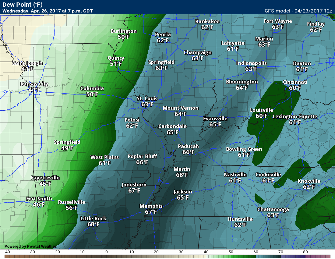
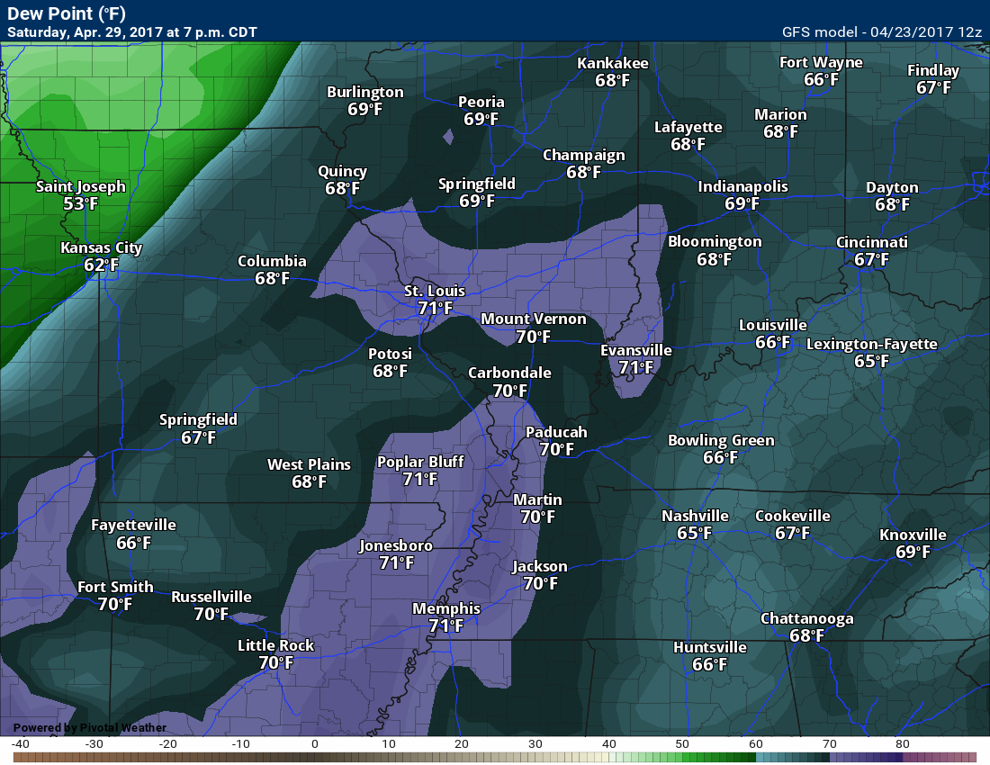
Dew points will be on the rise, as well. Dew points is a measure of moisture near the surface. Dew points in the 60’s are sufficient for heavy storms.
This is the Wednesday evening dew point map.
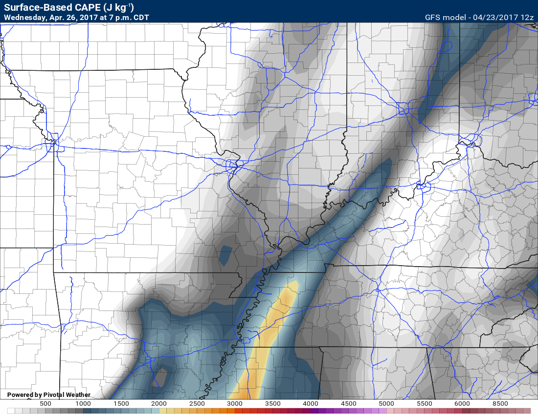
This is the CAPE forecast for 7 pm on Wednesday. Some CAPE. Not extreme, but enough for storms.
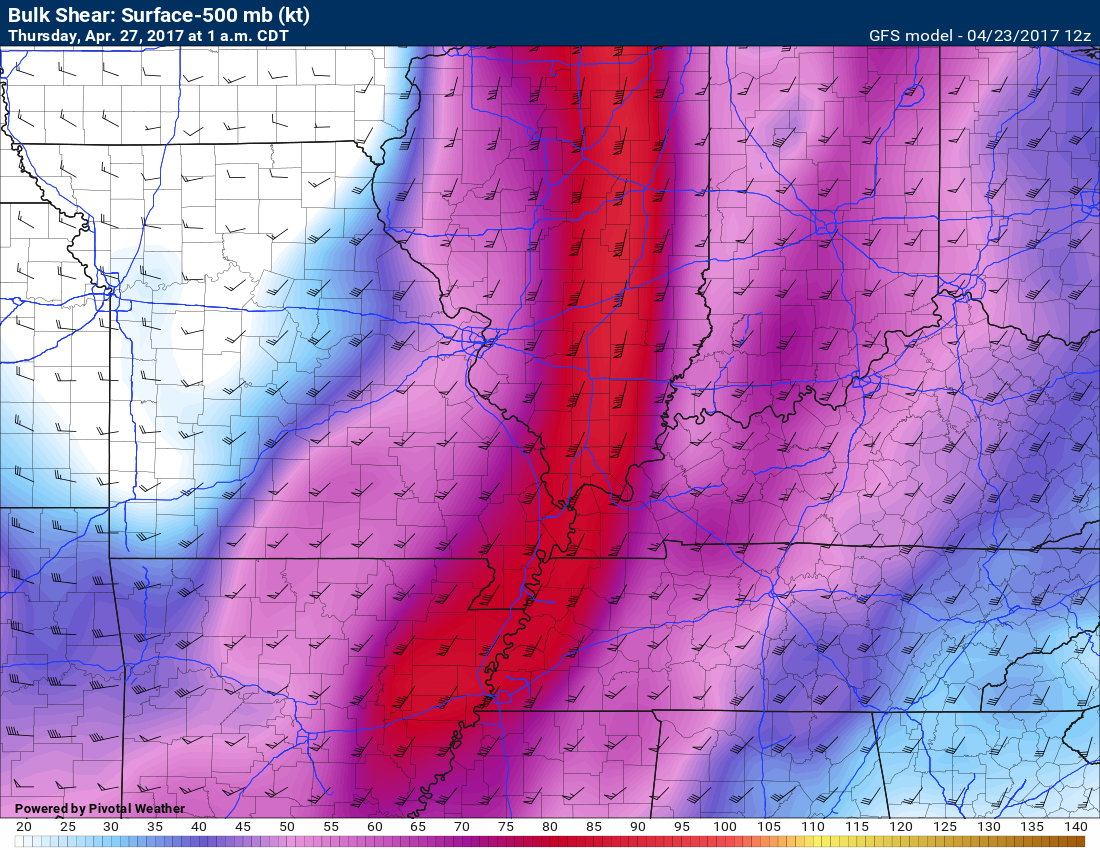
Bulk wind shear is impressive on Wednesday night. A lot of shear for storms to work with. This means strong winds aloft. That is one ingredient for strong to severe thunderstorms.
This could mean a squall line with high winds and QLCS embedded spin-ups. Too soon for confidence, but I will be monitoring it.
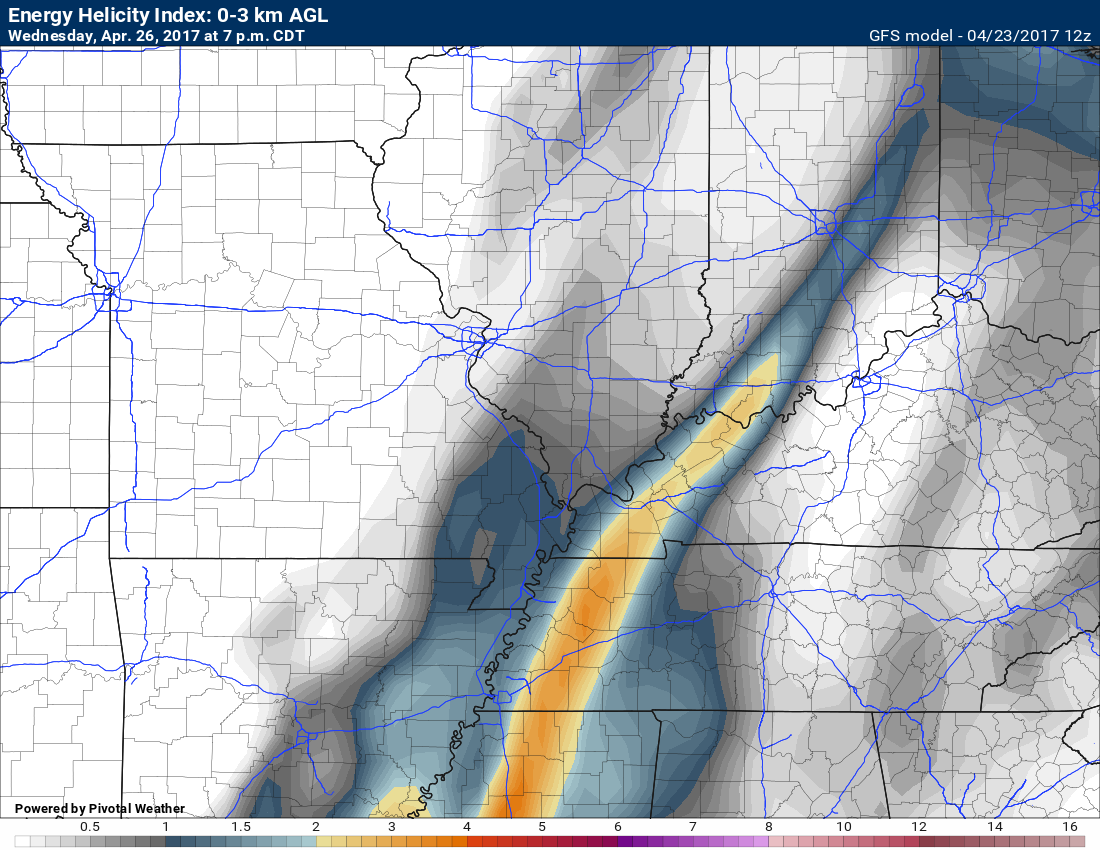
Here is the EHI numbers for Wednesday evening. I typically look at these numbers when thinking about storms have some potential to rotate.
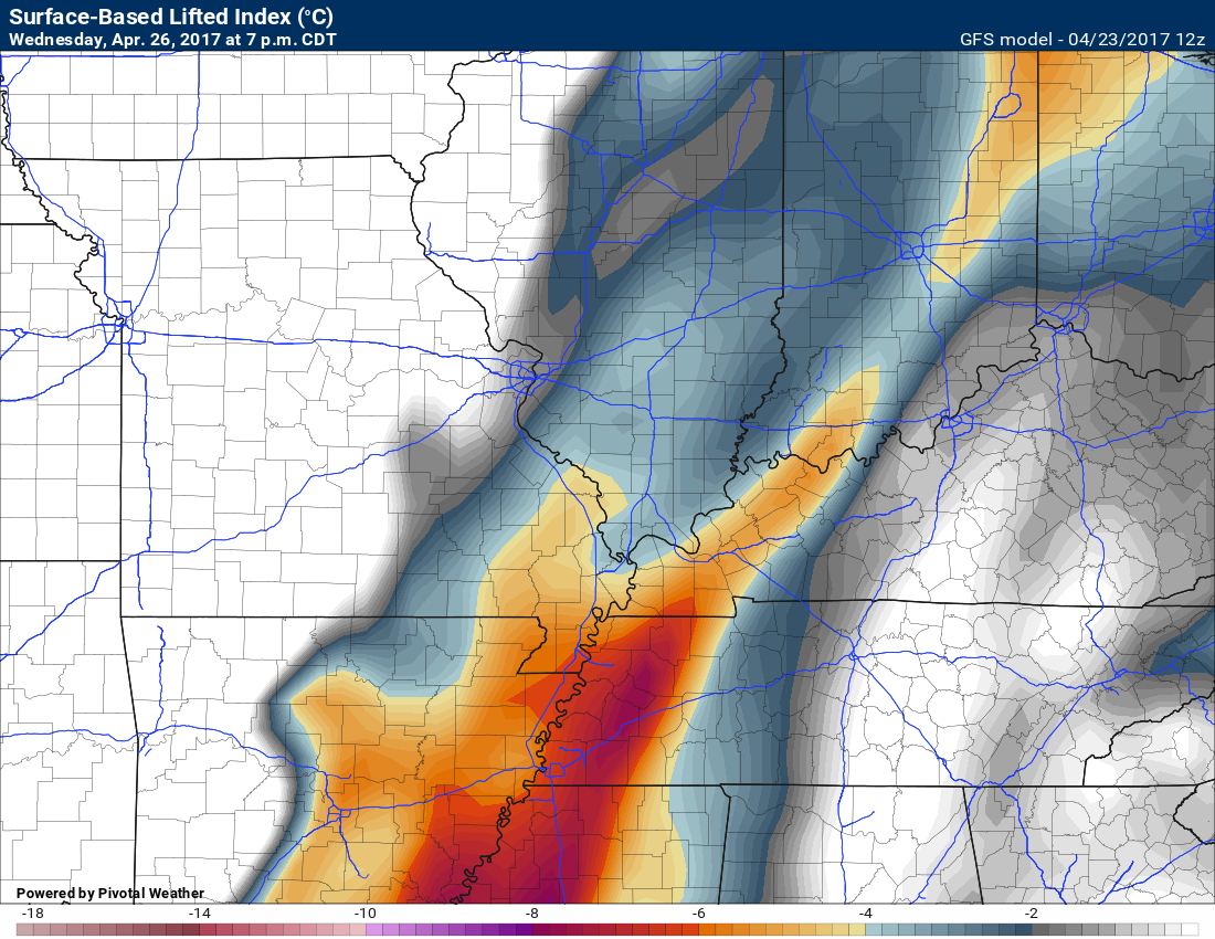
Lift index values pop on Wednesday afternoon and night, as well. Another ingredient I look at when forecasting strong storms.
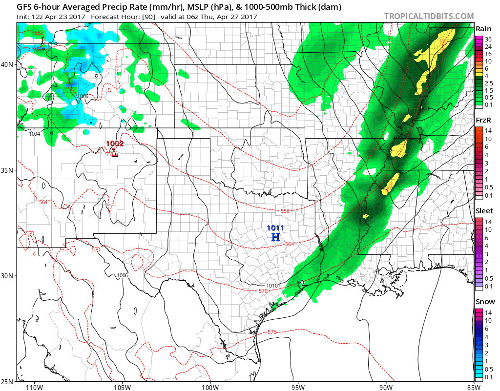
Showers and thunderstorms will continue until frontal passage on Wednesday night and Thursday morning. Most of Thursday should remain dry, but some early morning showers are possible over our eastern counties. That would include the Pennyrile area of western Kentucky. If the front advances through the area fast enough then the rain will end before sunrise.
Here is the Wednesday 1 pm weather map. Yellow is heavy rain, dark green is moderate rain, and light green would be lighter showers. You can see the area of low pressure over western Illinois. A cold front drags back towards the southwest.
Thursday 1 am weather map. Cold front moving through our region. Locally heavy rain and storms.
If this is correct then it will be a late night event for portions of our area. Let’s watch late Wednesday afternoon into Wednesday night.
Thursday and Thursday night will be cooler and less humid. This will be behind the cold front.
Our winds will once again become southerly late Thursday night and on Friday. Gusty winds possible on Friday. Yet another cold front will enter our region from the west by Friday afternoon into Saturday. Showers and locally heavy thunderstorms will once again develop along the front.
There could be some strong storms on Friday into Saturday, but it is too far out for any confidence.
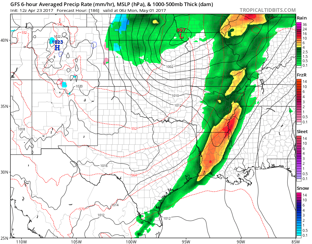
Friday evening weather map. A bit messy. Showers and thunderstorms.
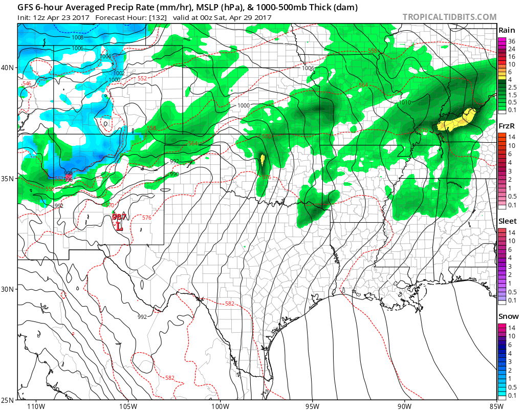
Saturday 1 pm weather map.
Showers and thunderstorms in the area.
Models are showing dew points into the upper 60’s and lower 70’s by Friday night and Saturday. If this is true then heavy rain will be possible.
PWAT are high, as well. PWAT is a measure of moisture in the entire atmosphere. The higher the PWAT numbers the greater the risk for heavy rain.
7 PM Friday PWAT values
7 PM SATURDAY PWAT values
Here is the dew point map for Saturday afternoon and evening. These are high numbers. If this verifies then it will feel soupy outside.
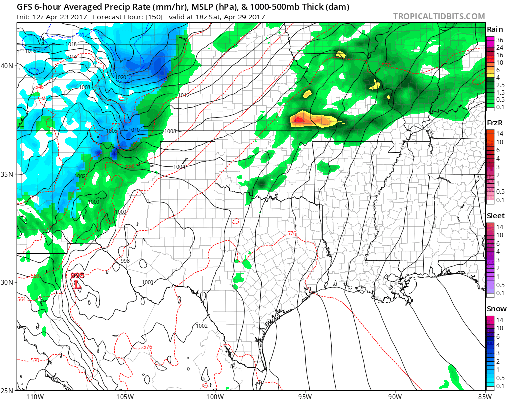
Sunday evening weather map shows yet another cold front with showers and thunderstorms.
Another round of storms is possible Sunday night and Monday.
Active!!
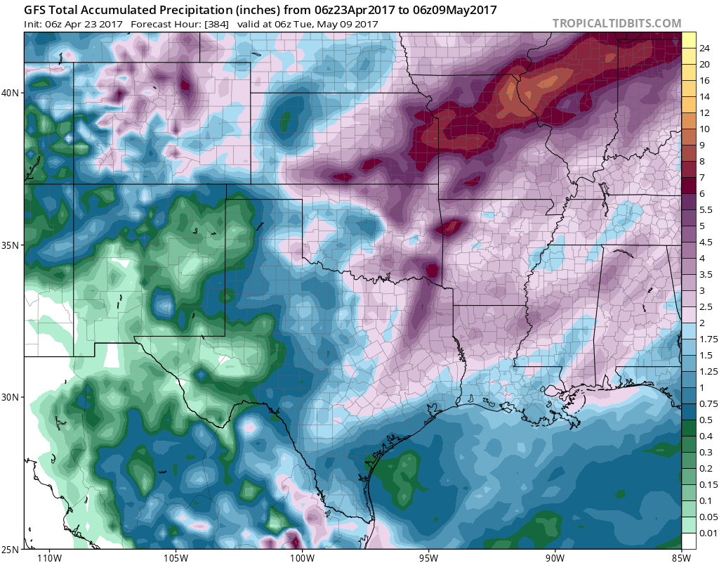
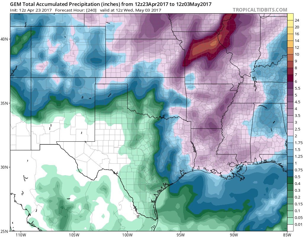
Rainfall totals could be quite heavy over the coming seven to ten days. Let’s look at some maps.
What you should NOT take from these maps are specifics.
There are many variables as to who receives what amount of rain. Thunderstorms can quickly double rain amounts. Portions of the region received more than 5 inches of rain over the past three days. Other portions of the area received less than 0.50″. Big differences from one county to the next.
What is being signaled is the potential for heavy rain over the coming seven to ten days.
Again, don’t walk away with specifics from these numbers. There will be some heavy rain over the coming days.
CLICK IMAGES TO ENLARGE
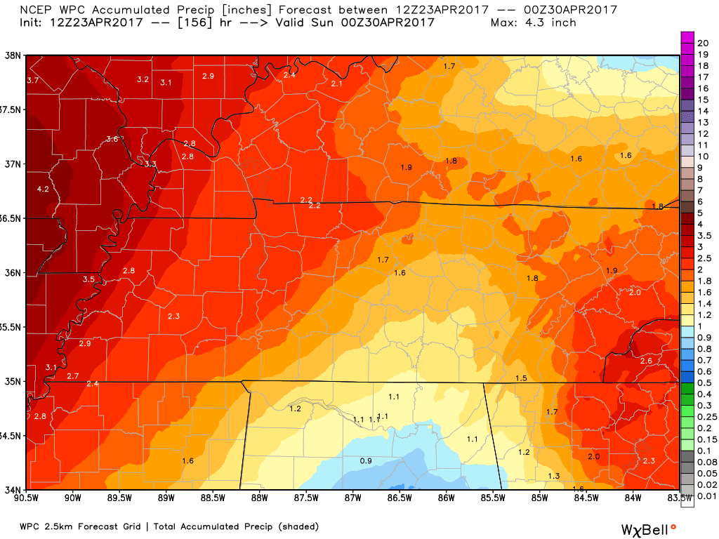
WPC/NOAA forecast for the next seven days
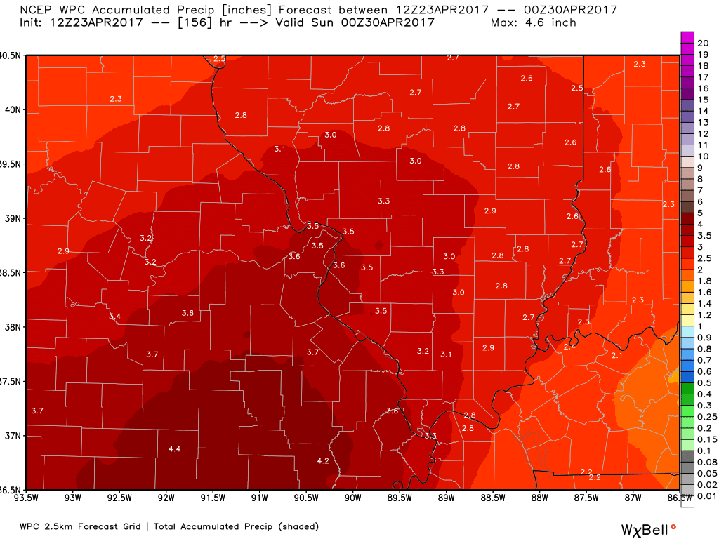
WPC NOAA forecast for the next seven days.
Click to enlarge.
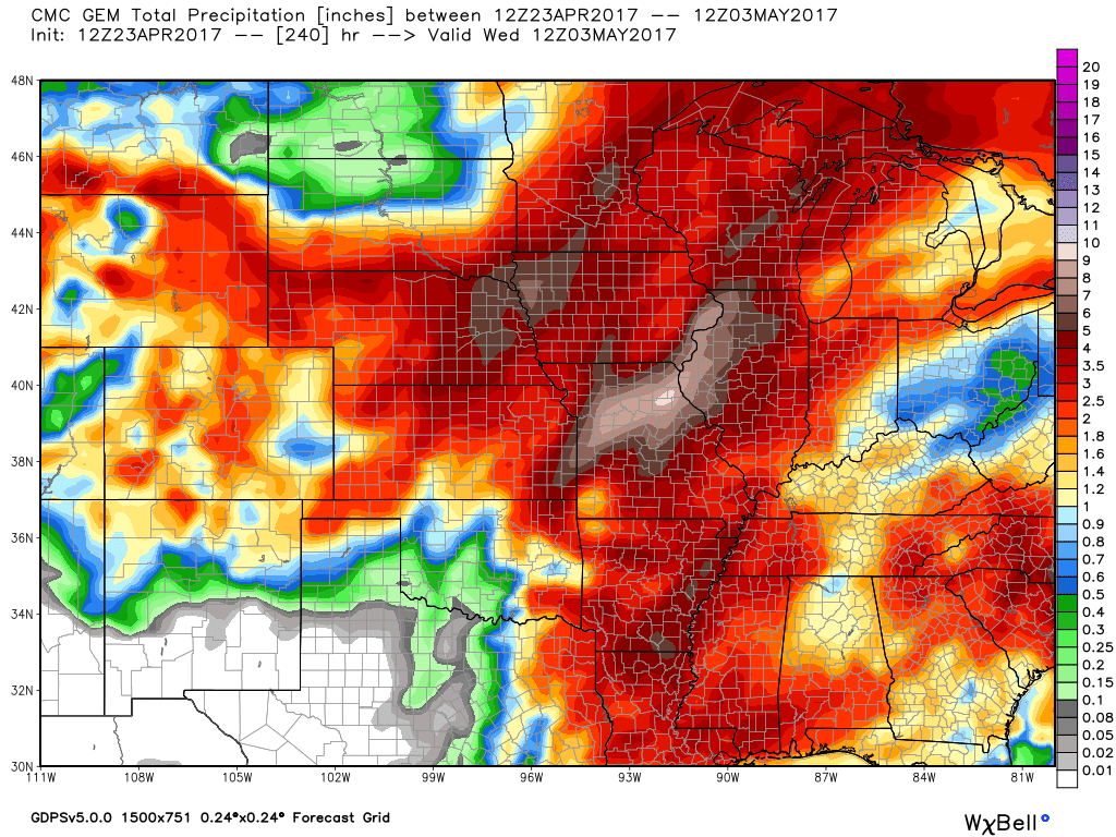
This is the GEM model guidance now through May 3rd.
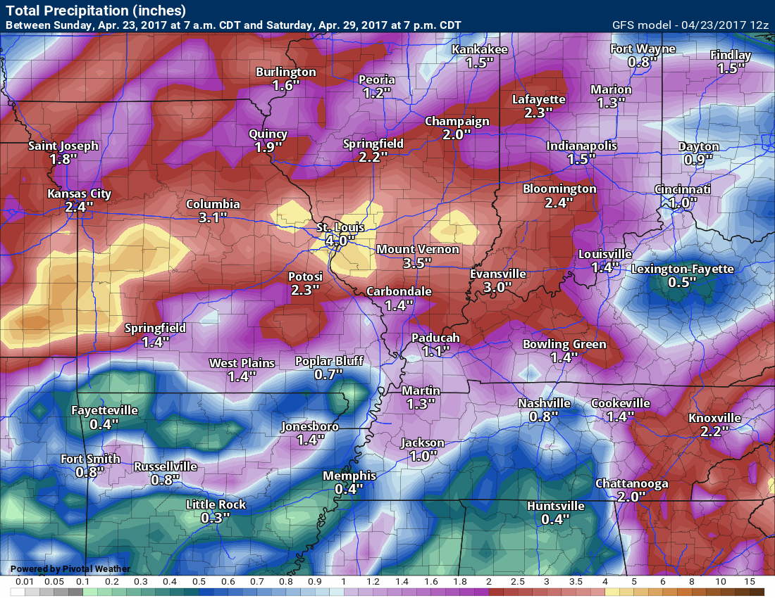
This is the GFS model forecast for rainfall from now through April 29th
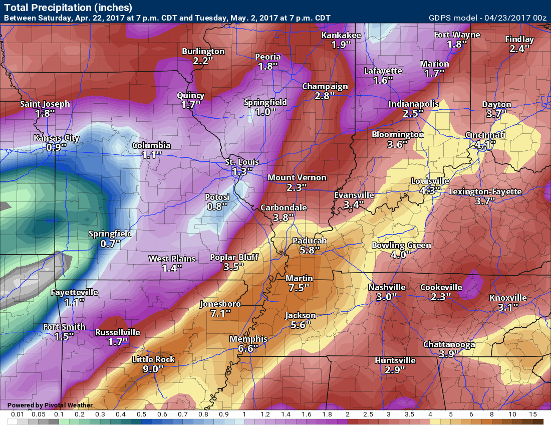
This is for GDPS rainfall through May 2nd.
This is the GFS now through May 9th
This is the GEM guidance from now through May 3rd.
The active pattern has returned. We have been in this pattern for several months.
Monitor updates this week concerning severe weather potential. It is spring, after all.
.

Find me on Twitter

We have regional radars and local city radars – if a radar does not update then try another one. Occasional browsers need their cache cleared. You may also try restarting your browser. That usually fixes the problem. Occasionally we do have a radar go down. That is why I have duplicates. Thus, if one fails then try another one.
During the winter you can track snow and ice by clicking the winterize button on the local city view interactive radars.
If you have any problems then please send me an email beaudodson@usawx.com
Interactive Weather Radar Page. Choose the city nearest your location: Click this link—
National interactive radar: Click this link.
Local interactive city radars include St Louis, Mt Vernon, Evansville, Poplar Bluff, Cape Girardeau, Marion, Paducah, Hopkinsville, Memphis, Nashville, Dyersburg, and all of eastern Kentucky. These are interactive radars. Local city radars – click here
Regional Radar

The official 6-10 day and 8-14 day temperature and precipitation outlook. Check the date stamp at the top of each image (so you understand the time frame).
The forecast maps below are issued by the Weather Prediction Center (NOAA)


The latest 8-14 day temperature and precipitation outlook. Note the dates are at the top of the image. These maps DO NOT tell you how high or low temperatures or precipitation will be. They simply give you the probability as to whether temperatures or precipitation will be above or below normal.


The Beau Dodson Weather APP is ready for Apple and Android users. The purpose of this app is for me to deliver your text messages instantly. ATT and Verizon have not always been reliable when it comes to speed. The app allows instant delivery.
Some of you have asked if you can keep receiving the texts on your phone and the app. The answer to that is, yes. The Android app will automatically allow that to happen. On the Apple app, however, you will need to go into your app and click settings. Make sure the green tab is OFF. Off means you will still receive the texts to your phone and the app. If you have any questions, then email me at beaudodson@usawx.com
The app is for text subscribers.
The direct download, for the Apple app, can be viewed here
https://itunes.apple.com/us/app/id1190136514
If you have not signed up for the texting service then you may do so at www.beaudodsonweather.com

The Android app is also ready.
Remember, the app’s are for www.weathertalk.com subscribers. The app allows your to receive the text messages faster than ATT and Verizon.
Here is the download link for the Android version Click Here

——————————————————–
If you have not signed up for the texts messages, then please do. Link www.beaudodsonweather.com
Your support helps with the following:

and


Who do you trust for your weather information and who holds them accountable?
I have studied weather in our region since the late 1970’s. I have 39 years of experience in observing our regions weather patterns. My degree is in Broadcast Meteorology and a Bachelor’s of Science.
My resume includes:
Member of the American Meteorological Society.
NOAA Weather-Ready Nation Ambassador.
Meteorologist for McCracken County Emergency Management. I served from 2005 through 2015.
Meteorologist for McCracken County Rescue. 2015 through current
I own and operate the Southern Illinois Weather Observatory.
I am the chief meteorologist for Weather Talk LLC. I am the owner of Weather Talk LLC.
I am also a business owner in western Kentucky.
Recipient of the Mark Trail Award, WPSD Six Who Make A Difference Award, Kentucky Colonel, and the Caesar J. Fiamma” Award from the American Red Cross.
In 2005 I helped open the largest American Cross shelter in U.S. history in Houston, Texas. I was deployed to help after Hurricane Katrina and Hurricane Rita. I was a shelter manager of one of the Houston, Texas shelter divisions.
In 2009 I was presented with the Kentucky Office of Highway Safety Award.
Recognized by the Kentucky House of Representatives for my service to the State of Kentucky leading up to several winter storms and severe weather outbreaks.
If you click on the image below you can read the Kentucky House of Representatives Resolution.

I am also President of the Shadow Angel Foundation which serves portions of western Kentucky and southern Illinois.
There is a lot of noise on the internet. A lot of weather maps are posted without explanation. Over time you should learn who to trust for your weather information.
My forecast philosophy is simple and straight forward.
- Communicate in simple terms
- To be as accurate as possible within a reasonable time frame before an event
- Interact with you on Twitter, Facebook, email, texts, and this blog
- Minimize the “hype” that you might see on some television stations or through other weather sources
- Push you towards utilizing wall-to-wall LOCAL TV coverage during severe weather events
Many of the graphics on this page are from www.weatherbell.com
WeatherBell is a great resource for weather model guidance.


You can sign up for my AWARE email by clicking here I typically send out AWARE emails before severe weather, winter storms, or other active weather situations. I do not email watches or warnings. The emails are a basic “heads up” concerning incoming weather conditions