

This forecast update covers far southern Illinois, far southeast Missouri, and far western Kentucky. See the coverage map on the right side of the blog
April 19, 2017
Wednesday Night Forecast Details:
Forecast: Mostly clear to partly cloudy. Isolated storm possible east of Land Between the Lakes.
Temperatures: MO ~ 62 to 65 IL ~ 62 to 65 KY ~ 62 to 65 TN ~ 62 to 65
Winds: South and southwest at 6 to 12 mph. Winds may become gusty overnight with gusts above 20 mph.
My confidence in the forecast verifying: Medium. Some adjustments are possible.
What impacts are anticipated from the weather? Wet roadways. Perhaps lightning east of LBL. Most of the region will remain dry and rain free.
Is severe weather expected? No
The NWS defines severe weather as 58 mph winds or great, 1″ hail or larger, and/or tornadoes
What is the chance of precipitation? MO ~ 10% IL ~ 10% KY ~ 20% TN ~ 20%
Coverage of precipitation: Isolated (if anything at all)
Should I cancel my outdoor plans? No, but check radars in case a few evening storms develop east of LBL (Pennyrile area of western Kentucky)
.
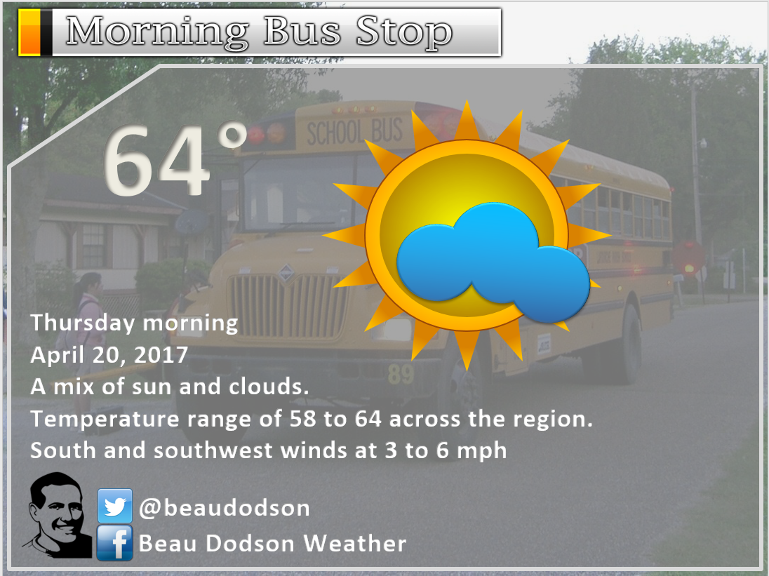
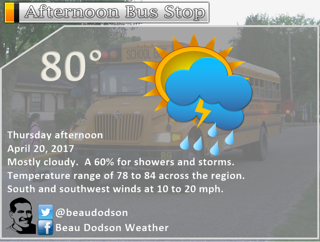
April 20, 2017
Thursday Forecast Details
Forecast: Partly sunny during the morning. Becoming cloudy through the day. Warm. An increasing chance for showers and thunderstorms during the afternoon. Precipitation will move in from the north/northwest and spread south/southeast. Morning hours will have slight chances of precipitation. The band of showers and storms will increase during the afternoon and evening hours.
Temperatures: MO ~ 78 to 82 IL ~ 76 to 82 KY ~ 78 to 82 TN ~ 78 to 84
Winds: South and southwest at 7 to 14 mph with gusts to 24 mph.
What impacts are anticipated from the weather? Wet roadways. Lightning. Monitor updates concerning strong storms.
My confidence in the forecast verifying: High. This forecast should verify.
Is severe weather expected? A few strong storms possible. Isolated severe weather risk during the afternoon and evening hours.
The NWS defines severe weather as 58 mph winds or great, 1″ hail or larger, and/or tornadoes
What is the chance of precipitation? MO ~ 70% IL ~ 70% KY ~ 70% TN ~ 70%
Coverage of precipitation: Scattered to perhaps numerous.
Should I cancel my outdoor plans? No, but monitor updated forecasts and radars. Increasing rain chances during the afternoon and evening.
Sunrise will be at 6:11 a.m. and sunset will be at 7:34 p.m.
Thursday Night Forecast Details:
Forecast: Cloudy. Showers and thunderstorms. Locally heavy rain possible. Strong storms possible with gusty winds and small hail. Lightning, as well. Rain may end over our northern counties, but continue over the southern half of the region as a front stalls near the KY/TN border.
Temperatures: MO ~ 52 to 58 IL ~ 52 to 56 KY ~ 52 to 58 TN ~ 54 to 58
Winds: Becoming west and then north and northwest at 4 to 8 mph with gusts to 15 mph. Winds may change to north and northeast late at night.
My confidence in the forecast verifying: High. This forecast should verify.
What impacts are anticipated from the weather? Wet roadways. Perhaps lightning.
Is severe weather expected? Monitor updates. Strong storms are possible. Locally heavy rain, as well. Isolated severe risk.
The NWS defines severe weather as 58 mph winds or great, 1″ hail or larger, and/or tornadoes
What is the chance of precipitation? MO ~ 60% IL ~ 60% KY ~ 80% TN ~ 80%
Coverage of precipitation: Perhaps numerous.
Should I cancel my outdoor plans? Have a plan B. Rain is likely.
.
April 21, 2017
Friday Forecast Details
Forecast: Cloudy. Cooler. Periods of showers. Thunderstorms possible.
Temperatures: MO ~ 60 to 66 IL ~ 60 to 66 KY ~ 62 to 68 TN ~ 62 to 68
Winds: Northeast and east at 8 to 16 mph. Gusty, at times.
What impacts are anticipated from the weather? Wet roadways. Lightning.
My confidence in the forecast verifying: Medium. Some adjustments are possible.
Is severe weather expected? No
The NWS defines severe weather as 58 mph winds or great, 1″ hail or larger, and/or tornadoes
What is the chance of precipitation? MO ~ 60% IL ~ 60% KY ~ 60% TN ~ 60%
Coverage of precipitation: Scattered to perhaps numerous.
Should I cancel my outdoor plans? Have a plan B. Rain is possible.
Sunrise will be at 6:10 a.m. and sunset will be at 7:35 p.m.
Friday Night Forecast Details:
Forecast: Cloudy. Showers likely. Some thunderstorms are possible.
Temperatures: MO ~ 48 to 56 IL ~ 48 to 56 KY ~ 50 to 55 TN ~ 54 to 60
Winds: East and northeast at 8 to 16 mph with gusts above 20 mph.
My confidence in the forecast verifying: Medium. Some adjustments are possible.
What impacts are anticipated from the weather? Wet roadways. Perhaps lightning.
Is severe weather expected? No
The NWS defines severe weather as 58 mph winds or great, 1″ hail or larger, and/or tornadoes
What is the chance of precipitation? MO ~ 70% IL ~ 70% KY ~ 70% TN ~ 70%
Coverage of precipitation: Perhaps numerous.
Should I cancel my outdoor plans? Have a plan B. Rain is likely.
.
April 22, 2017
Saturday Forecast Details
Forecast: Cloudy. Chilly. Widespread rain. Some thunderstorms possible. Locally heavy rain. A few strong storms possible for the Missouri Bootheel, northwest Tennessee, and along the Kentucky/Tennessee border. Wide range of temperatures from north to south.
Temperatures: MO ~ 52 to 66 (cooler north vs south) IL ~ 52 to 58 KY ~ 58 to 64 TN ~ 60 to 66
Winds: Winds will vary depending on your location in the area in relation to the track of the area of low pressure. North of the low the winds will be out of the east. South of the low winds will be from the south. Wind speeds of 15 to 30 mph. Winds will calm as the low passes overhead.
What impacts are anticipated from the weather? Wet roadways. Lightning. Downpours. Monitor updates concerning thunderstorms. A few strong storms possible south of the warm front.
My confidence in the forecast verifying: Medium. Some adjustments are possible.
Is severe weather expected? Monitor updates. If the low tracks far enough north then some strong storms will be possible.
The NWS defines severe weather as 58 mph winds or great, 1″ hail or larger, and/or tornadoes
What is the chance of precipitation? MO ~ 80% IL ~ 80% KY ~ 80% TN ~ 80%
Coverage of precipitation: Widespread
Should I cancel my outdoor plans? Have alternative plans. At this time, rain appears likely. Plan for rain and hope for the best.
Sunrise will be at 6:09 a.m. and sunset will be at 7:36 p.m.
Saturday Night Forecast Details:
Forecast: Cloudy. Showers likely before midnight. Chilly. Breezy, at times.
Temperatures: MO ~ 44 to 48 IL ~ 44 to 47 KY ~ 44 to 47 TN ~ 44 to 47
Winds: Winds becoming north and northwest at 10 to 20 mph. Gusty winds.
My confidence in the forecast verifying: Medium. Some adjustments are possible.
What impacts are anticipated from the weather? Wet roadways. Perhaps lightning.
Is severe weather expected? No
The NWS defines severe weather as 58 mph winds or great, 1″ hail or larger, and/or tornadoes
What is the chance of precipitation? MO ~ 60% IL ~ 70% KY ~ 80% TN ~ 80%
Coverage of precipitation: Perhaps numerous before midnight. Scattered after midnight.
Should I cancel my outdoor plans? Have alternative plans. It may rain.
.
April 23, 2017
Sunday Forecast Details
Forecast: Partly cloudy. Cooler. I can’t rule out a shower behind our weekend storm system. Wrap around clouds are possible. Some question on cloud coverage.
Temperatures: MO ~ 62 to 66 IL ~ 62 to 66 KY ~ 62 to 66 TN ~ 62 to 66
Winds: Northerly winds at 10 to 20 mph with higher gusts possible.
What impacts are anticipated from the weather? Possible some wet roadways. It might remain dry on Sunday, but a few wrap-around showers are possible.
My confidence in the forecast verifying: Medium. Some adjustments are possible.
Is severe weather expected? No
The NWS defines severe weather as 58 mph winds or great, 1″ hail or larger, and/or tornadoes
What is the chance of precipitation? MO ~ 10% IL ~ 20% KY ~ 20% TN ~ 10%
Coverage of precipitation: None to isolated
Should I cancel my outdoor plans? No
Sunrise will be at 6:07 a.m. and sunset will be at 7:37 p.m.
Sunday Night Forecast Details:
Forecast: Clear and chilly.
Temperatures: MO ~ 44 to 48 IL ~ 44 to 48 KY ~ 44 to 48 TN ~ 44 to 48
Winds: North and northeast winds at 6 to 12 mph.
My confidence in the forecast verifying: Medium. Some adjustments are possible.
What impacts are anticipated from the weather? None
Is severe weather expected? No
The NWS defines severe weather as 58 mph winds or great, 1″ hail or larger, and/or tornadoes
What is the chance of precipitation? MO ~ 0% IL ~ 0% KY ~ 0% TN ~ 0%
Coverage of precipitation: None.
Should I cancel my outdoor plans? No
.
and
.
.

Don’t forget to check out the Southern Illinois Weather Observatory web-site for weather maps, tower cams, scanner feeds, radars, and much more! Click here

An explanation of what is happening in the atmosphere over the coming day

Severe thunderstorm outlook.
Remember that a severe thunderstorm is defined as a thunderstorm that produces 60 mph winds or higher, quarter size hail or larger, and/or a tornado.
Wednesday night: A slight chance for a thunderstorm in west Tennessee and areas to the east of LBL Even smaller chances, elsewhere. Lightning is the concern.
Thursday and Thursday night: A cold front moves into the local area. A band of showers and thunderstorms will accompany the front. Wind fields will be stronger with this system compared to the last. I can’t completely rule out severe weather, but the chances will probably be small. Lightning will be a concern for outdoor events. Monitor updates.
Friday through Sunday: Another system will move through the area on Friday into the weekend. The track of the area of low pressure will be key to our weather conditions. If the low tracks to the north then strong storms are possible. If the low tracks to our south then thunderstorms are possible, but severe weather concerns would be minimal.
At this time, it appears the greater risk for severe weather will remain to our south.
Monitor updates concerning the weekend storm system.
———————————
Weather analysis for the next few days:
Wednesday night:
A mild night ahead of us. Expect lows in the sixties.
There will probably be a couple of showers and storms over the Pennyrile area of western Kentucky before 8 pm. Showers and storms will diminish after sunset. Other areas will remain dry.
Some gusty winds from time to time.
Thursday into the weekend:
An active pattern is unfolding for Thursday, Friday, and Saturday. If you have outdoor plans, during this time period, then you will want to monitor updated information. Several periods of showers and storms are likely to occur. Some of the rain will be locally heavy.
A cold front will move into the region on Thursday and Thursday night. This front will move in from the north and spread southward.
Showers and thunderstorms are forecast to develop along and ahead of the cold front. Some of the storms could produce gusty winds, lightning, small hail, and downpours.
The best chance for showers and storms will be during the afternoon and evening hours.
The front will become stationary (stall out) near the Kentucky and Tennessee border. This means showers and thunderstorm chances will remain with us into Friday night.
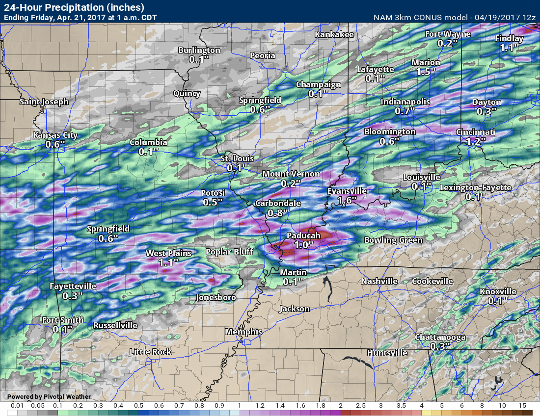
Here is the forecast rainfall totals for Thursday (from the NAM guidance). Remember, this is just one models opinion on what might happen. Models vary on totals.
Rainfall totals on Thursday will likely vary. If thunderstorms form then locally heavier totals will occur. At this time, I will forecast 0.25″ to 0.50″ of rain. Again, thunderstorms can easily double those numbers.
If some of the guidance is correct then a few spots may miss out on measurable rainfall. Let’s monitor updates. Plan on precipitation showing up on radar Thursday into Thursday night.
Don’t take this literally. It is a model. Take the general idea.
See the bigger totals? That would be because of thunderstorms. The placement of storms will determine who ends up with larger rainfall totals.
This is through 1 am on Friday.
Additional ripples of energy will move along the stationary front on Friday into Friday night. That means periods of showers and thunderstorms. Locally heavy rain is a concern. There will be plenty of moisture associated with this system.
I am anticipating widespread one to two inches of rain between Thursday and Saturday night. Some areas will receive more.
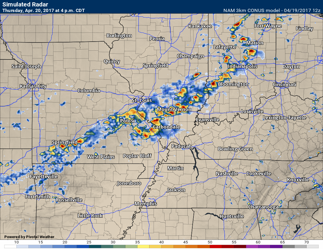
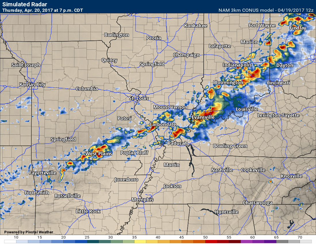
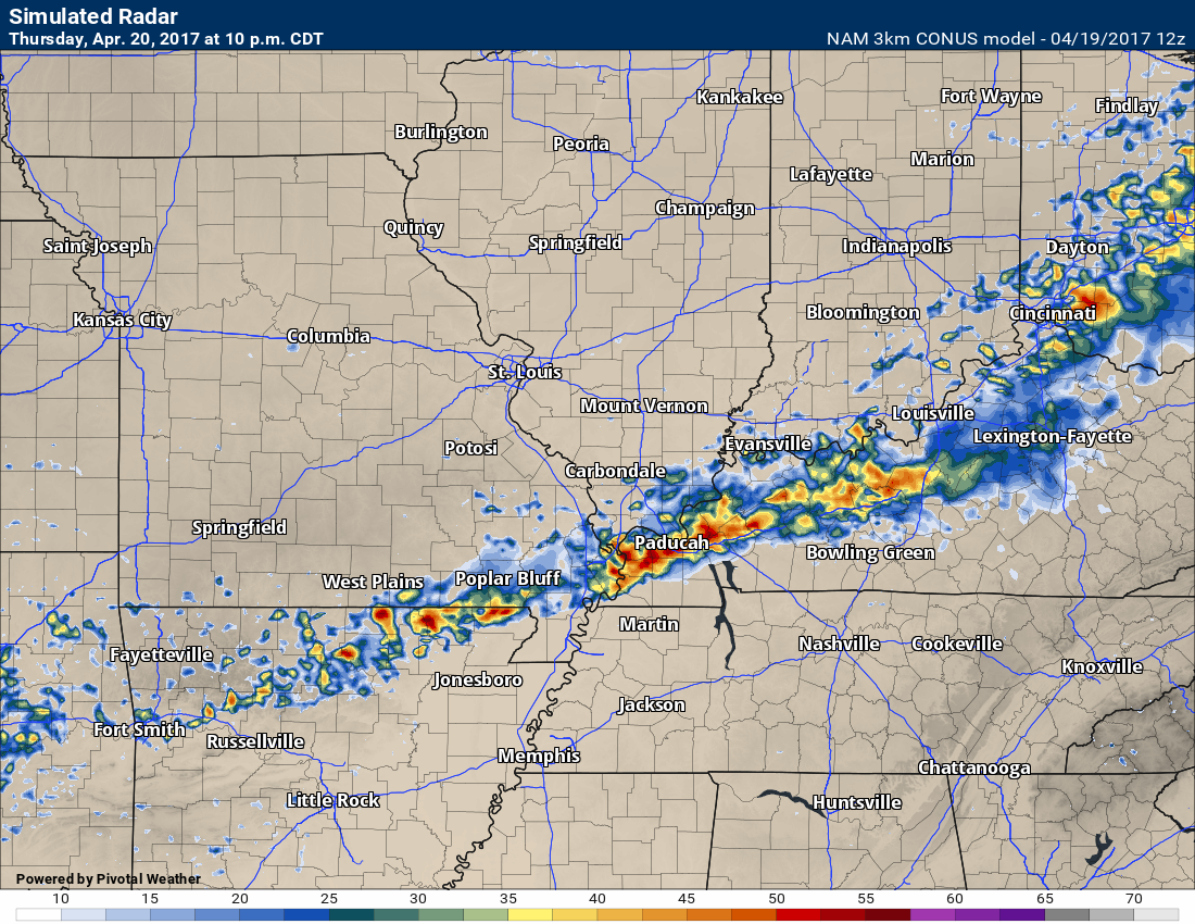
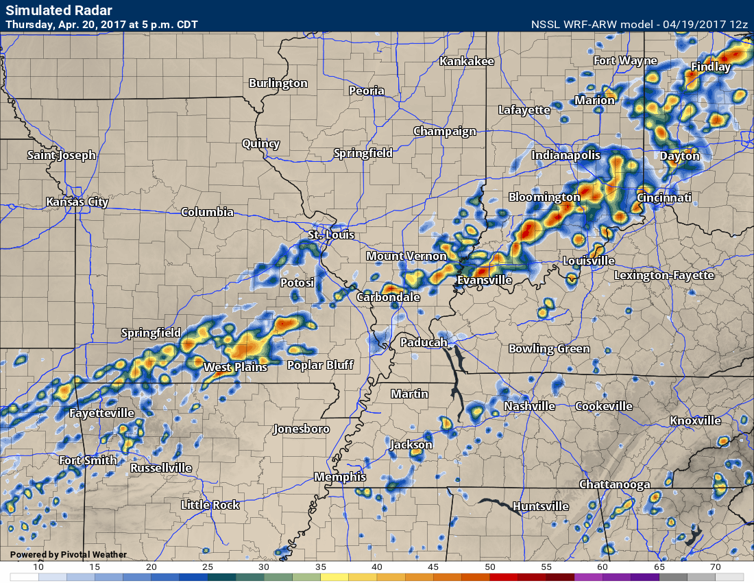
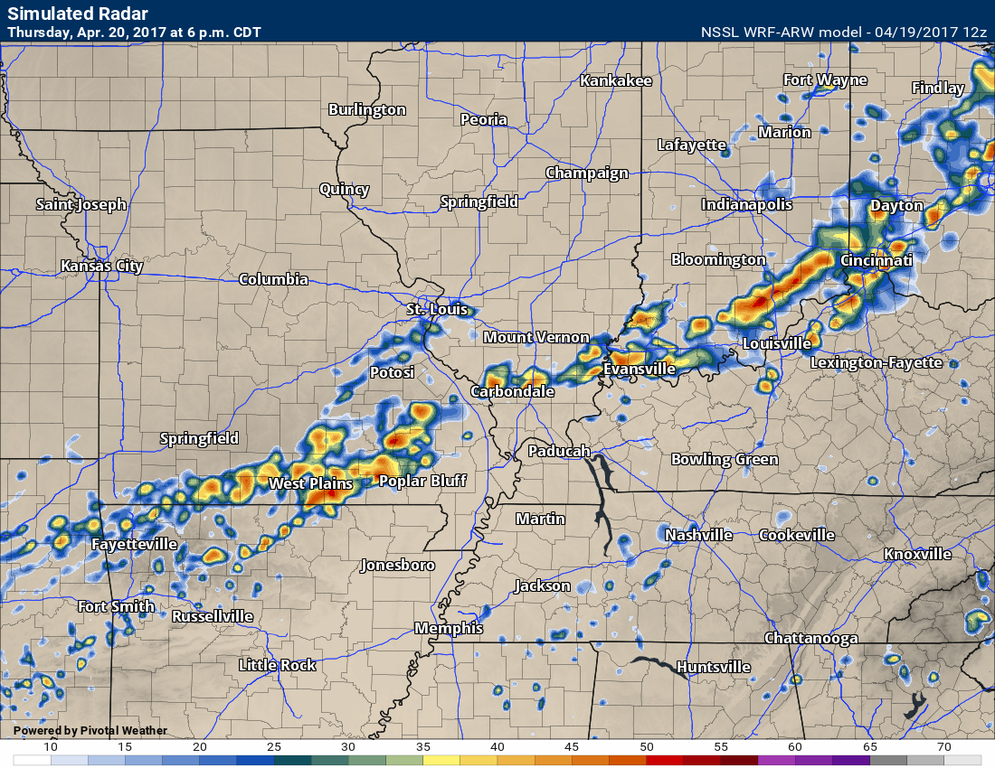
Let’s look at future-cast radar for Thursday and Thursday night. This is the high resolution 3K NAM guidance. It won’t be exact, but this is the idea it has.
This first image is for 4 pm on Thursday.
This next image is for 7 pm on Thursday
This next image is for 10 pm on Thursday
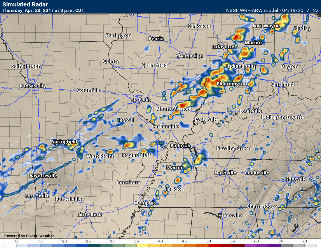
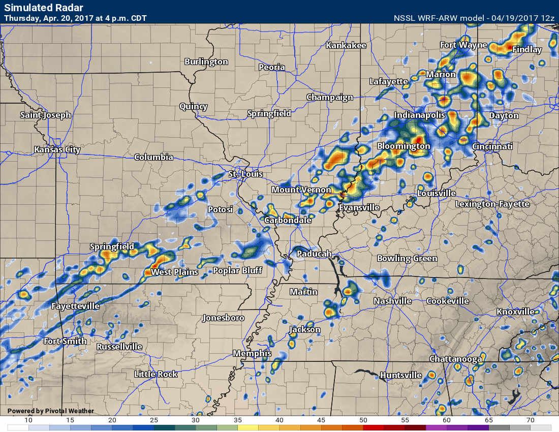
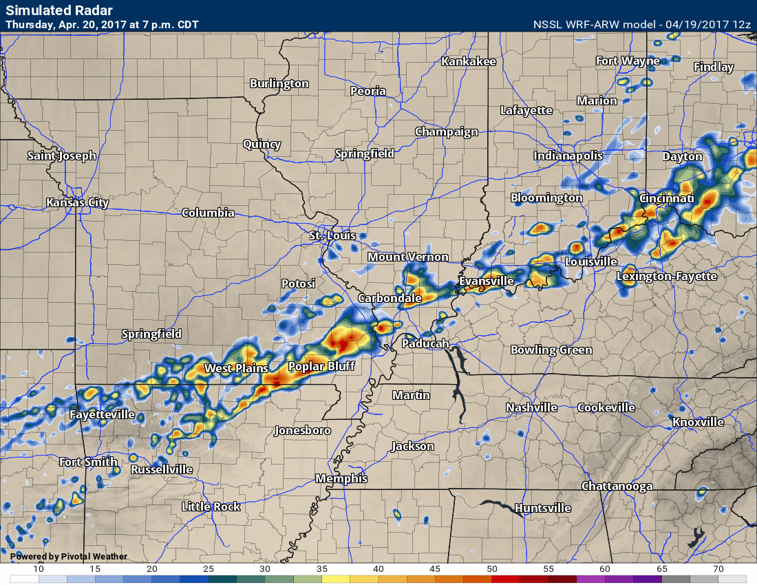
Let’s look at another model. I like this model. This is the SPC WRF guidance. It is a high resolution model and does quite well with thunderstorms.
Here is the 3 pm future-cast radar for Thursday
4 pm Thursday
5 pm Thursday
6 pm Thursday
7 pm Thursday
You get the general idea. A band of showers and storms will form along the cold front and move into our local area. Some of the storms could be strong with gusty winds, hail, lightning, and heavy downpours.
There is at least a marginal risk that a few storms become severe. Hail and high winds would be the main concern. Monitor updates on Thursday afternoon and night. I can’t rule out some severe thunderstorm warnings. I will be utilizing the texting service. Be sure and sign up at www.beaudodsonweather.com
Weekend system:
Friday through Sunday
Locally heavy rain and gusty winds.
The cold front on Thursday will stall out over our local area. The front should become stationary near the Missouri and Arkansas border eastward into Kentucky and Tennessee.
Periods of showers and thunderstorms will develop along this front. Ripples of energy will move from west to east from Kansas and Oklahoma and then into our area.
Some of the rain could be heavy.
If you have outdoor plans on Friday or Saturday, then have a solid plan B. Have alternative indoor plans. It does appear that there will be high rain chances on both days.
The area of low pressure should pass across northern Arkansas on Saturday and then approach the Missouri Bootheel, western Kentucky, and western Tennessee on Saturday afternoon.
The placement of the area of low pressure is important. North of the low we don’t normally have severe weather concerns. South and east of the low is where the warmer air will be situated. This is where storms are possible.
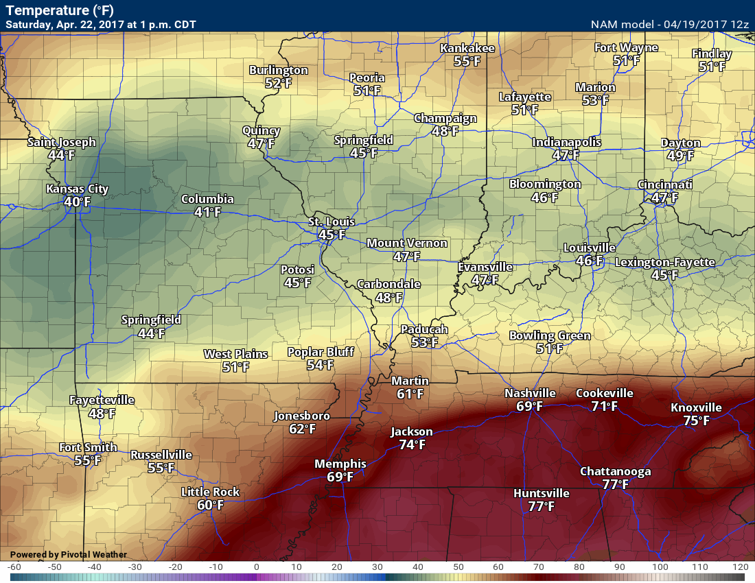
Look at this temperature map for Saturday. There is a front in there! The warm front will be near our area. If you are south of the warm front then thunderstorms are possible.
We will need to monitor the placement of the warm front.
This is 1 pm on Saturday. Again, the exact placement of the warm front is important. This will need to be monitored. If it slightly further north then I will have to introduce greater thunderstorm chances.
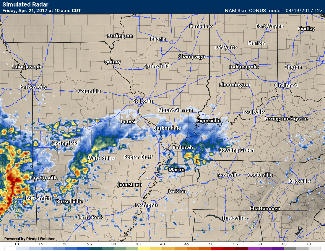
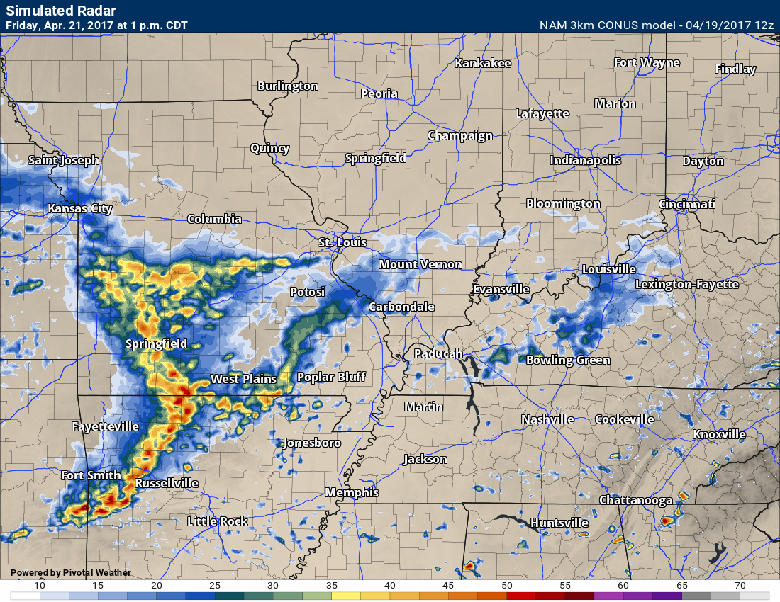
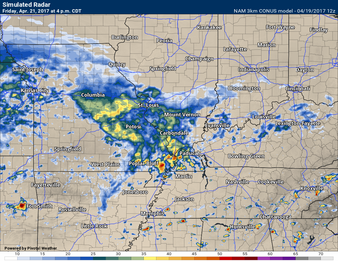
Let’s look at the 3K NAM depiction of showers and storms on Friday.
Again, this is a model and is not gospel. Take the general idea from these graphics.
10 am Friday future-cast radar.
1 pm future-cast radar for Friday
4 pm future-cast radar for Friday
7 pm future-cast radar for Friday
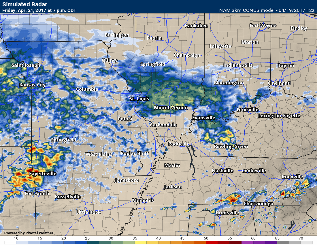
The bottom line is that several rounds of showers and storms will be possible from Thursday afternoon through Saturday night.
Saturday:
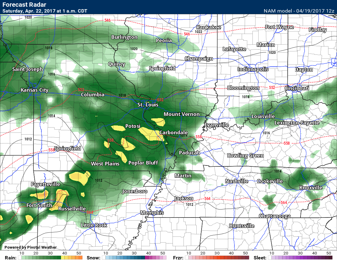
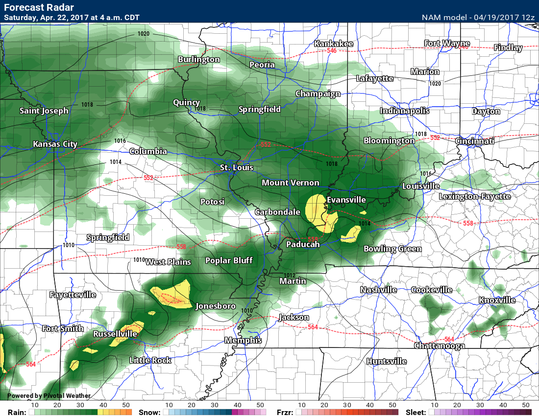
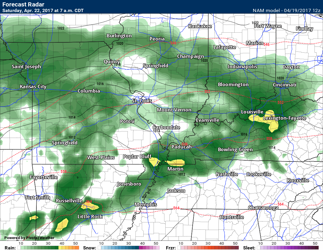
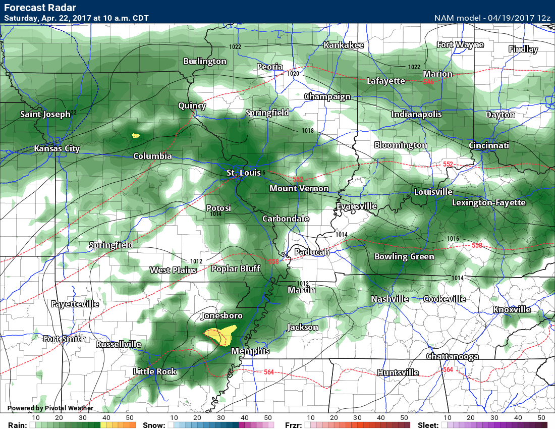
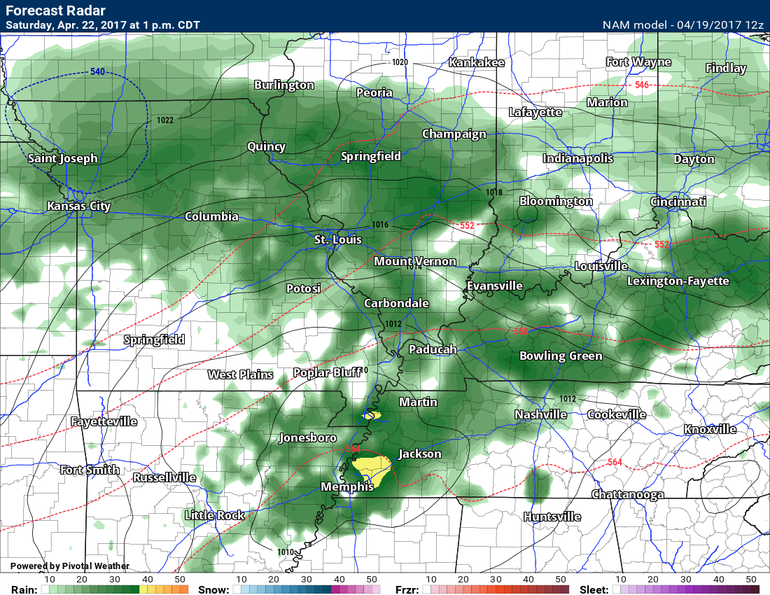
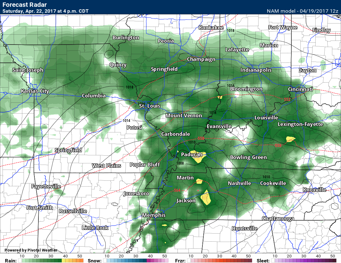
Rain is likely on Saturday. Widespread rain should cover radar.
Future-cast radar from the NAM guidance. I think you get the point. Could there be some breaks in the rain? Maybe, but I would plan on rain. Weddings, run events, and other should take note.
1 am Saturday
Green represents rain. Dark green is heavier rain. Yellow is heavier, yet.
4 am Saturday
7 am Saturday
10 am Saturday
1 pm Saturday
4 pm Saturday
7 pm Saturday
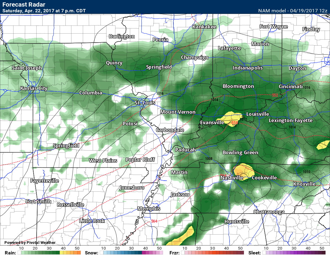
You get the idea.
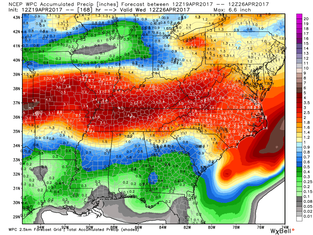
Let’s look at forecasted rainfall totals.
NOAA totals
Click image to enlarge
GFS model guidance rainfall totals
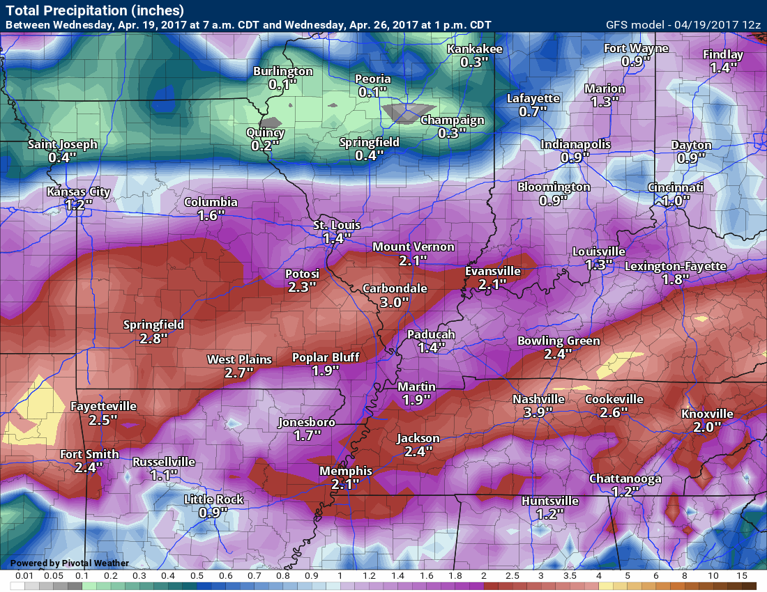
Locally heavy rain is certainly possible.
.

Find me on Twitter

We have regional radars and local city radars – if a radar does not update then try another one. Occasional browsers need their cache cleared. You may also try restarting your browser. That usually fixes the problem. Occasionally we do have a radar go down. That is why I have duplicates. Thus, if one fails then try another one.
During the winter you can track snow and ice by clicking the winterize button on the local city view interactive radars.
If you have any problems then please send me an email beaudodson@usawx.com
Interactive Weather Radar Page. Choose the city nearest your location: Click this link—
National interactive radar: Click this link.
Local interactive city radars include St Louis, Mt Vernon, Evansville, Poplar Bluff, Cape Girardeau, Marion, Paducah, Hopkinsville, Memphis, Nashville, Dyersburg, and all of eastern Kentucky. These are interactive radars. Local city radars – click here
Regional Radar

The official 6-10 day and 8-14 day temperature and precipitation outlook. Check the date stamp at the top of each image (so you understand the time frame).
The forecast maps below are issued by the Weather Prediction Center (NOAA)


The latest 8-14 day temperature and precipitation outlook. Note the dates are at the top of the image. These maps DO NOT tell you how high or low temperatures or precipitation will be. They simply give you the probability as to whether temperatures or precipitation will be above or below normal.


The Beau Dodson Weather APP is ready for Apple and Android users. The purpose of this app is for me to deliver your text messages instantly. ATT and Verizon have not always been reliable when it comes to speed. The app allows instant delivery.
Some of you have asked if you can keep receiving the texts on your phone and the app. The answer to that is, yes. The Android app will automatically allow that to happen. On the Apple app, however, you will need to go into your app and click settings. Make sure the green tab is OFF. Off means you will still receive the texts to your phone and the app. If you have any questions, then email me at beaudodson@usawx.com
The app is for text subscribers.
The direct download, for the Apple app, can be viewed here
https://itunes.apple.com/us/app/id1190136514
If you have not signed up for the texting service then you may do so at www.beaudodsonweather.com

The Android app is also ready.
Remember, the app’s are for www.weathertalk.com subscribers. The app allows your to receive the text messages faster than ATT and Verizon.
Here is the download link for the Android version Click Here

——————————————————–
If you have not signed up for the texts messages, then please do. Link www.beaudodsonweather.com
Your support helps with the following:

and


Who do you trust for your weather information and who holds them accountable?
I have studied weather in our region since the late 1970’s. I have 39 years of experience in observing our regions weather patterns. My degree is in Broadcast Meteorology and a Bachelor’s of Science.
My resume includes:
Member of the American Meteorological Society.
NOAA Weather-Ready Nation Ambassador.
Meteorologist for McCracken County Emergency Management. I served from 2005 through 2015.
Meteorologist for McCracken County Rescue. 2015 through current
I own and operate the Southern Illinois Weather Observatory.
I am the chief meteorologist for Weather Talk LLC. I am the owner of Weather Talk LLC.
I am also a business owner in western Kentucky.
Recipient of the Mark Trail Award, WPSD Six Who Make A Difference Award, Kentucky Colonel, and the Caesar J. Fiamma” Award from the American Red Cross.
In 2005 I helped open the largest American Cross shelter in U.S. history in Houston, Texas. I was deployed to help after Hurricane Katrina and Hurricane Rita. I was a shelter manager of one of the Houston, Texas shelter divisions.
In 2009 I was presented with the Kentucky Office of Highway Safety Award.
Recognized by the Kentucky House of Representatives for my service to the State of Kentucky leading up to several winter storms and severe weather outbreaks.
If you click on the image below you can read the Kentucky House of Representatives Resolution.

I am also President of the Shadow Angel Foundation which serves portions of western Kentucky and southern Illinois.
There is a lot of noise on the internet. A lot of weather maps are posted without explanation. Over time you should learn who to trust for your weather information.
My forecast philosophy is simple and straight forward.
- Communicate in simple terms
- To be as accurate as possible within a reasonable time frame before an event
- Interact with you on Twitter, Facebook, email, texts, and this blog
- Minimize the “hype” that you might see on some television stations or through other weather sources
- Push you towards utilizing wall-to-wall LOCAL TV coverage during severe weather events
Many of the graphics on this page are from www.weatherbell.com
WeatherBell is a great resource for weather model guidance.


You can sign up for my AWARE email by clicking here I typically send out AWARE emails before severe weather, winter storms, or other active weather situations. I do not email watches or warnings. The emails are a basic “heads up” concerning incoming weather conditions