WeatherTalk monthly operating costs can top $2000.00. Your $3 subscription helps pay for those costs. I work for you.
For $3 a month you can receive the following. You may choose to receive these via your WeatherTalk app or regular text messaging.
- Severe weather app/text alerts from my keyboard to your app/cell phone. These are hand typed by Beau. During tornado outbreaks, you will receive numerous app/text messages telling you exactly where the tornado is located.
- Daily forecast app/texts from my computer to your app/cell phone.
- Social media links sent directly to your app/cell phone. When I update the blog, videos, or Facebook you will receive the link.
- AWARE emails. These emails keep you well ahead of the storm. They give you several days of lead time before significant weather events.
- Direct access to Beau via text and email. Your very own personal meteorologist. I work for you!
- Missouri and Ohio Valley centered video updates
- Long-range weather videos
- Week one, two, three and four temperature and precipitation outlooks.
- Monthly outlooks.
- Your subscription also will help support several local charities.
Haven’t you subscribed? Subscribe at www.beaudodsonweather.com

Example of a recent severe weather alert. I issued this well before the official tornado warning. You would have had plenty of time for you and your family to seek shelter.


Your $3 per month also helps support these local charity projects.

I encourage subscribers to use the app vs regular text messaging. We have found text messaging to be delayed during severe weather. The app typically will receive the messages instantly. I recommend people have three to four methods of receiving their severe weather information.
Remember, my app and text alerts are hand typed and not computer generated. You are being given personal attention during significant weather events.

WWW.WEATHERTALK.COM subscribers, here is my day to day schedule for your weather products.


April 17, 2018
Tuesday Forecast Details
Forecast: Morning frost. Mostly sunny. Milder.
Temperatures: MO ~ 65 (north) to 70 (Poplar Bluff area) IL ~ 58 (north) to 66 (south) KY ~ 60 (NW KY) to 68 (SW KY) TN ~ 68 to 72
What is the chance of precipitation? MO ~ 0% IL ~ 0% KY ~ 0% TN ~ 0%
Coverage of precipitation: None
Winds: South and southwest at 5 to 10 mph
What impacts are anticipated from the weather? None
My confidence in the forecast verifying: High
Is severe weather expected? No
The NWS defines severe weather as 58 mph wind or great, 1″ hail or larger, and/or tornadoes
Should I cancel my outdoor plans? No
Sunrise: 6:17 AM
Tuesday Night Forecast Details:
Forecast: Increasing clouds.
Temperatures: MO ~ 53 to 56 IL ~ 45 (Mt Vernon area) to 55 KY ~ 53 to 56 TN ~ 54 to 58
What is the chance of precipitation? MO ~ 0% IL ~ 0% KY ~ 0% TN ~ 0%
Coverage of precipitation: None
Winds: South and southwest at 5 to 10 mph early increasing to 7 to 14 mph and gusty after 3 AM
What impacts are anticipated from the weather? None
My confidence in the forecast verifying: High
Is severe weather expected? No
The NWS defines severe weather as 58 mph wind or great, 1″ hail or larger, and/or tornadoes
Should I cancel my outdoor plans? No
Sunset: 7:31 PM
April 18, 2018
Wednesday Forecast Details
Forecast: Partly sunny. Windy. A slight chance of a light shower over southern Illinois and western Kentucky. Mild temperatures.
Temperatures: MO ~ 72 to 75 IL ~ 68 to 75 KY ~ 70 to 75 TN ~ 72 to 76
What is the chance of precipitation? MO ~ 10% IL ~ 20% KY ~ 20% TN ~ 5%
Coverage of precipitation: None to isolated
Winds: Southwest at 8 to 16 mph with gusts to 30 (higher gusts possible)
What impacts are anticipated from the weather? strong winds.
My confidence in the forecast verifying: High
Is severe weather expected? No
The NWS defines severe weather as 58 mph wind or great, 1″ hail or larger, and/or tornadoes
Should I cancel my outdoor plans? No
Sunrise: 6:16 AM
Wednesday Night Forecast Details:
Forecast: Partly cloudy. A slight chance of a shower early. Cooler.
Temperatures: MO ~ 38 to 44 IL ~ 38 to 44 KY ~ 40 to 44 TN ~ 40 to 44
What is the chance of precipitation? MO ~ 10% IL ~ 20% KY ~ 20% TN ~ 10%
Coverage of precipitation: None to isolated. Most areas will remain dry.
Winds: Becoming west at 6 to 12 mph with gusts to 18
What impacts are anticipated from the weather? Most likely none
My confidence in the forecast verifying: High
Is severe weather expected? No
The NWS defines severe weather as 58 mph wind or great, 1″ hail or larger, and/or tornadoes
Should I cancel my outdoor plans? No
Sunset: 7:31 PM
April 19, 2018
Thursday Forecast Details
Forecast: Mostly sunny. Cooler.
Temperatures: MO ~ 54 to 58 IL ~ 54 to 58 KY ~ 54 to 58 TN ~ 58 to 60
What is the chance of precipitation? MO ~ 0% IL ~ 0% KY ~ 0% TN ~ 0%
Coverage of precipitation: None
Winds: Northwest 10 to 20 mph
What impacts are anticipated from the weather? None
My confidence in the forecast verifying: High
Is severe weather expected? No
The NWS defines severe weather as 58 mph wind or great, 1″ hail or larger, and/or tornadoes
Should I cancel my outdoor plans? No
Sunrise: 6:14 AM
Thursday Night Forecast Details:
Forecast: Mostly clear. Cold. Frost possible.
Temperatures: MO ~ 35 to 38 IL ~ 34 to 38 KY ~ 35 to 40 TN ~ 36 to 38
What is the chance of precipitation? MO ~ 0% IL ~ 0% KY ~ 0% TN ~ 0%
Coverage of precipitation: None
Winds: Mostly north at 6 to 12 mph
What impacts are anticipated from the weather? Frost is possible.
My confidence in the forecast verifying: High
Is severe weather expected? No
The NWS defines severe weather as 58 mph wind or great, 1″ hail or larger, and/or tornadoes
Should I cancel my outdoor plans? No
Sunset: 7:32 PM
April 20, 2018
Friday Forecast Details
Forecast: Mostly sunny. Mild.
Temperatures: MO ~ 58 to 62 IL ~ 58 to 62 KY ~ 58 to 64 TN ~ 58 to 64
What is the chance of precipitation? MO ~ 0% IL ~ 0% KY ~ 0% TN ~ 0%
Coverage of precipitation: None
Winds: North and northeast 5 to 10 mph
What impacts are anticipated from the weather? None
My confidence in the forecast verifying: High
Is severe weather expected? No
The NWS defines severe weather as 58 mph wind or great, 1″ hail or larger, and/or tornadoes
Should I cancel my outdoor plans? No
Sunrise: 6:13 AM
Friday Night Forecast Details:
Forecast: Partly cloudy.
Temperatures: MO ~ 40 to 45 IL ~ 38 to 44 KY ~ 40 to 44 TN ~ 42 to 44
What is the chance of precipitation? MO ~ 0% IL ~ 0% KY ~ 0% TN ~ 0%
Coverage of precipitation: None
Winds: Northeast and east at 6 to 12 mph
What impacts are anticipated from the weather? None
My confidence in the forecast verifying: Medium
Is severe weather expected? No
The NWS defines severe weather as 58 mph wind or great, 1″ hail or larger, and/or tornadoes
Should I cancel my outdoor plans? No
Sunset: 7:33 PM
Weekend: Another storm system should approach the region from the south and west. This will likely spread rain into the region. There remain some questions on timing. Saturday may remain mostly dry.
April 21, 2018
Saturday Forecast Details
Forecast: Increasing clouds. A chance of rain late Saturday night. Most of Saturday may remain dry. Monitor updates.
Temperatures: MO ~ 60 to 65 IL ~ 60 to 64 KY ~ 60 to 65 TN ~ 62 to 66
What is the chance of precipitation? MO ~ 0% IL ~ 0% KY ~ 0% TN ~ 0%
My confidence in the forecast verifying: Medium
April 22, 2018
Sunday Forecast Details
Forecast: Cloudy with rain showers over the southern half of the region. Another storm system should approach the region from the south and west. This will likely spread some rain into the region. There remain some questions on timing and coverage. If the system drifts far enough south then portions of the region will remain dry through Sunday. Monitor updates.
Temperatures: MO ~ 60 to 65 IL ~ 60 to 65 60 KY ~ 60 to 65 TN ~ 62 to 66
What is the chance of precipitation? MO ~ 40% IL ~ 30% KY ~ 40% TN ~ 40%
My confidence in the forecast verifying: Medium
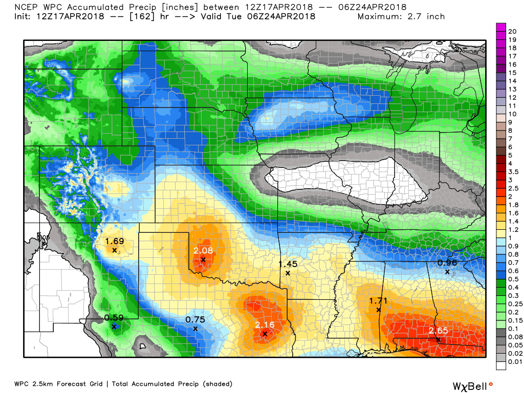
RAIN TOTALS
Rain is unlikely today through Friday night.
A couple of stray showers may occur Wednesday/Wednesday night. I believe most of us remain dry.
Our next chance of rain will be Sunday and Sunday night. This is a southern storm. That places us on the cool side.
Rain totals should be light. Our far northern counties may remain dry from this event. This will depend on the track of the area of low pressure.
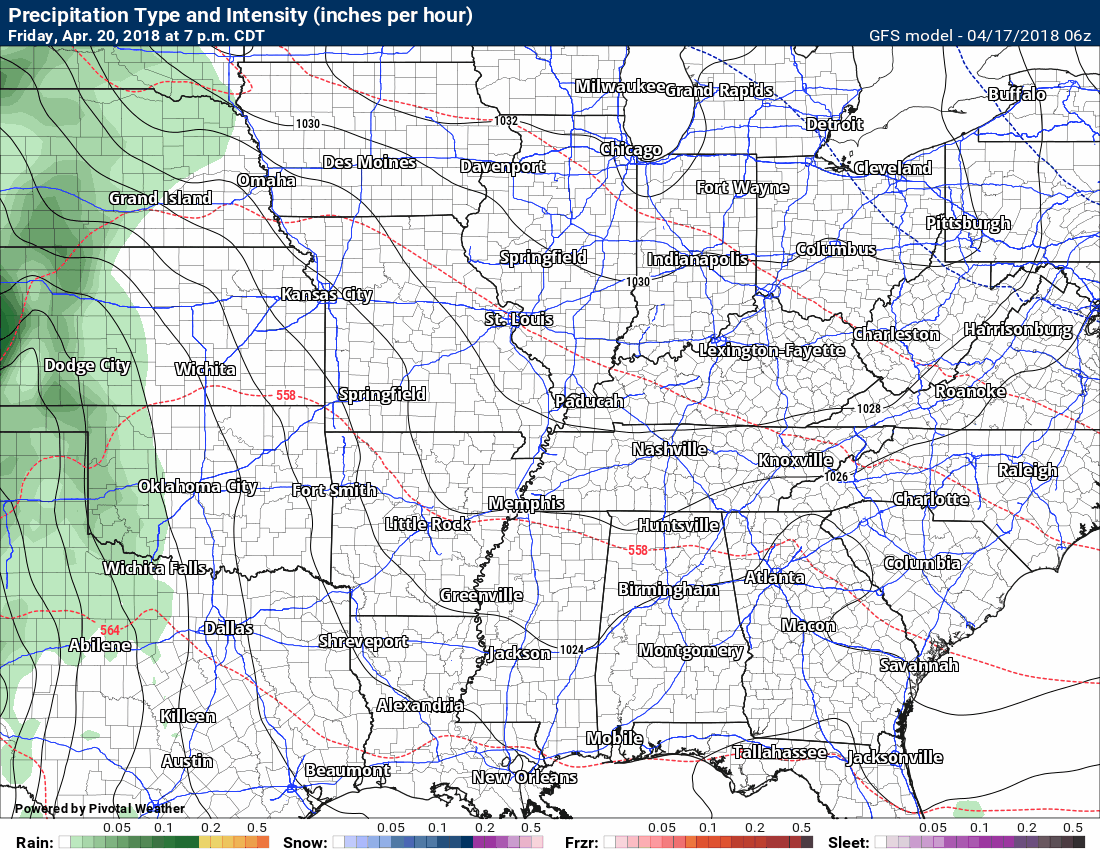
Here is the latest rainfall forecast. All of this falls Sunday and Sunday night.
Monitor updates. If the storm track shifts then so will the forecast.

Interactive Radars:
Interactive live weather radar page. Choose the city nearest your location. If one of the cities does not work then try a nearby one. Click here.

Questions? Broken links? Other?
You may email me at beaudodson@usawx.com

The National Weather Service defines a severe thunderstorm as one that produces quarter size hail or larger, 58 mph winds or greater, and/or a tornado.
Tuesday through Thursday: Severe weather is not anticipated.
Friday into Saturday: Severe weather is not anticipated.
Sunday into Tuesday: Severe weather is unlikely. I will be monitoring Sunday and Sunday night for a possible clap of thunder.
![]()
Interactive live weather radar page. Choose the city nearest your location. If one of the cities does not work then try a nearby one. Click here.
National map of weather watches and warnings. Click here.
Storm Prediction Center. Click here.
Weather Prediction Center. Click here.

Live lightning data: Click here.

Interactive GOES R satellite. Track clouds. Click here.

Here are the latest local river stage forecast numbers Click Here.
Here are the latest lake stage forecast numbers for Kentucky Lake and Lake Barkley Click Here.

The spring and preliminary summer outlooks have been posted for subscribers. Scroll down to see the outlook.
Not a subscriber? Learn more at this link.

Weather Headlines
- Milder today and Wednesday (Wednesday the warmest day)
- Watching weekend rain chances.
The weather remains quiet and that is the good news.
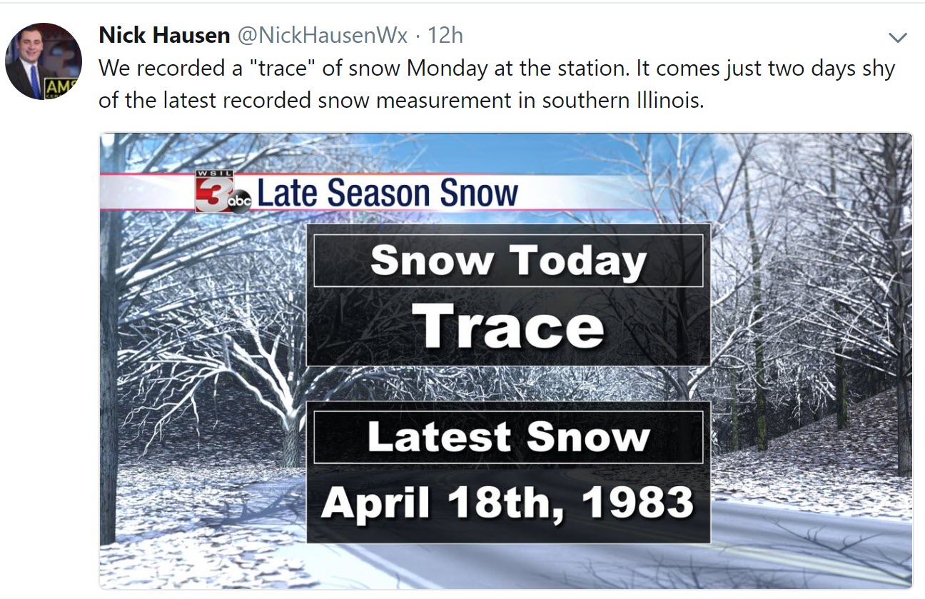
We had numerous snow flurries and snow showers Sunday night and Monday. It was also cold.
Nick Hausen, from WSIL TV 3, posted this stat.
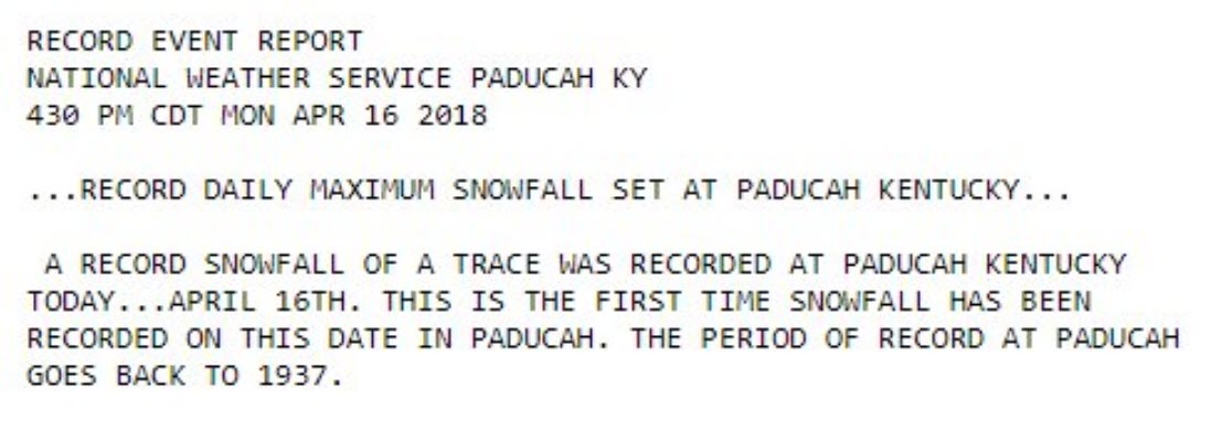
The National Weather Service Office out of Paducah, Kentucky posted these numbers.
Click to enlarge.
And this one from Evansville, Indiana.
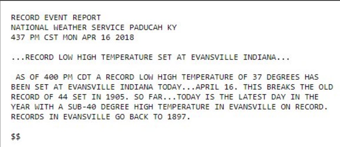
No surprise on the above. We all know it has been cold.
Here is a photograph from Paducah, Kentucky earlier this morning. This was posted by the NWS. Frosty morning.
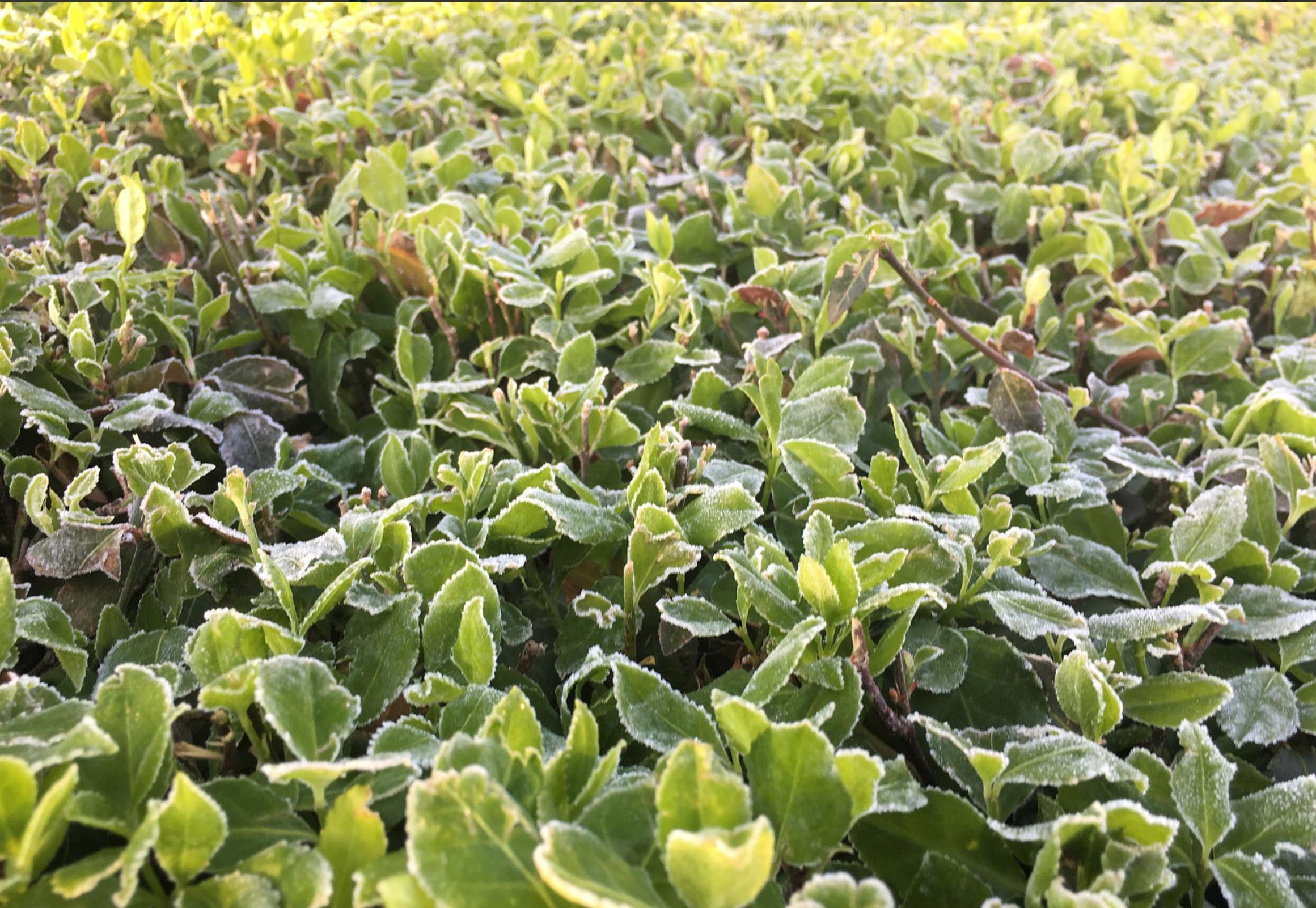
We will have additional frost chances Thursday night as temperatures dip back into the 30’s.
The good news is that today and tomorrow will be milder.
We will have a bit of a temperature range today because of a warm front. Cooler north of the boundary. Warmer south of the boundary.
Here are today’s high-temperature numbers.
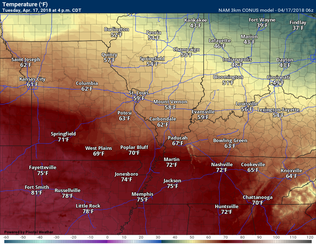
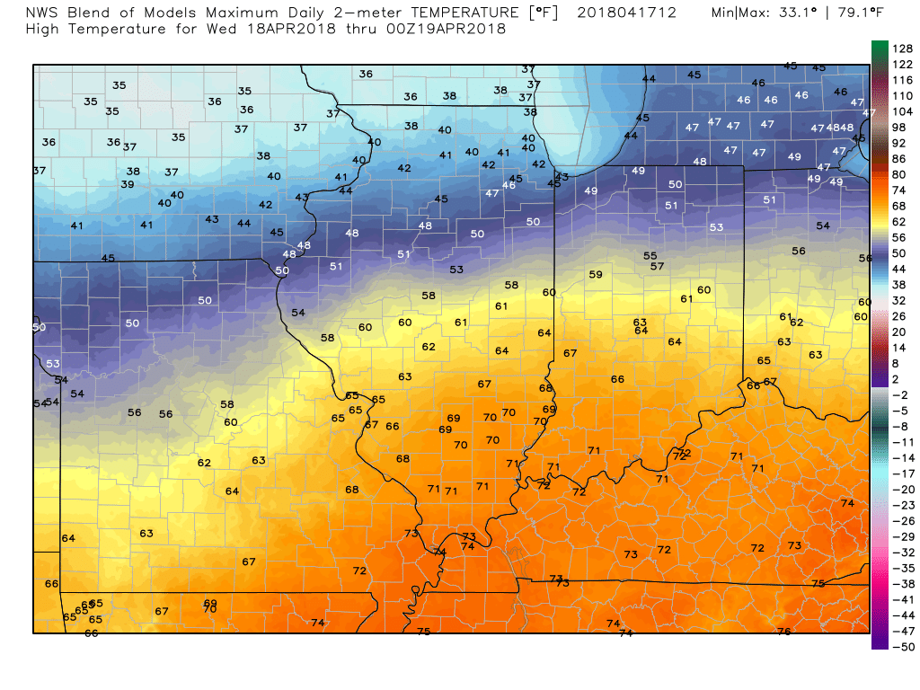
Wednesday will be warmer area-wide! Expect 70’s to be widespread by Wednesday afternoon. A day to enjoy!
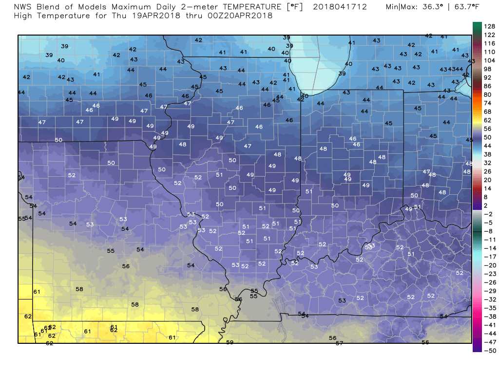
Cooler weather returns by Thursday. Go figure.
Our next decent chance of rain will arrive Sunday and Sunday night. If this system shifts further south then we might avoid most of the rain. Still a bit early to bank on a forecast. For now, I have rain in the cast.
Timestamp upper left.
![]()

Weather Brains is a weekly podcast/video for those who love weather and want more!
Weather Brains episode number 638
Our guest WeatherBrain for this episode is Matt Solum. Matt is the Decision Support Services Program Manager at Western Region Headquarters of the National Weather Service in Salt Lake City, UT. Matt was in the California State Operations Center, basically the state EOC, supporting their full activation as a result of the fires in southern California. Their team was providing forecast information primarily for the California Governor’s Office of Emergency Services (CalOES) and FEMA as it was a joint operation. They also provided weather information to other partners in the room including EPA, CalTrans, DOT, CalEPA, etc. He was deployed to both the October fires and the massive/prolonged December fires. Welcome to WeatherBrains, Matt.
Other discussions in this weekly podcast include topics like:
- Extremes: 101 at Thermal, CA, and 2 at Raco, MI
- Relatively calm weather across US
- Threat for severe wx in Lower Mississippi River Valley on Friday
- Astronomy Outlook with Tony Rice
- and more!
Previous episodes can be viewed by clicking here.

We offer interactive local city live radars and regional radars. If a radar does not update then try another one. If a radar does not appear to be refreshing then hit Ctrl F5. You may also try restarting your browser.
The local city view radars also have clickable warnings.
During the winter months, you can track snow and ice by clicking the winterize button on the local city view interactive radars.
You may email me at beaudodson@usawx.com
Find me on Facebook!

Find me on Twitter!

Did you know that a portion of your monthly subscription helps support local charity projects?
You can learn more about those projects by visiting the Shadow Angel Foundation website and the Beau Dodson News website.

I encourage subscribers to use the app vs regular text messaging. We have found text messaging to be delayed during severe weather. The app typically will receive the messages instantly. I recommend people have three to four methods of receiving their severe weather information.
Remember, my app and text alerts are hand typed and not computer generated. You are being given personal attention during significant weather events.
