
This forecast update covers far southern Illinois, far southeast Missouri, and far western Kentucky. See the coverage map on the right side of the blog
.
Interactive Weather Radar Page. Choose the city nearest your location: Click this link
.
April 12, 2017
Wednesday Night Forecast Details:
Forecast: Mostly clear. Patchy fog possible.
Temperatures: MO ~ 48 to 54 IL ~ 48 to 54 KY ~ 50 to 55 TN ~ 50 to 55
Winds: East and southeast winds at 0 to 5 mph.
My confidence in the forecast verifying: High. This forecast should verify.
What impacts are anticipated from the weather? Perhaps some patchy fog with lower visibility.
Is severe weather expected? No
The NWS defines severe weather as 58 mph winds or great, 1″ hail or larger, and/or tornadoes
What is the chance of precipitation? MO ~ 0% IL ~ 0% KY ~ 0% TN ~ 0%
Coverage of precipitation: None
Should I cancel my outdoor plans? No.
.
April 13, 2017
Thursday Forecast Details
Forecast: Mostly sunny. Warm! Nice day anticipated for most of the region. Perhaps some afternoon increase in clouds. A less than 10% for a shower near Poplar Bluff.
Temperatures: MO ~ 76 to 84 IL ~ 76 to 84 KY ~ 78 to 84 TN ~ 78 to 84
Winds: Southeast winds at 5 to 10 mph
What impacts are anticipated from the weather? Early morning fog possible, otherwise none.
My confidence in the forecast verifying: High. This forecast should verify.
Is severe weather expected? No.
The NWS defines severe weather as 58 mph winds or great, 1″ hail or larger, and/or tornadoes
What is the chance of precipitation? MO ~ <10% IL ~ <10% KY ~ 0% TN ~ 0%
Coverage of precipitation: Most likely none.
Should I cancel my outdoor plans? No
Sunrise will be at 6:21 a.m. and sunset will be at 7:28 p.m.
Thursday Night Forecast Details:
Forecast: Partly cloudy. Mild.
Temperatures: MO ~ 56 to 62 IL ~ 56 to 62 KY ~ 56 to 62 TN ~ 56 to 62
Winds: South and southwest winds at 0 to 5 mph.
My confidence in the forecast verifying: High. This forecast should verify.
What impacts are anticipated from the weather? None.
Is severe weather expected? No.
The NWS defines severe weather as 58 mph winds or great, 1″ hail or larger, and/or tornadoes
What is the chance of precipitation? MO ~ 10% IL ~ 10% KY ~ 10% TN ~ 10%
Coverage of precipitation: Most likely none.
Should I cancel my outdoor plans? No
.
April 14, 2017
Friday Forecast Details
Forecast: Partly sunny. A shower or thunderstorm possible. Mild temperatures.
Temperatures: MO ~ 76 to 82 IL ~ 76 to 82 KY ~ 76 to 82 TN ~ 76 to 82
Winds: South and southwest winds at 5 to 10 mph.
What impacts are anticipated from the weather? Perhaps some lightning and wet roadways.
My confidence in the forecast verifying: Medium. Some adjustments are possible.
Is severe weather expected? Unlikely.
The NWS defines severe weather as 58 mph winds or great, 1″ hail or larger, and/or tornadoes
What is the chance of precipitation? MO ~ 40% IL ~ 30% KY ~ 30% TN ~ 30%
Coverage of precipitation: Scattered.
Should I cancel my outdoor plans? No, but monitor radars for a few showers and storms.
Sunrise will be at 6:19 a.m. and sunset will be at 7:29 p.m.
Friday Night Forecast Details:
Forecast: Partly to mostly cloudy. A few early evening showers or storms possible. Mild.
Temperatures: MO ~ 60 to 65 IL ~ 60 to 65 KY ~ 60 to 65 TN ~ 62 to 66
Winds: South and southwest winds at 6 mph with gusts to 10 mph.
My confidence in the forecast verifying: Medium. Some adjustments are possible.
What impacts are anticipated from the weather? Perhaps some early evening lightning and wet roadways.
Is severe weather expected? No.
The NWS defines severe weather as 58 mph winds or great, 1″ hail or larger, and/or tornadoes
What is the chance of precipitation? MO ~ 30% IL ~ 30% KY ~ 30% TN ~ 30%
Coverage of precipitation: Isolated to scattered before 8 pm.
Should I cancel my outdoor plans? Monitor radars for evening showers.
.
April 15, 2017
Saturday Forecast Details
Forecast: Pick day of the weekend. Patchy morning fog. Mostly sunny and warm.
Temperatures: MO ~ 76 to 82 IL ~ 76 to 82 KY ~ 76 to 82 TN ~ 76 to 82
Winds: South and southwest at 6 to 12 mph with gusts to 24 mph.
What impacts are anticipated from the weather? None
My confidence in the forecast verifying: Medium. Some adjustments are possible.
Is severe weather expected? No
The NWS defines severe weather as 58 mph winds or great, 1″ hail or larger, and/or tornadoes
What is the chance of precipitation? MO ~ 10% IL ~ 10% KY ~ 0% TN ~ 0%
Coverage of precipitation: None anticipated.
Should I cancel my outdoor plans? No
Sunrise will be at 6:18 a.m. and sunset will be at 7:30 p.m.
Saturday Night Forecast Details:
Forecast: Increasing clouds through the evening. A chance for showers and thunderstorms developing late.
Temperatures: MO ~ 60 to 65 IL ~ 60 to 65 KY ~ 60 to 65 TN ~ 62 to 66
Winds: South and southwest at 7 to 14 mph.
My confidence in the forecast verifying: High. This forecast should verify.
What impacts are anticipated from the weather? Wet roadways and lightning.
Is severe weather expected? No
The NWS defines severe weather as 58 mph winds or great, 1″ hail or larger, and/or tornadoes
What is the chance of precipitation? AFTER 10 PM MO ~ 70% IL ~ 70% KY ~ 60% TN ~ 60%
Coverage of precipitation: Becoming widespread late at night.
Should I cancel my outdoor plans? No. Early evening hours should be dry.
.
April 16, 2017
Sunday Forecast Details
Forecast: Mostly cloudy with showers and thunderstorms likely. Locally heavy downpours possible.
Temperatures: MO ~ 73 to 76 IL ~ 73 to 76 KY ~ 74 to 78 TN ~ 74 to 78
Winds: South winds at 6 to 12 mph. North of the front winds will be variable at 6 to 12 mph. Gusts on Sunday will be in the 12 to 16 mph range.
What impacts are anticipated from the weather? Lightning. Locally heavy rain. Wet roadways.
My confidence in the forecast verifying: Medium. Some adjustments are possible.
Is severe weather expected? Not at this time.
The NWS defines severe weather as 58 mph winds or great, 1″ hail or larger, and/or tornadoes
What is the chance of precipitation? MO ~ 70% IL ~ 70% KY ~ 70% TN ~ 70%
Coverage of precipitation: Perhaps widespread
Should I cancel my outdoor plans? Have a plan B.
Sunrise will be at 6:17 a.m. and sunset will be at 7:31 p.m.
Sunday Night Forecast Details:
Forecast: A good chance for showers and thunderstorms over the southern half of the region. That would include areas from Poplar Bluff towards Paducah, Kentucky and then eastward. North of that line there will be a chance for showers and storms. Perhaps greater coverage south of that line. If the front drifts far enough south then rain chances will diminish.
Temperatures: MO ~ 55 to 60 IL ~ 55 to 60 KY ~ 55 to 60 TN ~ 55 to 60
Winds: Variable at 5 to 10 mph
My confidence in the forecast verifying: Medium. Some adjustments are possible.
What impacts are anticipated from the weather? Lightning. Wet roadways.
Is severe weather expected? Not at this time.
The NWS defines severe weather as 58 mph winds or great, 1″ hail or larger, and/or tornadoes
What is the chance of precipitation? MO ~ 50% IL ~ 50% KY ~ 60% TN ~ 60%
Coverage of precipitation: Scattered northern portions of the area (perhaps ending north). Greater coverage as you move towards the KY/TN State line.
Should I cancel my outdoor plans? Have a plan B.
.

Don’t forget to check out the Southern Illinois Weather Observatory web-site for weather maps, tower cams, scanner feeds, radars, and much more! Click here

An explanation of what is happening in the atmosphere over the coming day

Severe thunderstorm outlook.
Remember that a severe thunderstorm is defined as a thunderstorm that produces 60 mph winds or higher, quarter size hail or larger, and/or a tornado.
Wednesday night through Thursday night: Severe weather is not anticipated. Small chance for a storm after 1 am on Friday morning.
Friday into Friday evening: Some storms area possible. Lightning is the main concern.
Saturday: Severe weather is not anticipated.
Saturday night into Monday: Thunderstorms are possible. Lightning and locally heavy downpours are the main concern. Monitor updates.
Beyond Monday it does appear we will have a few chances for storms next week. Too early to know if one of those events will produce severe weather. Monitor updates.
———————————-
Your day by day analysis
Tuesday night into the weekend:
An active pattern ahead of us with several chances for showers and thunderstorms. Warm weather into the weekend, as well.
The good news is that warm weather will be with us right on through Easter. The bad news is that shower and thunderstorm chances will be on the increase, as well (esp late Saturday night/Sunday).
Wednesday night and Thursday:
A warm front will pass from Kansas into northern Missouri and Illinois tonight (Wednesday night) into Thursday morning. This will place us in the warm sector of the system. Patchy fog can’t be ruled out late Wednesday night.
Lows on Wednesday night will be on the cool side, but nothing unusual. Widespread 50’s are anticipated. Light winds.
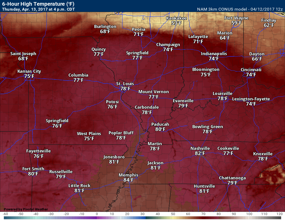
Highs on Thursday will pop several degrees above normal. Most areas will reach the upper 70’s and a few areas will touch 80 degrees! I doubt there will be any complaints about Thursday’s weather. A few clouds (especially during the afternoon hours).
Showers and storms will remain to our west and north on Thursday.
High temperature forecast for Thursday.
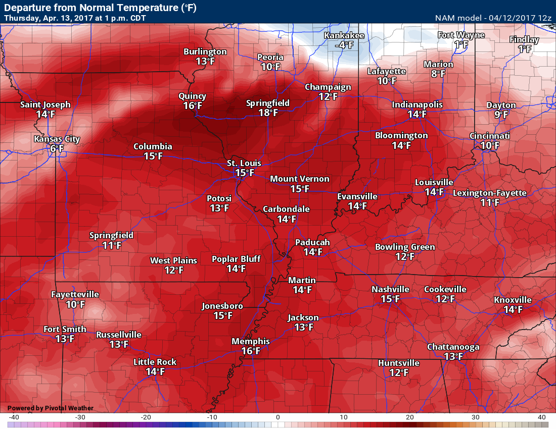
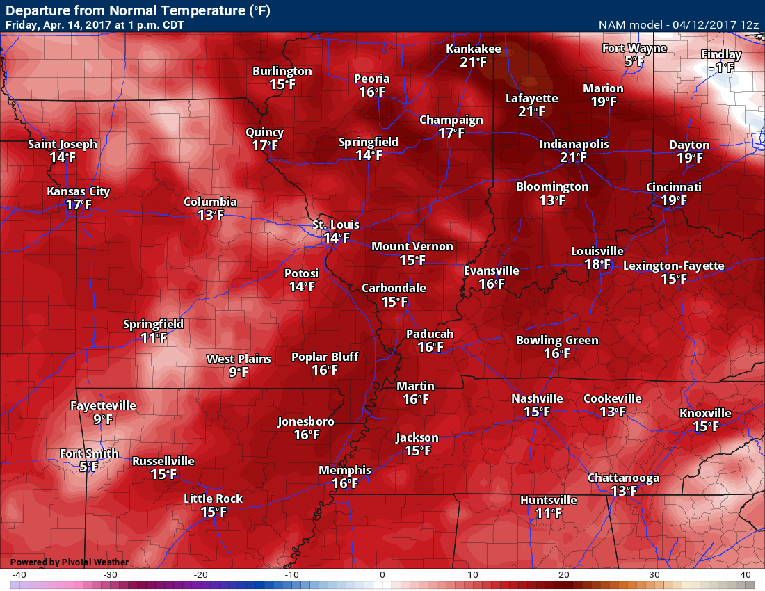
Temperatures on Wednesday will be above normal. Here is the temperature anomaly map.
Normal high temperatures are around 65 degrees.
Thursday night into Friday night:
Moisture will start to increase a bit late Thursday night. Dew points will be on the rebound. I can’t rule out a stray shower or thunderstorm late Thursday night over southeast Missouri and northern parts of southern Illinois, for the most part, it should remain dry. Lows on Thursday night will dip into the 56 t0 62 degree range. Mild.
Scattered showers and storms will be possible Friday and Friday evening. It appears that shower and thunderstorm chances will be capped at around 30% to 40%. The lower numbers for Kentucky and Tennessee. Higher probabilities over Missouri and Illinois. This will not be an all day rain. Scattered showers/storms. Many areas may remain dry on Friday.
Highs on Friday might be tempered a bit by clouds, but it will still be warm. Expect highs in the middle and upper 70’s. If we end up with more sun then some areas will hit 80 degrees.
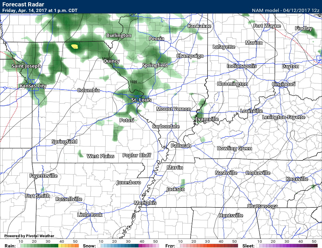
Here is the NAM future-cast radar for Friday. A few pockets of green showing up on this map. As you can see, widespread rain is not anticipated. A few showers and storms.
1 PM future-cast radar. This is what the NAM believes radar will look like on Friday afternoon. Notice how the showers are concentrated over Missouri and Illinois. Some patchy showers or thunderstorms.
Severe weather is not anticipated through Saturday.
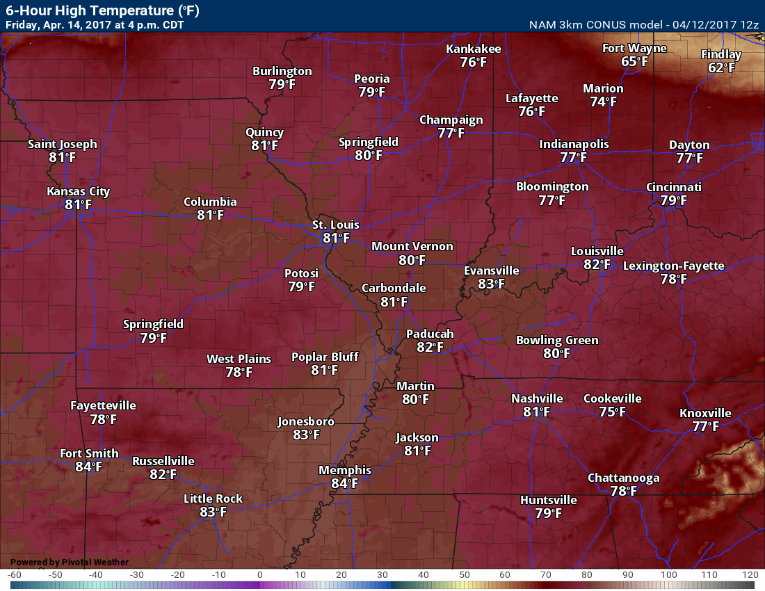
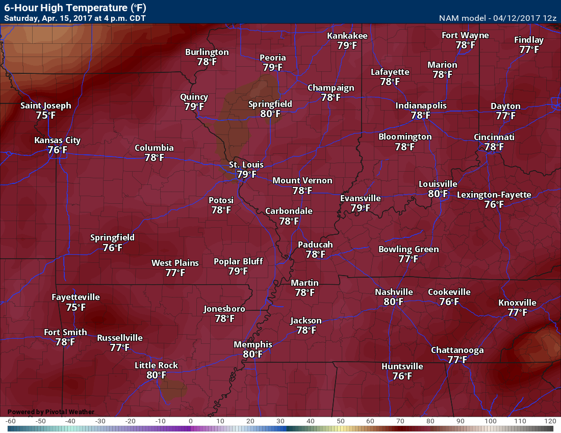
Friday high temperature map
Temperatures are Friday will be highly dependent on cloud cover. More clouds and you can shave a few degrees off this map.
Temperature anomaly forecast for Friday. How many degrees above normal will temperatures be?
Normal high temperatures are around 65 degrees.
Some clouds will linger into Friday night with slight precipitation chances during the early evening hours. Otherwise, some clouds and mild temperatures through the night. Expect lows ranging from 56 to 64 degrees area-wide.
Saturday:
** Pick day of the weekend.
The GREAT news is that Saturday should be a stellar day! We might have some morning fog. Mostly sunny conditions are anticipated through the day (once the fog, if it develops, lifts). It will be warm. Winds might pick up a little bit with gusts to around 20 mph from the south.
Highs on Saturday should reach the upper 70’s to lower 80’s. If you have weekend plans then Saturday will probably be the pick day of the weekend.
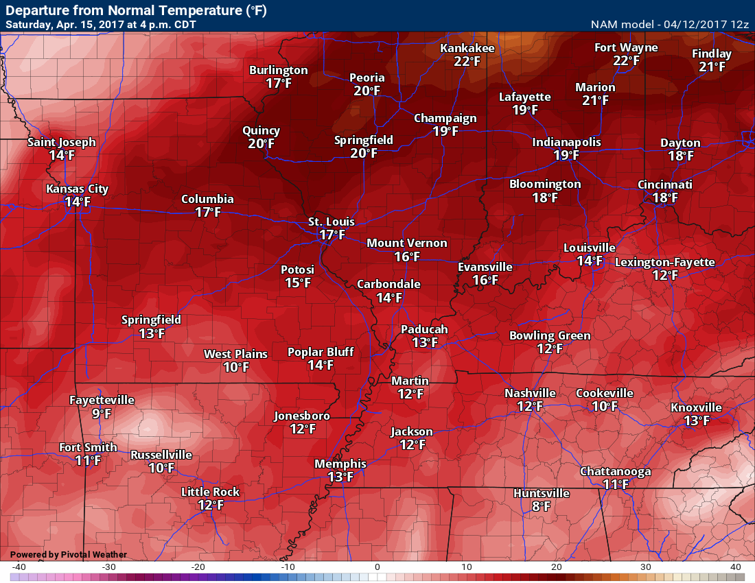
Temperature anomalies for Saturday. How many degrees above or below normal will temperatures be? Definitely above normal!
Normal high temperatures are around 65 degrees.
Saturday night through Monday:
Rain and storm chances increasing.
The bad news is that rain chances will be on the increase from Saturday night into Easter Sunday.
Rain and storms should hold off until after 10 pm Saturday. Saturday evening should be okay.
A frontal boundary will sink towards our region on Saturday night and Sunday morning. This front will slow and possibly stall over our region. This will increase shower and locally heavy thunderstorm chances late Saturday night into Sunday.
There remain some questions on how far south the front will push on Sunday. If it were to push far enough south then it would decrease our rain chances. At this time, plan on showers and thunderstorms. It certainly does look as if chances for precipitation will be high.
Severe weather is currently not anticipated. As always, monitor updates.
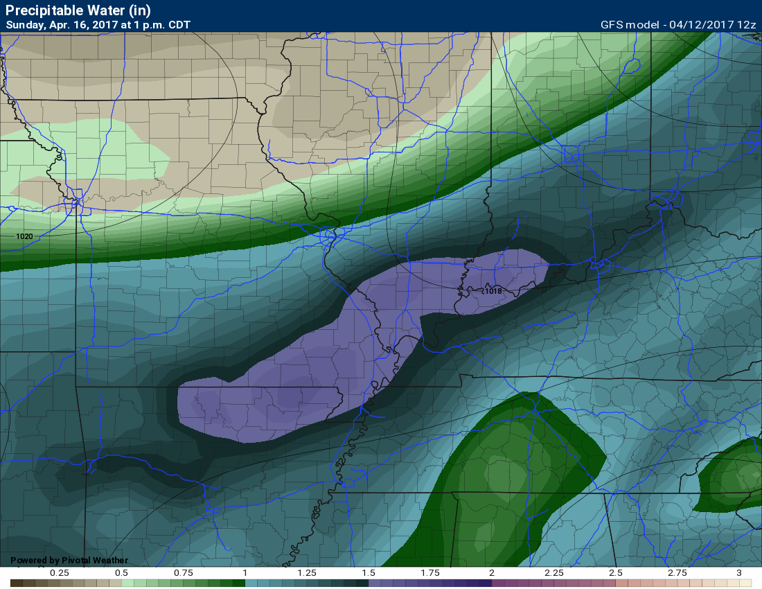
Rainfall totals might be on the heavy side as PWAT values will be on the rise. PWAT is a measure of moisture in the entire atmosphere. The high the PWAT values the greater the risk for locally heavy downpours.
Learn more about PWAT’s here
1 PM Sunday PWAT map. These are some high numbers for April. Locally heavy downpours possible Sunday.
Notice how the numbers drop off north of the front (north of St Louis).
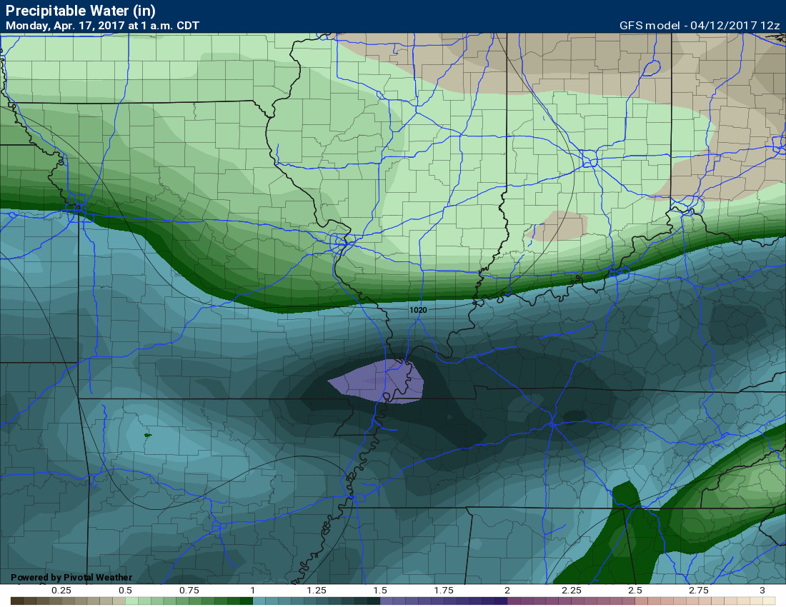
You can see on this next map, for 1 am Monday morning, that the higher numbers are slowly shunted southward. There remains some question as to how far south the front will sag.
If the front hangs up then our rain chances could continue right on through Monday and Tuesday.
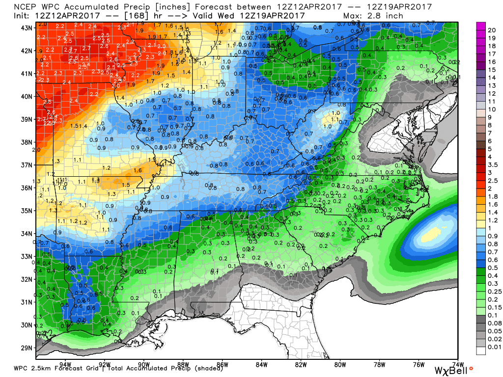
Here is the NOAA/WPC rainfall map
Heavier totals are likely to occur in thunderstorms.
Find me on Twitter

We have regional radars and local city radars – if a radar does not update then try another one. Occasional browsers need their cache cleared. You may also try restarting your browser. That usually fixes the problem. Occasionally we do have a radar go down. That is why I have duplicates. Thus, if one fails then try another one.
During the winter you can track snow and ice by clicking the winterize button on the local city view interactive radars.
If you have any problems then please send me an email beaudodson@usawx.com
Interactive Weather Radar Page. Choose the city nearest your location: Click this link—
National interactive radar: Click this link.
Local interactive city radars include St Louis, Mt Vernon, Evansville, Poplar Bluff, Cape Girardeau, Marion, Paducah, Hopkinsville, Memphis, Nashville, Dyersburg, and all of eastern Kentucky. These are interactive radars. Local city radars – click here
Regional Radar


The official 6-10 day and 8-14 day temperature and precipitation outlook. Check the date stamp at the top of each image (so you understand the time frame).
The forecast maps below are issued by the Weather Prediction Center (NOAA)


The latest 8-14 day temperature and precipitation outlook. Note the dates are at the top of the image. These maps DO NOT tell you how high or low temperatures or precipitation will be. They simply give you the probability as to whether temperatures or precipitation will be above or below normal.


The Beau Dodson Weather APP is ready for Apple and Android users. The purpose of this app is for me to deliver your text messages instantly. ATT and Verizon have not always been reliable when it comes to speed. The app allows instant delivery.
Some of you have asked if you can keep receiving the texts on your phone and the app. The answer to that is, yes. The Android app will automatically allow that to happen. On the Apple app, however, you will need to go into your app and click settings. Make sure the green tab is OFF. Off means you will still receive the texts to your phone and the app. If you have any questions, then email me at beaudodson@usawx.com
The app is for text subscribers.
The direct download, for the Apple app, can be viewed here
https://itunes.apple.com/us/app/id1190136514
If you have not signed up for the texting service then you may do so at www.beaudodsonweather.com

The Android app is also ready.
Remember, the app’s are for www.weathertalk.com subscribers. The app allows your to receive the text messages faster than ATT and Verizon.
Here is the download link for the Android version Click Here

——————————————————–
If you have not signed up for the texts messages, then please do. Link www.beaudodsonweather.com
Your support helps with the following:

and


Who do you trust for your weather information and who holds them accountable?
I have studied weather in our region since the late 1970’s. I have 39 years of experience in observing our regions weather patterns. My degree is in Broadcast Meteorology and a Bachelor’s of Science.
My resume includes:
Member of the American Meteorological Society.
NOAA Weather-Ready Nation Ambassador.
Meteorologist for McCracken County Emergency Management. I served from 2005 through 2015.
Meteorologist for McCracken County Rescue. 2015 through current
I own and operate the Southern Illinois Weather Observatory.
I am the chief meteorologist for Weather Talk LLC. I am the owner of Weather Talk LLC.
I am also a business owner in western Kentucky.
Recipient of the Mark Trail Award, WPSD Six Who Make A Difference Award, Kentucky Colonel, and the Caesar J. Fiamma” Award from the American Red Cross.
In 2005 I helped open the largest American Cross shelter in U.S. history in Houston, Texas. I was deployed to help after Hurricane Katrina and Hurricane Rita. I was a shelter manager of one of the Houston, Texas shelter divisions.
In 2009 I was presented with the Kentucky Office of Highway Safety Award.
Recognized by the Kentucky House of Representatives for my service to the State of Kentucky leading up to several winter storms and severe weather outbreaks.
If you click on the image below you can read the Kentucky House of Representatives Resolution.

I am also President of the Shadow Angel Foundation which serves portions of western Kentucky and southern Illinois.
There is a lot of noise on the internet. A lot of weather maps are posted without explanation. Over time you should learn who to trust for your weather information.
My forecast philosophy is simple and straight forward.
- Communicate in simple terms
- To be as accurate as possible within a reasonable time frame before an event
- Interact with you on Twitter, Facebook, email, texts, and this blog
- Minimize the “hype” that you might see on some television stations or through other weather sources
- Push you towards utilizing wall-to-wall LOCAL TV coverage during severe weather events
Many of the graphics on this page are from www.weatherbell.com
WeatherBell is a great resource for weather model guidance.


You can sign up for my AWARE email by clicking here I typically send out AWARE emails before severe weather, winter storms, or other active weather situations. I do not email watches or warnings. The emails are a basic “heads up” concerning incoming weather conditions