WeatherTalk monthly operating costs can top $2000.00. Your $3 subscription helps pay for those costs. I work for you.
For $3 a month you can receive the following. You may choose to receive these via your WeatherTalk app or regular text messaging.
- Severe weather app/text alerts from my keyboard to your app/cell phone. These are hand typed by Beau. During tornado outbreaks, you will receive numerous app/text messages telling you exactly where the tornado is located.
- Daily forecast app/texts from my computer to your app/cell phone.
- Social media links sent directly to your app/cell phone. When I update the blog, videos, or Facebook you will receive the link.
- AWARE emails. These emails keep you well ahead of the storm. They give you several days of lead time before significant weather events.
- Direct access to Beau via text and email. Your very own personal meteorologist. I work for you!
- Missouri and Ohio Valley centered video updates
- Long-range weather videos
- Week one, two, three and four temperature and precipitation outlooks.
- Monthly outlooks.
- Your subscription also will help support several local charities.
Haven’t you subscribed? Subscribe at www.beaudodsonweather.com

Example of a recent severe weather alert. I issued this well before the official tornado warning. You would have had plenty of time for you and your family to seek shelter.


Your $3 per month also helps support these local charity projects.

I encourage subscribers to use the app vs regular text messaging. We have found text messaging to be delayed during severe weather. The app typically will receive the messages instantly. I recommend people have three to four methods of receiving their severe weather information.
Remember, my app and text alerts are hand typed and not computer generated. You are being given personal attention during significant weather events.

WWW.WEATHERTALK.COM subscribers, here is my day to day schedule for your weather products.


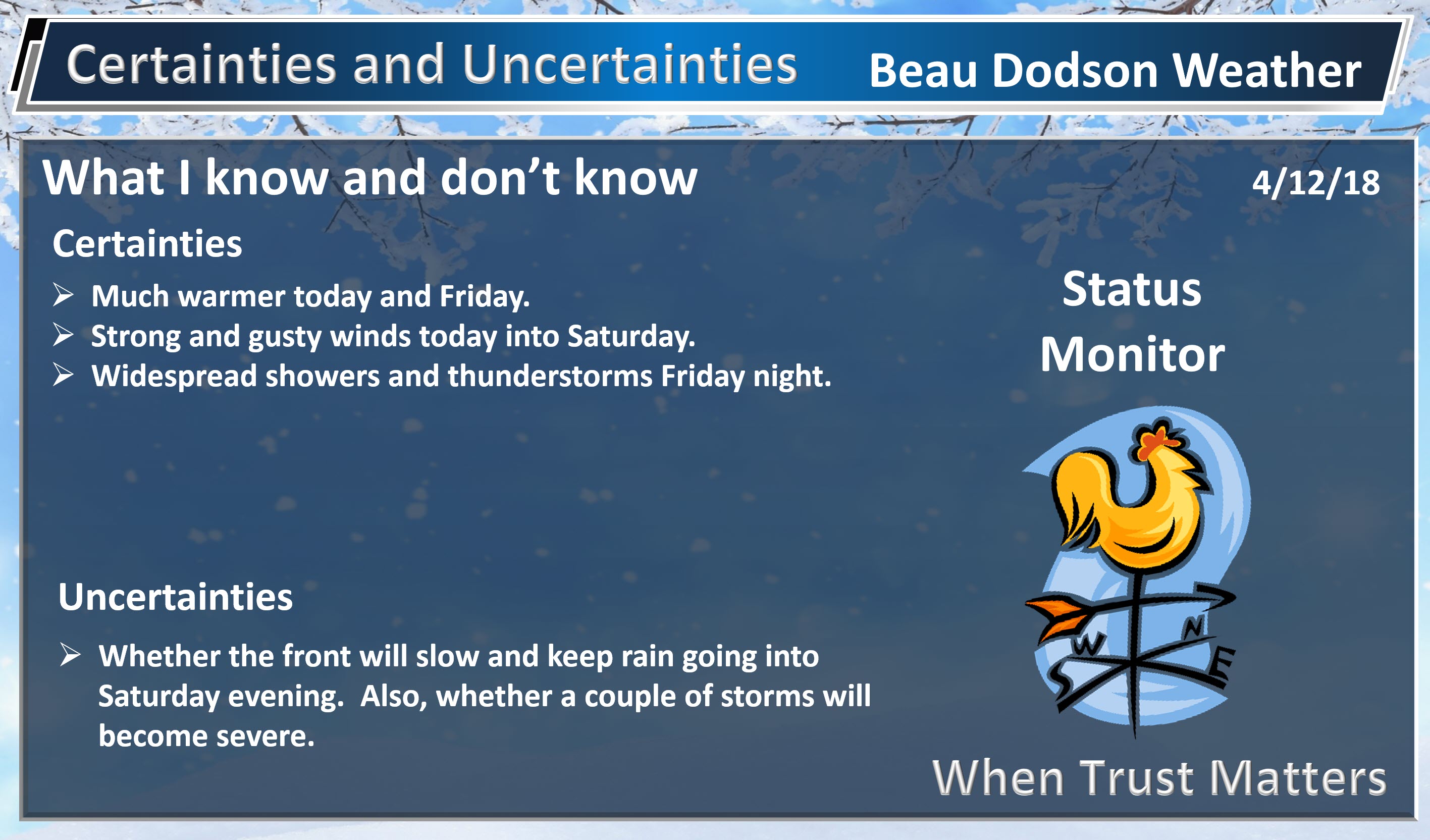
Strong non-thunderstorm winds Thursday into Friday night. Winds may top 40 mph.
April 12, 2018
Thursday Forecast Details
Forecast: Strong winds. Warmer. Spring temperatures. Mostly sunny with a few passing clouds.
Temperatures: MO ~ 75 to 80 IL ~ 75 to 80 KY ~ 75 to 80 TN ~ 75 to 80
What is the chance of precipitation? MO ~ 0% IL ~ 0% KY ~ 0% TN ~ 0%
Coverage of precipitation: None
Winds: South and southwest at 15 to 35 mph with higher gusts
What impacts are anticipated from the weather? Gusty winds.
My confidence in the forecast verifying: High
Is severe weather expected? No
The NWS defines severe weather as 58 mph wind or great, 1″ hail or larger, and/or tornadoes
Should I cancel my outdoor plans? No
Sunrise: 6:24 AM
Thursday Night Forecast Details:
Forecast: Mostly clear early. A few clouds late. Mild. Windy. A fast-moving late-night shower possible across southeast Missouri and southwest Illinois.
Temperatures: MO ~ 58 to 64 IL ~ 56 to 60 KY ~ 58 to 64 TN ~ 58 to 64
What is the chance of precipitation? MO ~ 20% IL ~ 20% KY ~ 10% TN ~ 10%
Coverage of precipitation: None to isolated
Winds: South and southwest at 15 to 30 mph and gusty
What impacts are anticipated from the weather? Gusty winds
My confidence in the forecast verifying: High
Is severe weather expected? No
The NWS defines severe weather as 58 mph wind or great, 1″ hail or larger, and/or tornadoes
Should I cancel my outdoor plans? No
Sunset: 7:26 PM
April 13, 2018
Friday Forecast Details
Forecast: Partly sunny, windy, and warm. Isolated morning and early afternoon showers. There will be an increase in scattered rain showers and thunderstorms late in the day (esp over southeast Missouri and southwest Illinois).
Temperatures: MO ~ 73 to 76 IL ~ 74 to 78 KY ~ 75 to 78 TN ~ 75 to 78
What is the chance of precipitation? MO ~ 30% IL ~ 30% KY ~ 20% TN ~ 20%
Coverage of precipitation: Isolated before 2 PM. Perhaps scattered late in the day over southeast Missouri and southwest Illinois.
Winds: South at 15 to 30 mph and gusty
What impacts are anticipated from the weather? Perhaps wet roadways. Perhaps lightning late in the day across southeast Missouri. Showers early on would be isolated.
My confidence in the forecast verifying: High
Is severe weather expected? Not at this time. Monitor updates.
The NWS defines severe weather as 58 mph wind or great, 1″ hail or larger, and/or tornadoes
Should I cancel my outdoor plans? No, but check updates and radars.
Sunrise: 6:22 AM
The timing of the cold frontal passage Friday night and Saturday will be key to the weekend forecast.
Some of the guidance slows the front considerably Saturday. If this occurs then rain will last longer into the afternoon and evening. This is most likely east of the Mississippi River.
Friday Night Forecast Details:
Forecast: Cloudy. Increasing chances of showers and thunderstorms. Some locally heavy rain possible and gusty winds near storms. Mild temperatures.
Temperatures: MO ~ 56 to 62 IL ~ 56 to 62 KY ~ 58 to 64 TN ~ 58 to 64
What is the chance of precipitation? MO ~ 90% IL ~ 80% KY ~ 70% TN ~ 70%
Coverage of precipitation: Increasing coverage overnight. Becoming widespread.
Winds: South at 10 to 25 mph and gusty.
What impacts are anticipated from the weather? Wet roads and lightning. Monitor the threat of severe weather across southeast Missouri and southwest Illinois.
My confidence in the forecast verifying: High
Is severe weather expected? Severe weather can’t be ruled out. The greater risk will be over southeast Missouri and perhaps southwest Illinois. The main concern would be damaging winds. Monitor updates.
The NWS defines severe weather as 58 mph wind or great, 1″ hail or larger, and/or tornadoes
Should I cancel my outdoor plans? Have a plan B. The later into the evening the greater the rain chances.
Sunset: 7:27 PM
Caution: Saturday’s forecast is lower than normal confidence.
We may have two rounds of rain. One early in the day (before 9 AM) and then a second plume of moisture during the afternoon.
April 14, 2018
Saturday Forecast Details
Forecast: Early morning showers and thunderstorms pushing from west to east. We may then have a lull before a second round of rain impacts portions of the region. Lower than normal confidence in the second round of rain and its placement. The best chance of the afternoon rain will be east of the Mississippi River. Have a plan B in case it rains Saturday.
Temperatures: MO ~ 64 to 68 IL ~ 64 to 68 KY ~ 65 to 70 TN ~ 65 to 70
What is the chance of precipitation? MO ~ 40% IL ~ 50% KY ~ 60% TN ~ 60%
Coverage of precipitation: Numerous before 9 AM. Coverage in the late morning and afternoon will depend on the speed of the front and a possible second wave of precipitation.
Winds: South winds becoming west at 10 to 20 mph and gusty. Winds over southeast Missouri may switch to west/southwest.
What impacts are anticipated from the weather? Wet roadways. Lightning. Monitor the risk of intense thunderstorms across portions of western Kentucky and Tennessee.
My confidence in the forecast verifying: Medium during the morning and then LOW after 9 am.
Is severe weather expected? Some storms could be intense across western Kentucky and Tennessee. Monitor updates.
The NWS defines severe weather as 58 mph wind or great, 1″ hail or larger, and/or tornadoes
Should I cancel my outdoor plans? Have a plan B in the morning and then monitor the afternoon forecast.
Sunrise: 6:21 AM
Saturday Night Forecast Details:
Forecast: Some showers. Greatest coverage will be across Kentucky and Tennessee. Especially the further east you travel. Turning cooler. Gusty winds.
Temperatures: MO ~ 36 to 42 IL ~ 36 to 42 KY ~ 38 to 45 TN ~ 40 to 44
What is the chance of precipitation? MO ~ 30% IL ~ 50% KY ~ 60% TN ~ 60%
Coverage of precipitation: Scattered for Missouri and Illinois. Perhaps numerous over the Pennyrile area of western Kentucky into portions of western Tennessee.
Winds: West and northwest at 6 to 12 mph with gusts to 25 mph
What impacts are anticipated from the weather? Wet roadways. Isolated lightning.
My confidence in the forecast verifying: Medium
Is severe weather expected? No
The NWS defines severe weather as 58 mph wind or great, 1″ hail or larger, and/or tornadoes
Should I cancel my outdoor plans? Have a plan B in case it rains. Monitor radars and updates.
Sunset: 7:28 PM
April 15, 2018
Sunday Forecast Details
Forecast: Intervals of clouds. Cooler. Rain showers possible, especially over southeast Illinois, western Kentucky, and northwest Tennessee. Rain chances decrease as you travel further west.
Temperatures: MO ~ 46 to 52 IL ~ 45 to 50 KY ~ 46 to 52 TN ~ 48 to 52
What is the chance of precipitation? MO ~ 30% IL ~ 30% KY ~ 40% TN ~ 40%
Coverage of precipitation: Scattered
Winds: West at 10 to 20 mph and gusty
What impacts are anticipated from the weather? Perhaps wet roadways.
My confidence in the forecast verifying: Medium
Is severe weather expected? No
The NWS defines severe weather as 58 mph wind or great, 1″ hail or larger, and/or tornadoes
Should I cancel my outdoor plans? No
Sunrise: 6:20 AM
Sunday Night Forecast Details:
Forecast: Intervals of clouds. Colder. Light showers or snow flurries possible. If the clouds clear then frost would be possible.
Temperatures: MO ~ 33 to 36 IL ~ 32 to 35 KY ~ 34 to 38 TN ~ 35 to 40
What is the chance of precipitation? MO ~ 20% IL ~ 20% KY ~ 20% TN ~ 20%
Coverage of precipitation: Isolated
Winds: West and northwest at 6 to 12 mph
What impacts are anticipated from the weather? Wet roadways.
My confidence in the forecast verifying: Medium
Is severe weather expected? No
The NWS defines severe weather as 58 mph wind or great, 1″ hail or larger, and/or tornadoes
Should I cancel my outdoor plans? No
Sunset: 7:29 PM
April 16, 2018
Monday Forecast Details
Forecast: Intervals of clouds and sun. Chilly.
Temperatures: MO ~ 53 to 56 IL ~ 48 to 52 KY ~ 50 to 54 TN ~ 50 to 54
What is the chance of precipitation? MO ~ 10% IL ~ 10% KY ~ 10% TN ~ 10%
Coverage of precipitation: None
Winds: Variable at 5 to 10 mph with gusts to 15 mph
What impacts are anticipated from the weather? None
My confidence in the forecast verifying: Medium
Is severe weather expected? No
The NWS defines severe weather as 58 mph wind or great, 1″ hail or larger, and/or tornadoes
Should I cancel my outdoor plans? No
Sunrise: 6:18 AM
Monday Night Forecast Details:
Forecast: Mostly clear. Frost possible. Chilly.
Temperatures: MO ~ 34 to 38 IL ~ 34 to 38 KY ~ 35 to 38 TN ~ 35 to 40
What is the chance of precipitation? MO ~ 0% IL ~ 0% KY ~ 0% TN ~ 0%
Coverage of precipitation: None
Winds: West at 5 to 10 mph
What impacts are anticipated from the weather? Perhaps frost.
My confidence in the forecast verifying: Medium
Is severe weather expected? No
The NWS defines severe weather as 58 mph wind or great, 1″ hail or larger, and/or tornadoes
Should I cancel my outdoor plans? No
Sunset: 7:30 PM
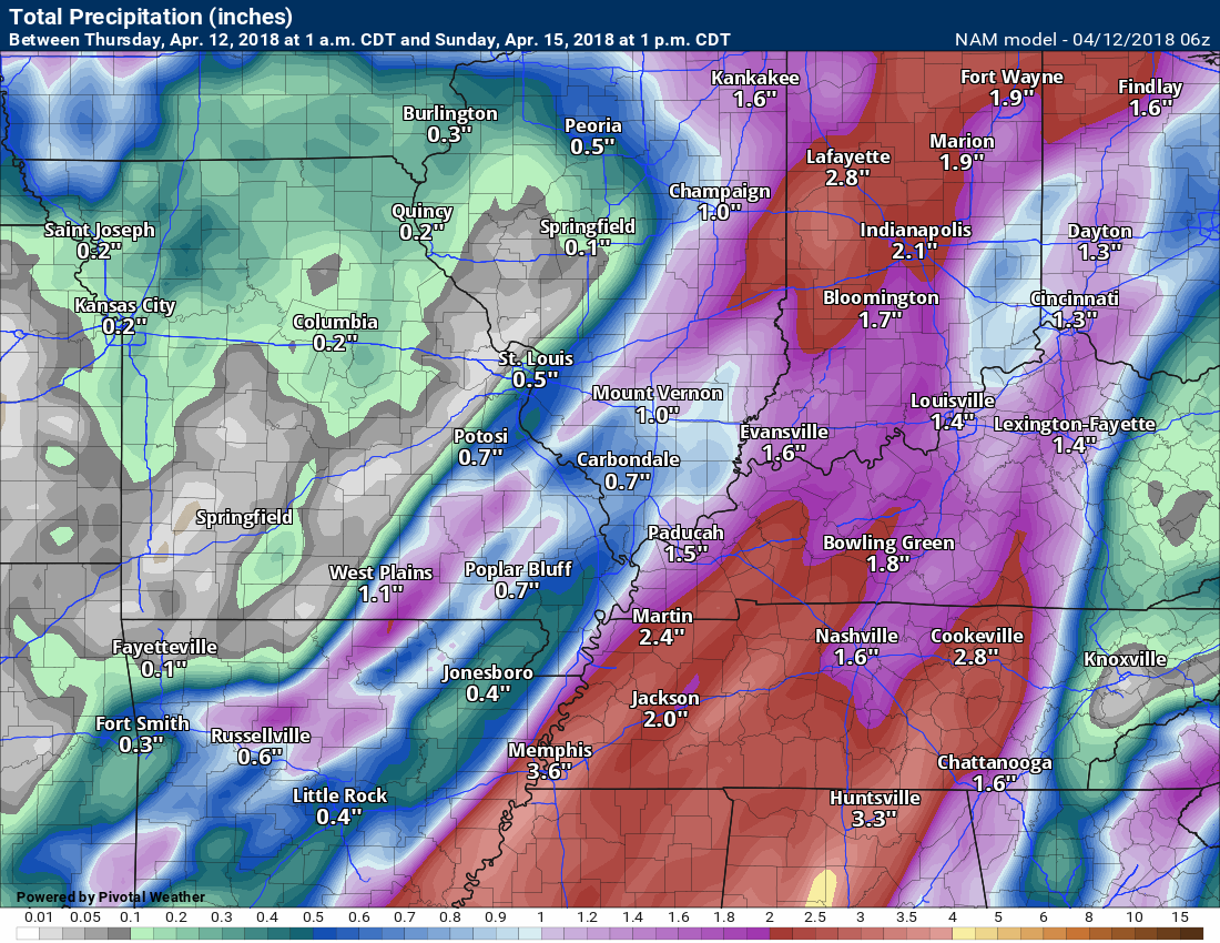
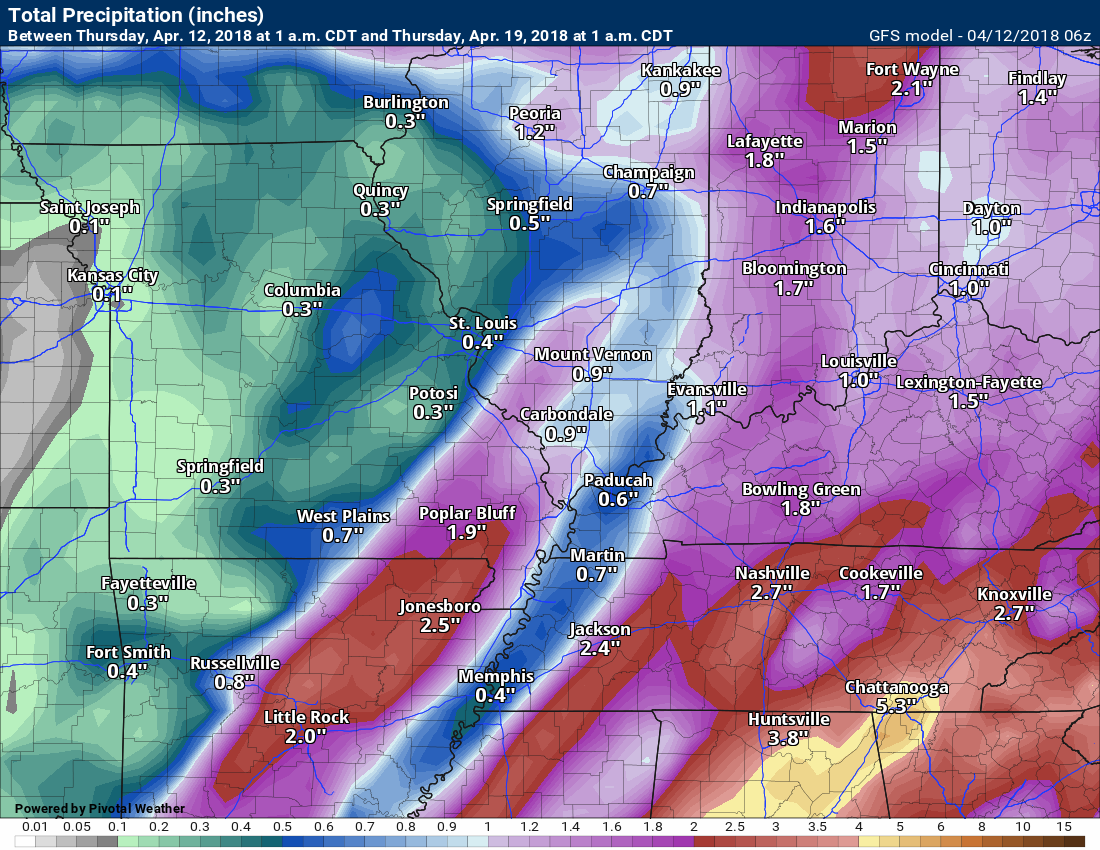
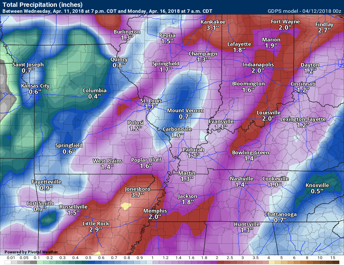
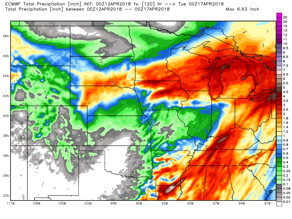
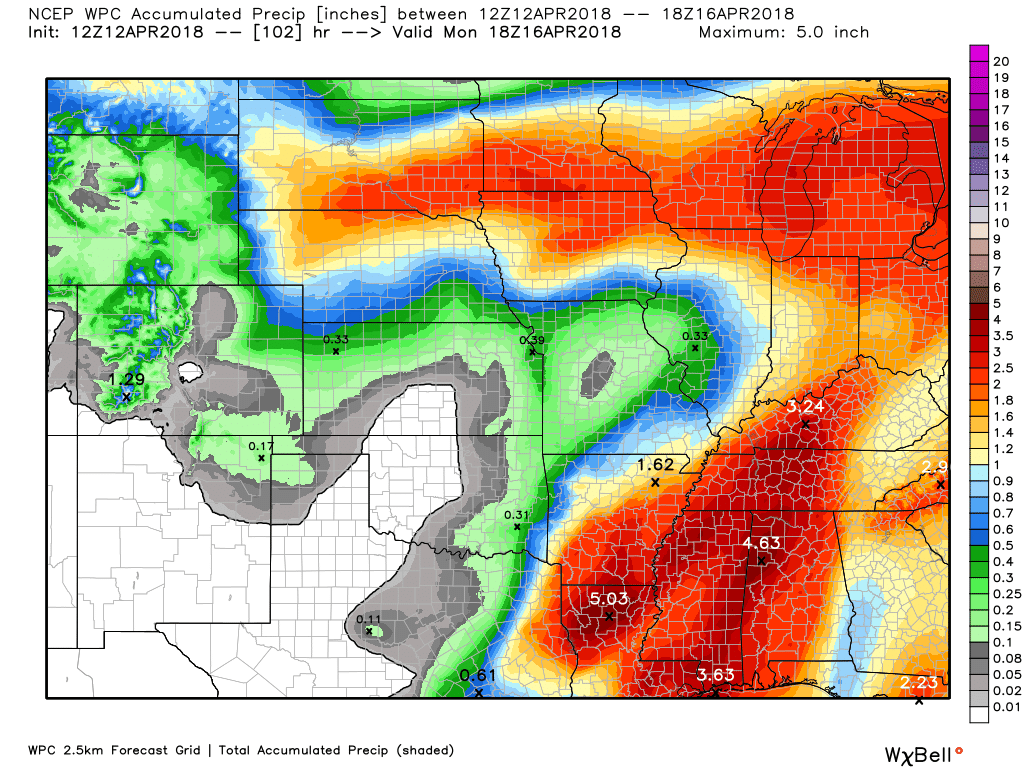
RAIN TOTALS
Let’s take a look at precipitation totals for the Friday through Saturday night event.
Locally heavy rain is possible in a few spots. A few severe storms are also a possibility. Damaging wind would be the primary concern.
The key to the heavy totals will be whether or not the system slows over our region. That is why the heaviest totals are showing up in Kentucky and Tennessee. That is where the front may slow.
It is possible that there will be two rounds of rain. One Friday night into early Saturday morning. A second round Saturday afternoon.
The second round may be centered more on Kentucky and Tennessee and that would be Saturday afternoon.
Either way, plan on rain as we move deeper into Friday night and Saturday morning. Hopefully, the front will push through the region quickly and we can salvage Saturday.
Have a plan B if you have outdoor plans Friday night and Saturday.
These totals won’t be exact, of course. Just take a general idea from the graphics.
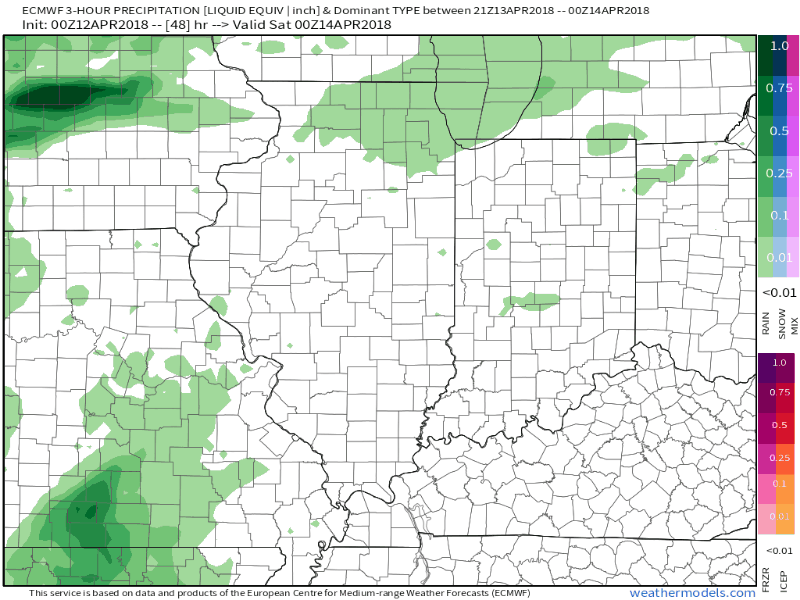
Notice the LARGE differences? That is because some of the models do not slow the system. The EC model is the heaviest. It is also the slowest in pushing the system away from our region.
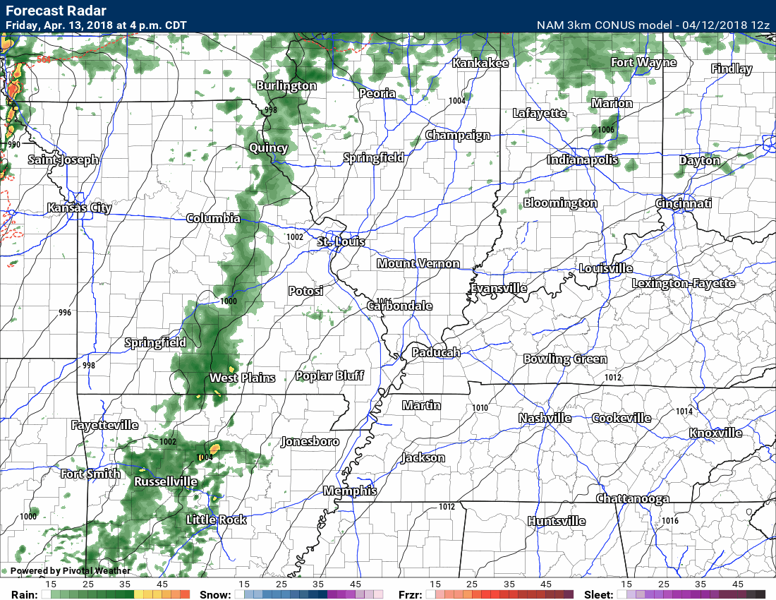
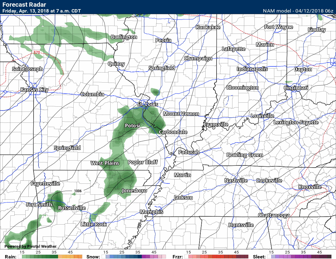
The NAM model guidance
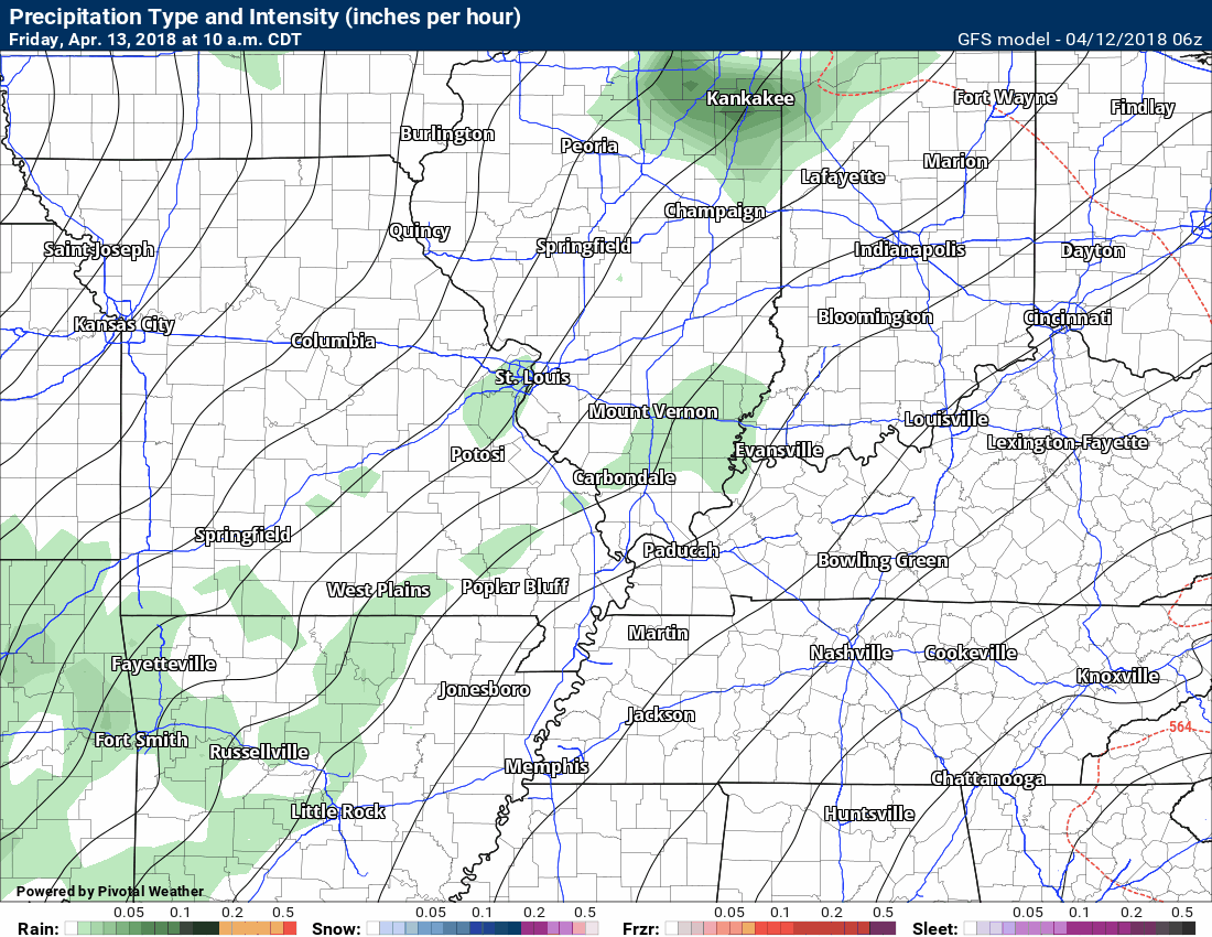
The GFS model guidance
The GEM model guidance
The EC model
NOAA/WPC rain totals forecast

Interactive Radars:
Interactive live weather radar page. Choose the city nearest your location. If one of the cities does not work then try a nearby one. Click here.

Questions? Broken links? Other?
You may email me at beaudodson@usawx.com

The National Weather Service defines a severe thunderstorm as one that produces quarter size hail or larger, 58 mph winds or greater, and/or a tornado.
Thursday and Thursday night: Severe weather is not anticipated.
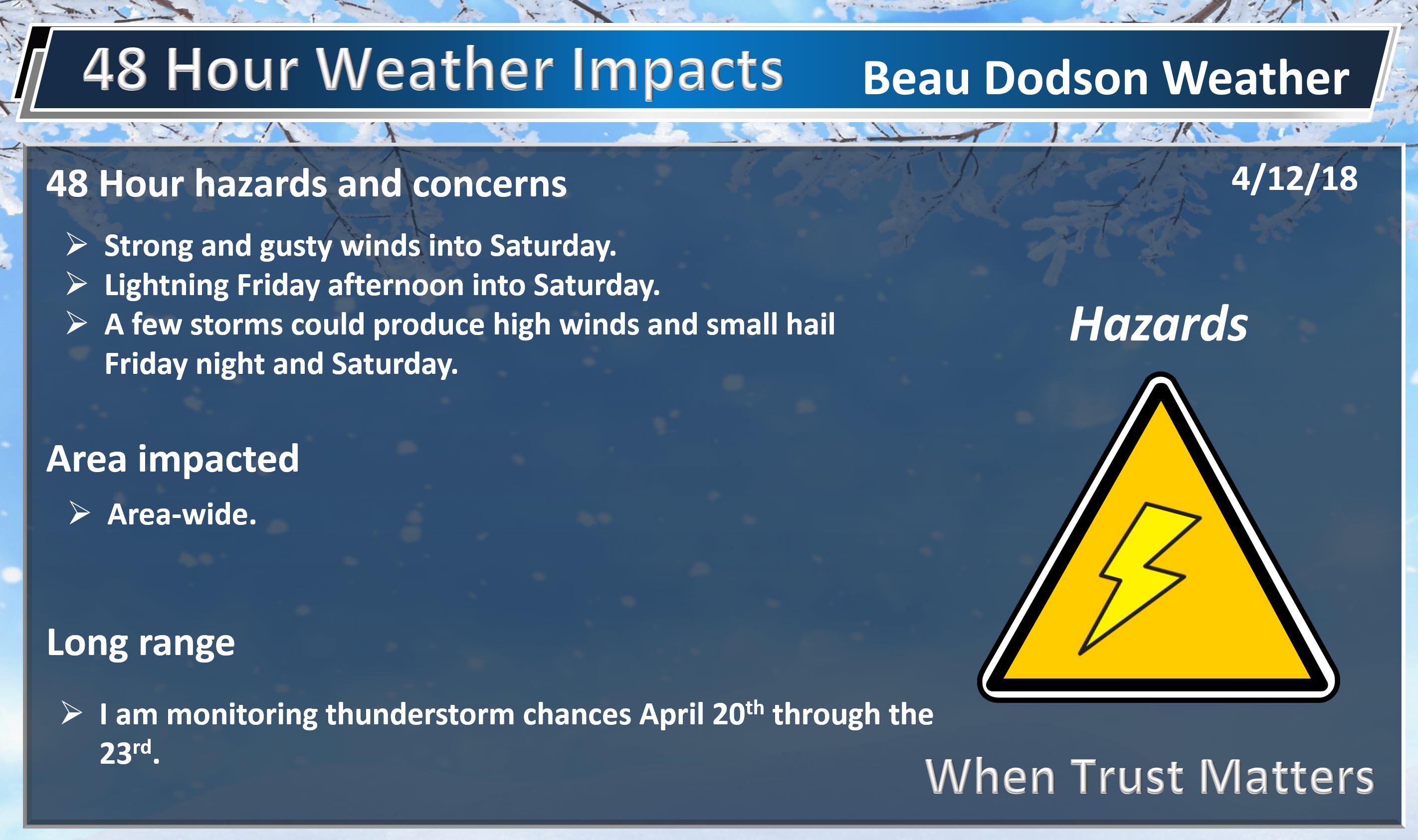
Friday into Saturday: Thunderstorms are likely Friday night. I can’t rule out strong thunderstorms. A few severe thunderstorms are possible across southeast Missouri Friday night. Any shift in the track of the area of low pressure will change the severe weather outlook. Monitor updates.
I am also monitoring southwest Illinois for stronger thunderstorms Friday night.
On Saturday, the risk of intense storms will shift into Kentucky and Tennessee. The main concern would be damaging winds. The Saturday threat is conditional on some heating occurring and instability building.
Sunday into Tuesday: Severe weather is not anticipated.
I am monitoring April 21st through 23rd for thunderstorms.
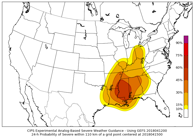
The analog (analog forecasting is forecasting an event based on past similar events) severe weather charts show the best chance of severe weather to our west Friday and Friday night. Southeast Missouri will need to be monitored.
The deeper red is where severe weather is more likely.
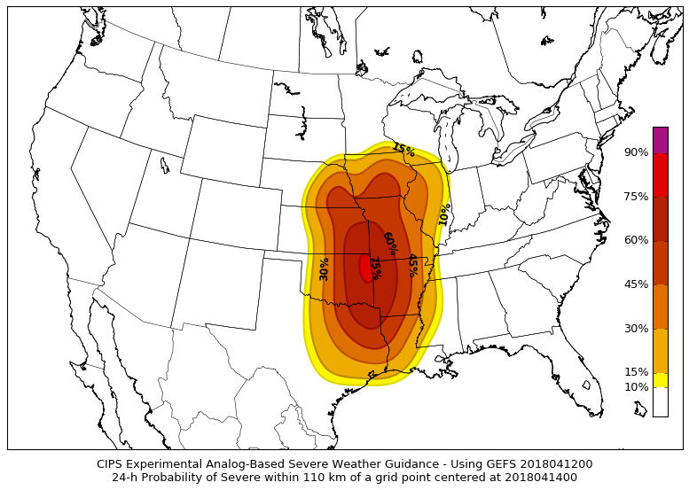
and Saturday
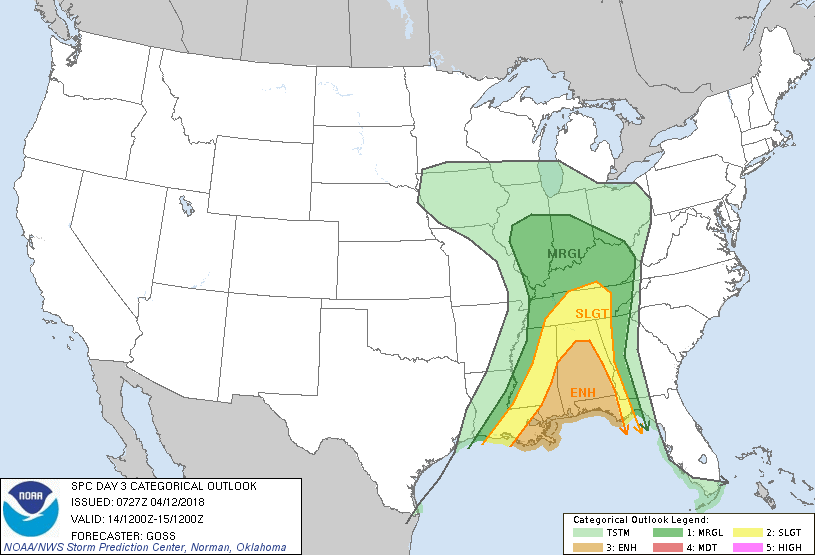
Here is the Storm Prediction Centers severe weather outlook for Friday and Saturday.
Light green is non-severe storms. Dark green is a level one out of five risk. Yellow is a level two out of five risk. Orange is a level three out of five risk. One is the lowest risk.
These outlooks can shift around a bit. Monitor updates.
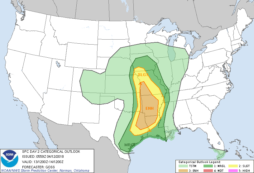
Here is Saturday’s outlook (below).
Our region is in a level one risk. The level two risk attempts to push into Kentucky. Let’s keep an eye on it.
Again, these outlooks can shift around a bit.
![]()
Interactive live weather radar page. Choose the city nearest your location. If one of the cities does not work then try a nearby one. Click here.
National map of weather watches and warnings. Click here.
Storm Prediction Center. Click here.
Weather Prediction Center. Click here.

Live lightning data: Click here.

Interactive GOES R satellite. Track clouds. Click here.

Here are the latest local river stage forecast numbers Click Here.
Here are the latest lake stage forecast numbers for Kentucky Lake and Lake Barkley Click Here.

The spring and preliminary summer outlooks have been posted for subscribers. Scroll down to see the outlook.
Not a subscriber? Learn more at this link.

Weather Headlines
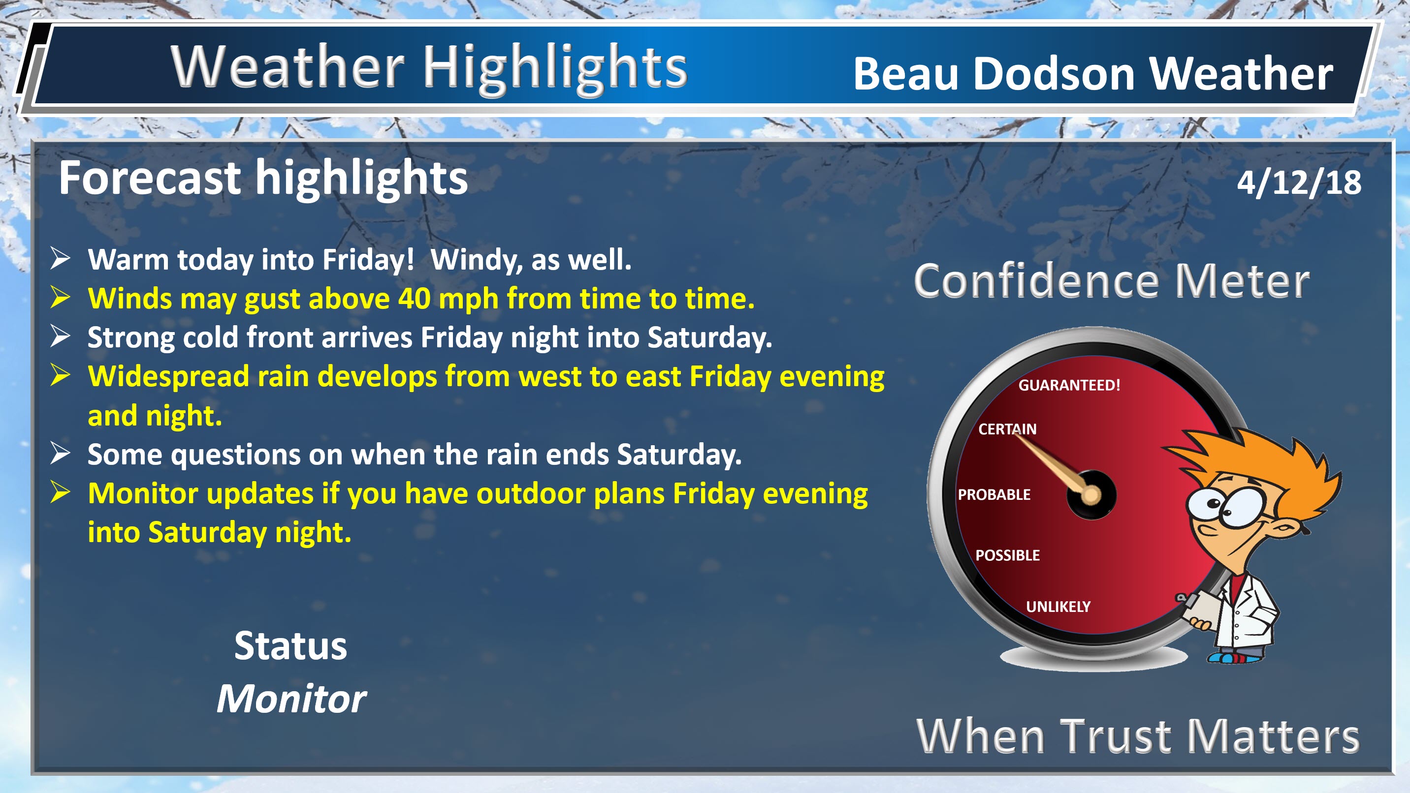
- A warm 48 hours ahead of us. Enjoy it!
- Strong and gusty winds today into Saturday. Winds may top 40 mph from time to time (non-thunderstorm winds)
- Widespread showers and thunderstorms develop from west to east Friday afternoon into early Saturday morning. Locally heavy rain possible.
- A possible second wave of rain later on Saturday.
- Much cooler Sunday and Monday. I can’t rule out frost if clouds clear.
- WeatherBrains has been updated.
The main weather story continues to be the weekend forecast. Not a slam dunk forecast, as is typical in our region.
First, we have warm weather today into Friday afternoon. Temperatures will rise into the 70’s both days. Enjoy it! It won’t last.
Strong and gusty winds will be an issue today into Saturday, as well. You can expect numerous gusts in the 20 to 30 mph range and then higher gusts above 40 mph from time to time. These are non-thunderstorm winds.
The winds are because of a tight pressure gradient. An area of low pressure will strengthen, over the next 24 hours, to our northwest. This will tighten the barometric pressure gradient.
Weekend Rain
Most of you are wondering about rain Friday into Sunday.
Most of Friday will likely remain dry. Some fast-moving showers could occur as early as late tonight into Friday morning. That will likely be the exception. Plan on the bulk of tonight and Friday remaining rain-free.
As we push towards Friday evening you will see showers and thunderstorms increase on the radars to our west and this will spread northeast and east with time.
If you have Friday evening plans monitor radars. The best chance of rainm, during the evening, will be across southeast Missouri and southwest Illinois. The rain will spread east with time.
Widespread showers and thunderstorms will advance through the region as we move through Friday night. Rainfall totals of 0.40″ to 0.80″ will likely occur. Thunderstorms can always produce locally higher amounts.
A few intense thunderstorms will be possible across southeast Missouri and southwest Illinois. Isolated severe weather risk. The main concern would be damaging winds.
Saturday and Saturday night
Don’t cancel your plans, but have a plan B.
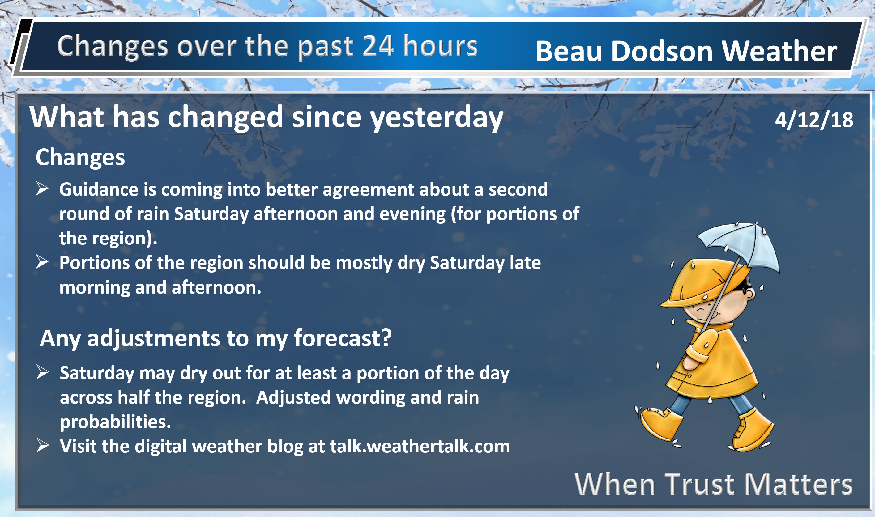
The forecast is increasingly complicated Saturday into Saturday night. Portions of the region may end up mostly dry Saturday.
The cold front will push into the region Saturday morning. Rain showers and thunderstorms will likely occur near the front. As the front pushes eastward we will see a dry slot move into the region. The dry slot should shut the rain down, at least temporarily.
The greatest chance of rain Saturday will be before 9 AM across southeast Missouri and southern Illinois. The rain will then become increasingly scattered or end across those areas.
Rain will linger longer across Kentucky and Tennessee, especially the further east you travel.
The biggest question for Saturday will be a second wave of showers and thunderstorms. The most likely area for this to occur would be southeast Illinois, Kentucky, and Tennessee.
If you have plans Saturday then have a plan B and then plan accordingly. I would not cancel plans, just yet.
Sunday into Sunday night will be cooler with quite a few clouds and a couple of light rain showers.
Temperatures Sunday night and Monday night will be in the 30’s. Frost is again possible, especially if clouds clear.
Let’s look at some future-cast radars.
Here is the NAM 3K model guidance
This is the NAM model guidance
The timestamp is located in the upper left portion of the animation.
GFS guidance
Here is the EC guidance. This is in Zulu time. 12Z is 7 am. 18z is 1 pm. 00Z is 7 pm. 06Z is 1 am.
![]()

Weather Brains is a weekly podcast/video for those who love weather and want more!
Weather Brains episode number 638
Our guest WeatherBrain for this episode is Matt Solum. Matt is the Decision Support Services Program Manager at Western Region Headquarters of the National Weather Service in Salt Lake City, UT. Matt was in the California State Operations Center, basically the state EOC, supporting their full activation as a result of the fires in southern California. Their team was providing forecast information primarily for the California Governor’s Office of Emergency Services (CalOES) and FEMA as it was a joint operation. They also provided weather information to other partners in the room including EPA, CalTrans, DOT, CalEPA, etc. He was deployed to both the October fires and the massive/prolonged December fires. Welcome to WeatherBrains, Matt.
Other discussions in this weekly podcast include topics like:
- Extremes: 101 at Thermal, CA, and 2 at Raco, MI
- Relatively calm weather across US
- Threat for severe wx in Lower Mississippi River Valley on Friday
- Astronomy Outlook with Tony Rice
- and more!
Previous episodes can be viewed by clicking here.

We offer interactive local city live radars and regional radars. If a radar does not update then try another one. If a radar does not appear to be refreshing then hit Ctrl F5. You may also try restarting your browser.
The local city view radars also have clickable warnings.
During the winter months, you can track snow and ice by clicking the winterize button on the local city view interactive radars.
You may email me at beaudodson@usawx.com
Find me on Facebook!

Find me on Twitter!

Did you know that a portion of your monthly subscription helps support local charity projects?
You can learn more about those projects by visiting the Shadow Angel Foundation website and the Beau Dodson News website.

I encourage subscribers to use the app vs regular text messaging. We have found text messaging to be delayed during severe weather. The app typically will receive the messages instantly. I recommend people have three to four methods of receiving their severe weather information.
Remember, my app and text alerts are hand typed and not computer generated. You are being given personal attention during significant weather events.
