![]() .
.

Are you in need of new eye glasses? New contacts? Perhaps you need an eye exam. Then be sure and visit the Eye Care Associates of western Kentucky (the Paducah location). For all of your families eye care needs.
Visit their web-site here. Or, you can also visit their Facebook page.

Best at Enabling Body Shop Profitability since 1996. Located In Paducah Kentucky and Evansville Indiana; serving all customers in between. They provide Customer Service, along with all the tools necessary for body shops to remain educated and competitive. Click the logo above for their main web-site.
You can find McClintock Preferred Finishes on Facebook, as well

Expressway Carwash and Express Lube are a locally owned and operated full-service Carwash and Lube established in 1987.
They have been proudly serving the community for 29 years now at their Park Avenue location and 20 years at their Southside location. They have been lucky enough to partner with Sidecar Deli in 2015, which allows them to provide their customers with not only quality service, but quality food as well.
If you haven’t already, be sure to make Expressway your one-stop shop, with their carwash, lube and deli. For hours of operation and pricing visit www.expresswashlube.com or Expressway Carwash on Facebook.
.
.

Looking for some tasty holiday treats? Fluff Cupcakes has what you and your family need. Located in Benton, Kentucky. They even deliver!

**** VALENTINE’S DAY SPECIAL **** $25 dollar special includes ~ 4 assorted Valentine fluff cupcakes in a fabulous box! 18″ Mylar Happy Valentine Day cupcake balloon tied to the box! Valentine’s Day enclosure card! Free delivery in Marshall County! Free delivery to businesses in Paducah, Murray, and Mayfield! Payment is required at time of order. To place an order you can message Tracy on the fluff cupcake page, email, text, or call. Tracy will invoice thru PayPal, & also accepts credit/debit cards, cash, and/or checks. 270-205-2552 tracyd@dcelectricinc.com
I have used Fluff Cupcakes, during Thanksgiving and Christmas, for the last couple of years. I can tell you that the cupcakes are delicious. Be sure and contact Tracy and place your order. Birthdays, holidays, or just because! Visit them on Facebook at this link – click here
..

I have launched a new weather texting service! Be sure and sign up and fully support all of the weather data you see each day.
Weather Talk is a monthly subscription texting (and more) service. Supporting this helps cover the daily costs (average monthly costs are $700+) or all of the data, my time, and the Shadow Angel Foundation. The cost is $3 a month for one phone, $5 a month for three phones, and $10 a month for seven phones. You can sign up and opt out of the text messages, as well.
For more information visit BeauDodsonWeather.com
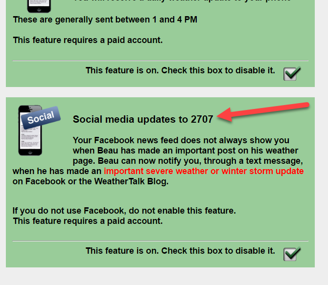
If you would like to receive a text notification, when the winter weather outlooks are updated, then make sure you have opted in to text option three. These are found behind the Personal Notification Settings on the weathertalk.com page.
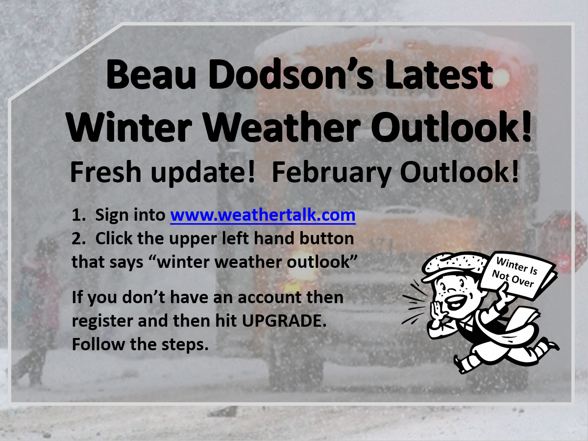
Winter storm forecasts will be posted on the www.weathertalk.com website. Look under the Winter Weather Outlook tab.
Fresh update with new graphics. Tracking multiple precipitation events. Busy busy.

This forecast update covers far southern Illinois, far southeast Missouri, and far western Kentucky. See the coverage map on the right side of the blog
Coming SOON
.
January 17, 2017
Tuesday Night: Patchy fog possible. Clouds. Above normal temperatures. Well above normal temperatures.
What impact is expected? Lower visibility if fog forms.
My confidence in this part of the forecast verifying: Medium. Some adjustments are possible.
Temperatures: Low temperatures from 36 near Mt Vernon to the lower 40’s over extreme southern Illinois, far southeast Missouri, Kentucky, and western Tennessee.
Wind Chill:
Winds: North and northwest at 0 to 5 mph
What is the chance of precipitation? MO ~ <10% IL ~ <10% KY ~ <20% TN ~ <20%
Coverage of precipitation: None anticipated
Will there be a chance for frozen precipitation? No
Is severe weather expected? No
Should I cancel my outdoor plans? No
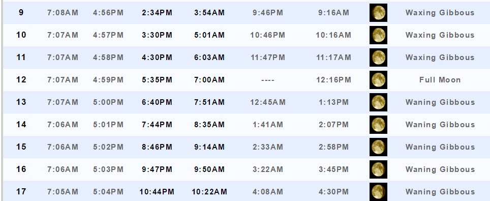
Sunset will be at 5:04 p.m.
Moonrise will be at 10:44 p.m. and moonset will be at 10:22 a.m. Waning Gibbous
.
January 18, 2017
Wednesday: Partly sunny. After 3 pm a 30% for showers over southern Missouri/Missouri Bootheel and northwest Tennessee. Well above normal temperatures.
What impact is expected? Perhaps morning fog. Otherwise, a few showers late in the day moving in from the south. Wet roadways.
My confidence in this part of the forecast verifying: Medium. Some adjustments are possible.
Temperatures: High temperatures in the 48 to 54 degree range.
Wind Chill:
Winds: NE at 5 mph
What is the chance of precipitation? MO ~ 30% IL ~ 20% KY ~ 30% TN ~ 30% (after 3 pm for all four areas)
Coverage of precipitation? Isolated to scattered late in the day over the MO Bootheel and west TN
Will there be a chance for frozen precipitation? No
Is severe weather expected? No
Should I cancel my outdoor plans? No
Sunrise will be at 7:05 a.m. and sunset will be at 5:05 p.m.
UV Index: 1 to 2
Moonrise will be at 11:41 p.m. and moonset will be at 10:54 a.m. Waning Gibbous
Wednesday Night: Cloudy. Showers possible. 40% chance for 12 am and 60% after 12 am. Increasing coverage through the night. Well above normal temperatures.
What impact is expected? Wet roadways.
My confidence in this part of the forecast verifying: Medium. Some adjustments are possible.
Temperatures: Low temperatures from 44 to 48 degree range
Wind Chill:
Winds: East and southeast at 4 to 8 mph
What is the chance of precipitation? MO ~ 40% IL ~ 40% KY ~ 40% TN ~ 40% (increasing to 60% after midnight)
Coverage of precipitation: Increasing coverage through the night
Will there be a chance for frozen precipitation? No
Is severe weather expected? No
Should I cancel my outdoor plans? No
.
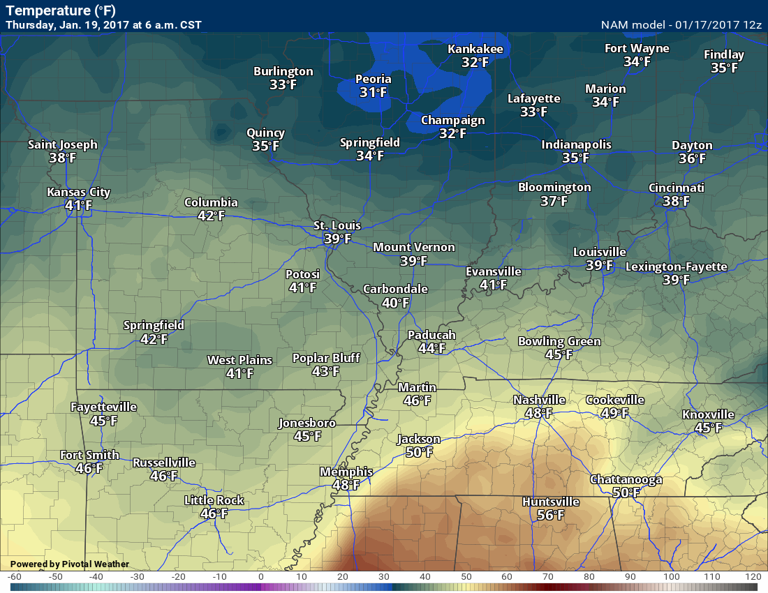
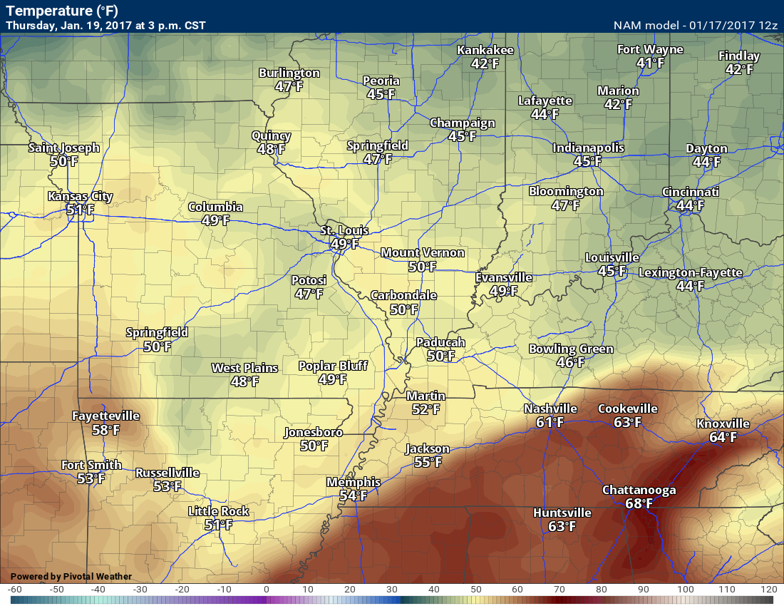
January 19, 2017
Thursday: Cloudy. A good chance for showers and thunderstorms. Moderate rain possible, especially before 12 pm. Well above normal temperatures.
What impact is expected? Lightning. Wet roadways.
My confidence in this part of the forecast verifying: Medium. Some adjustments are possible.
Temperatures: High temperatures in the 54 to 58 degree range.
Wind Chill:
Winds: East and southeast at 6 to 12 mph with gusts to 20 mph.
What is the chance of precipitation? MO ~ 70% IL ~ 70% KY ~ 70% TN ~ 70%
Coverage of precipitation? Widespread
Will there be a chance for frozen precipitation? No
Is severe weather expected? Not at this time. Monitor.
Should I cancel my outdoor plans? Have a plan B.
Sunrise will be at 7:04 a.m. and sunset will be at 5:06 p.m.
UV Index: 0 to 1
Moonrise will be at -:– p.m. and moonset will be at 11:25 a.m. Last Quarter
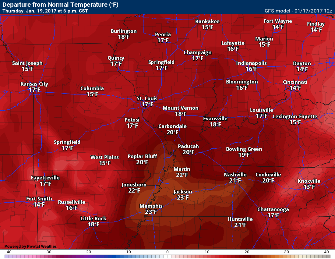
Thursday Night: Showers likely. A thunderstorm possible. Well above normal temperatures.
What impact is expected? Wet roadways. Perhaps lightning.
My confidence in this part of the forecast verifying: Medium. Some adjustments are possible.
Temperatures: Low temperatures from upper 40’s to lower 50’s
Wind Chill:
Winds: South to southwest at 6 to 12 mph with gusts to 20 mph
What is the chance of precipitation? MO ~ 60% IL ~ 60% KY ~ 60% TN ~ 60%
Coverage of precipitation: Perhaps widespread.
Will there be a chance for frozen precipitation? No
Is severe weather expected? Not at this time. Monitor.
Should I cancel my outdoor plans? Have a plan B.
.
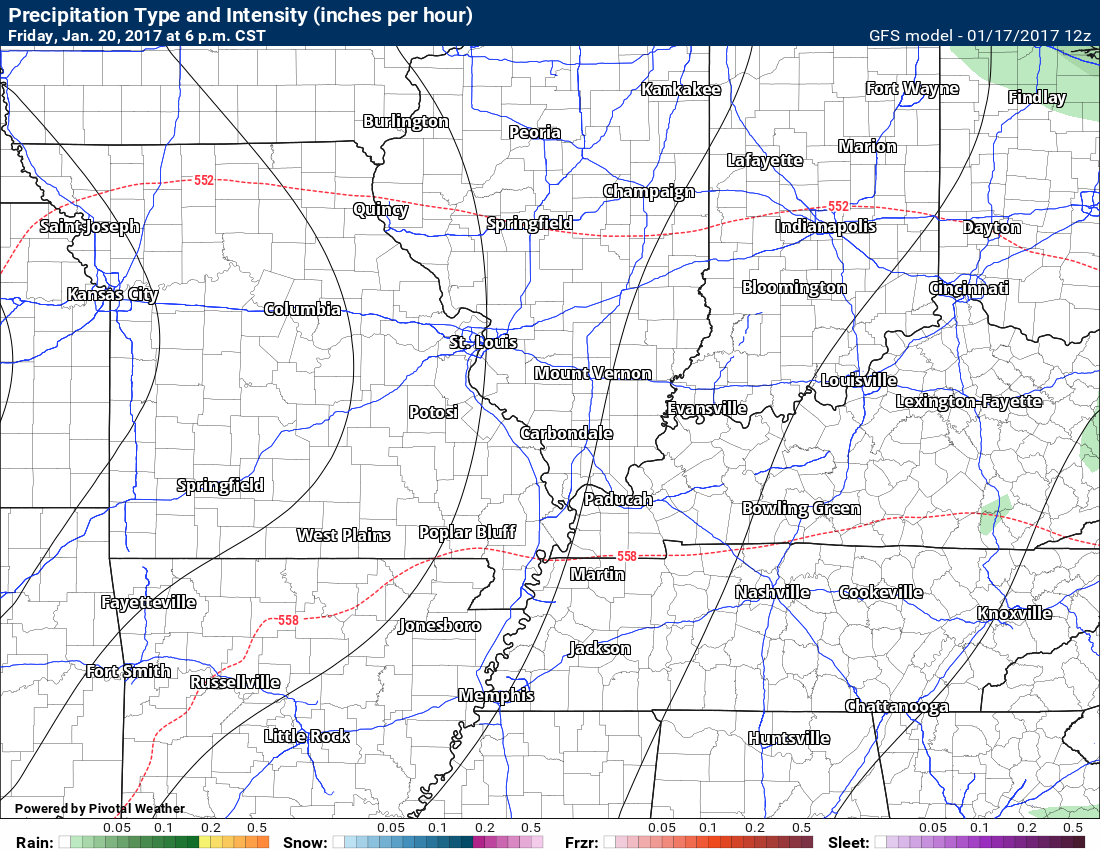
January 20, 2017
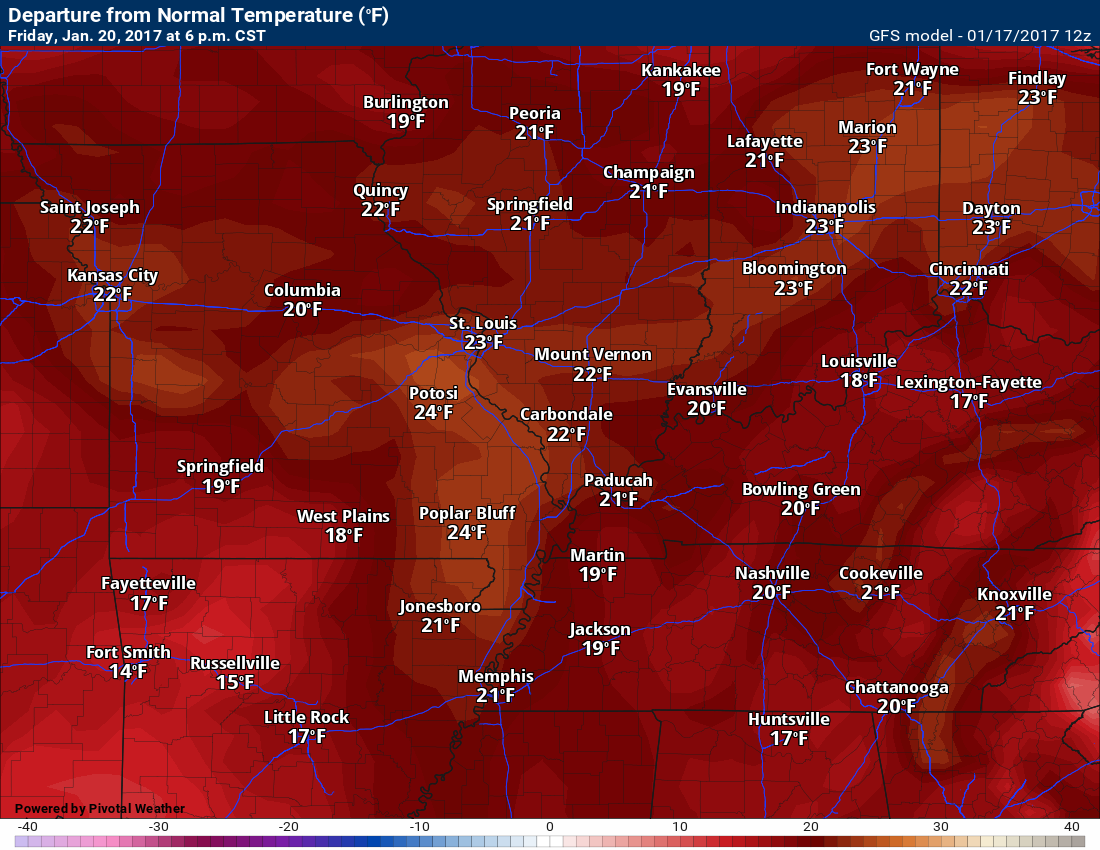
Friday: Partly sunny. Mild for January. Less than a 20% for a shower. Well above normal temperatures.
What impact is expected? Most likely none.
My confidence in this part of the forecast verifying: Medium. Some adjustments are possible.
Temperatures: High temperatures in the 60 to 65 degree range
Wind Chill:
Winds: South and southeast at 6 to 12 mph. Gusts to 20 mph.
What is the chance of precipitation? MO ~ <20% IL ~ <20% KY ~ <20% TN ~ <20%
Coverage of precipitation? Most likely none.
Will there be a chance for frozen precipitation? No
Is severe weather expected? No
Should I cancel my outdoor plans? No
Sunrise will be at 7:04 a.m. and sunset will be at 5:07 p.m.
UV Index: 1 to 2
Moonrise will be at 12:35 a.m. and moonset will be at 11:57 a.m. Waning Crescent
Friday Night: Increasing clouds. A slight chance for a shower late. Well above normal temperatures.
What impact is expected?
My confidence in this part of the forecast verifying: Medium. Some adjustments are possible.
Temperatures: Low temperatures in the lower 50’s
Wind Chill:
Winds:
What is the chance of precipitation? MO ~ 20% IL ~ 20% KY ~ 20% TN ~ 20%
Coverage of precipitation: Perhaps isolated
Will there be a chance for frozen precipitation? No
Is severe weather expected? No
Should I cancel my outdoor plans? No
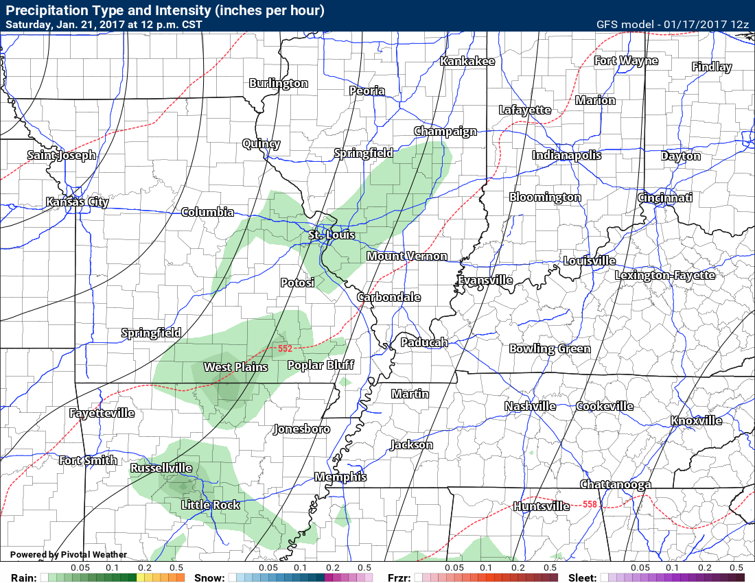
January 21, 2017
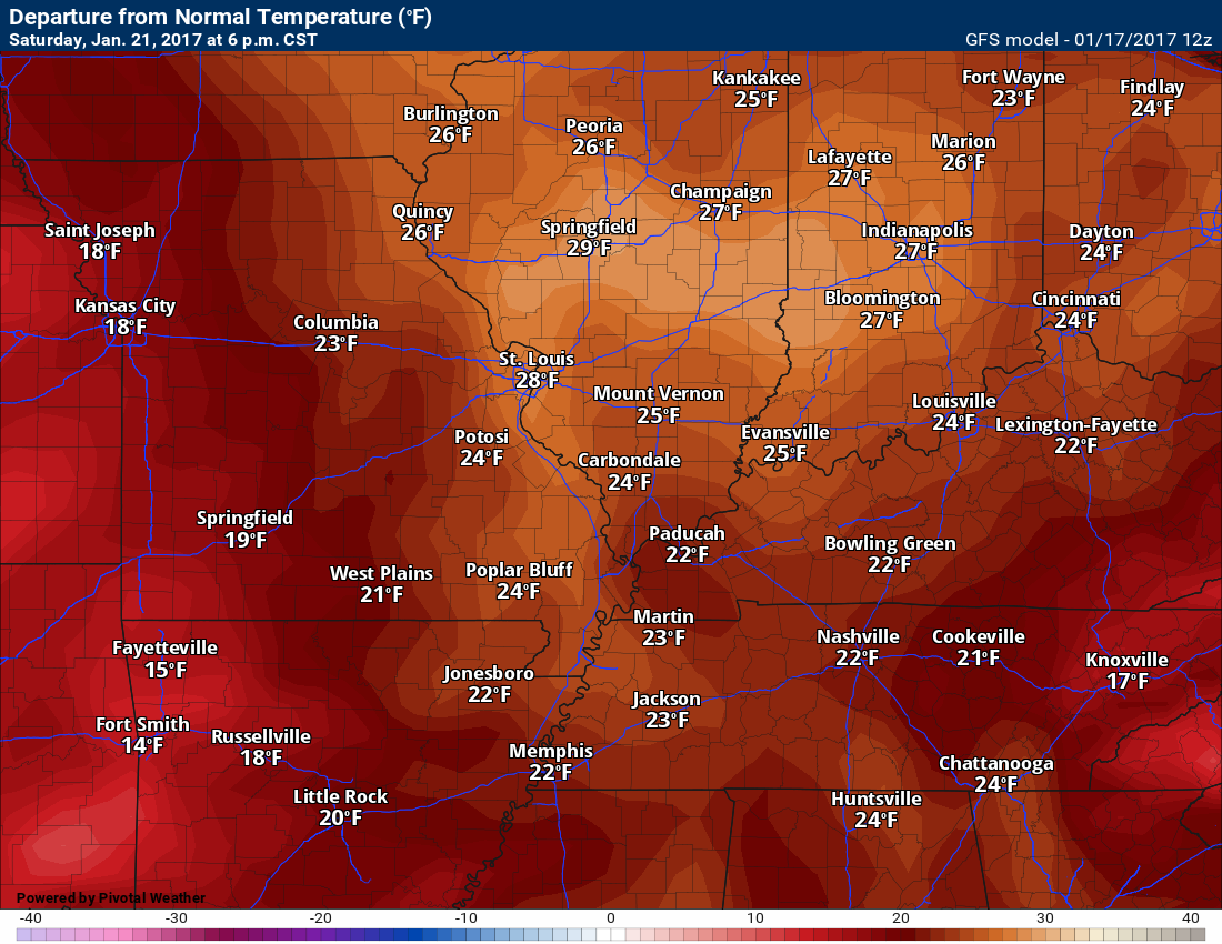
Saturday: Cloudy. A 30% for showers. Mild for January. Well above normal temperatures.
What impact is expected?
My confidence in this part of the forecast verifying: Medium. Some adjustments are possible.
Temperatures: High temperatures in the 64 to 68 degree range
Wind Chill:
Winds: South at 10 to 20 mph
What is the chance of precipitation? MO ~ 30% IL ~ 30% KY ~ 30% TN ~ 30%
Coverage of precipitation? Isolated to perhaps scattered
Will there be a chance for frozen precipitation? No
Is severe weather expected? Not at this time
Should I cancel my outdoor plans? No, but monitor updates.
Sunrise will be at 7:03 a.m. and sunset will be at 5:08 p.m.
UV Index: 0 to 1
Moonrise will be at 1:31 a.m. and moonset will be at 12:31 p.m. Waning Crescent
Saturday Night: Cloudy. A 30% for showers before midnight. A 40% for showers after midnight. Well above normal temperatures.
What impact is expected? Wet roadways.
My confidence in this part of the forecast verifying: Medium. Some adjustments are possible.
Temperatures: Low temperatures in the lower 50’s
Wind Chill:
Winds: Variable at 7 to 14 mph. Gusty
What is the chance of precipitation? MO ~ 40% IL ~ 40% KY ~ 40% TN ~ 40%
Coverage of precipitation: Scattered
Will there be a chance for frozen precipitation? No
Is severe weather expected? Not at this time
Should I cancel my outdoor plans? No, but monitor updates
.
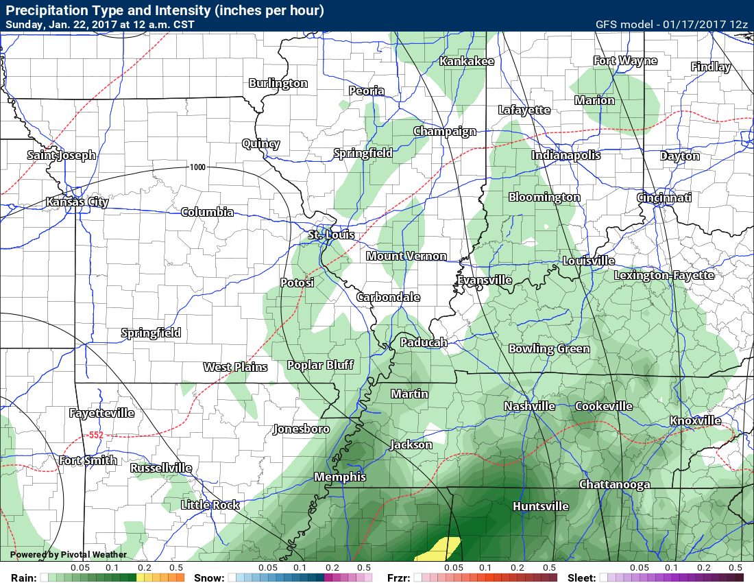
January 22, 2017
Sunday: Cloudy. A chance for showers and thunderstorms. Warm. Well above normal temperatures.
What impact is expected? Lightning. Wet roadways.
My confidence in this part of the forecast verifying: Medium. Some adjustments are possible.
Temperatures: High temperatures in the 58 to 64 degree range
Wind Chill:
Winds: East and southeast at 7 to 14 mph. Gusty.
What is the chance of precipitation? MO ~ 50% IL ~ 50% KY ~ 50% TN ~ 50%
Coverage of precipitation? Scattered to widespread
Will there be a chance for frozen precipitation? No
Is severe weather expected? Monitor updates
Should I cancel my outdoor plans? Have a plan B and monitor updates.
Sunrise will be at 7:03 a.m. and sunset will be at 5:09 p.m.
UV Index: 0
Moonrise will be at 2:25 a.m. and moonset will be at 1:08 p.m. Waning Crescent
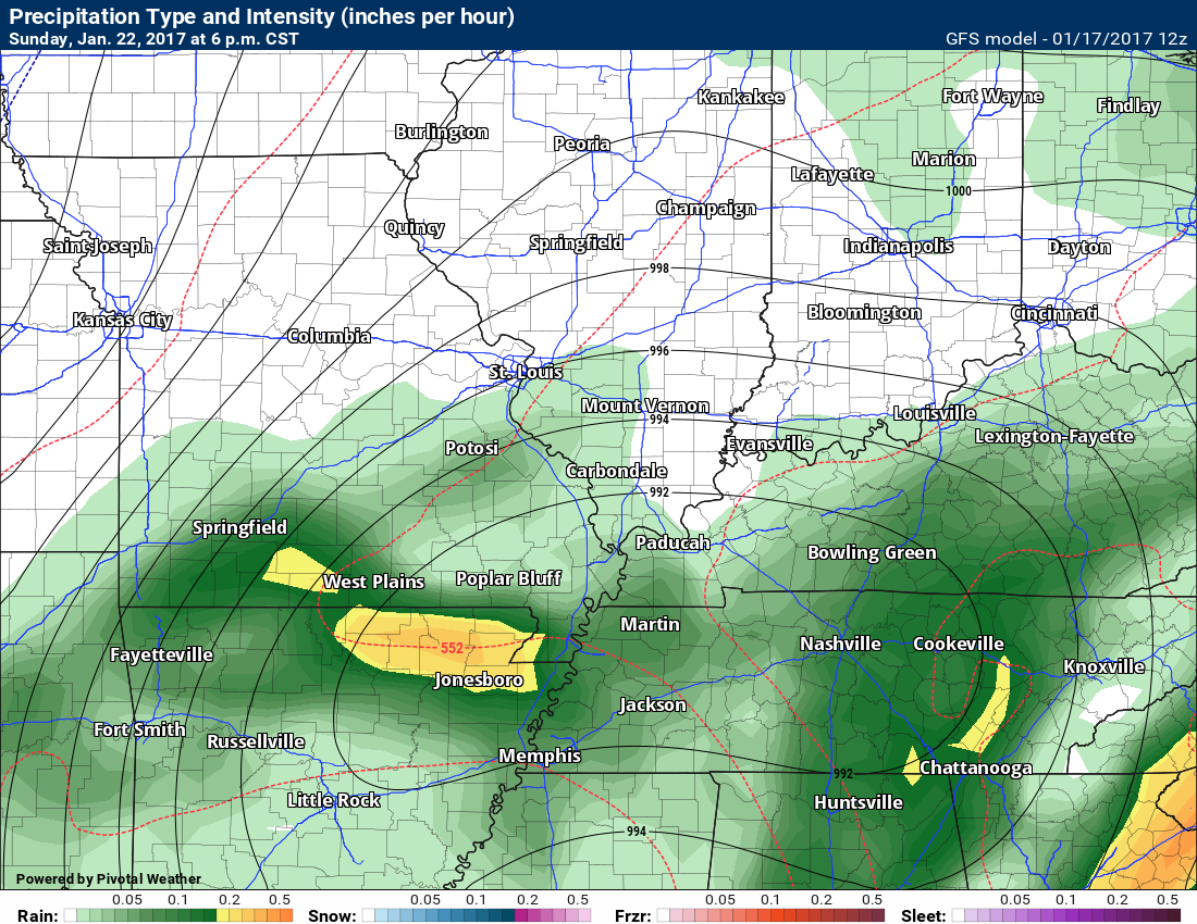
Sunday Night: Cloudy. Showers and thunderstorms likely. Above normal temperatures.
What impact is expected? Wet roadways. Lightning.
My confidence in this part of the forecast verifying: Medium. Some adjustments are possible.
Temperatures: Low temperatures in the upper 40’s to lower 50’s
Wind Chill:
Winds: Variable at 6 to 12 mph with higher gusts possible.
What is the chance of precipitation? MO ~ 60% IL ~ 60% KY ~ 60% TN ~ 60%
Coverage of precipitation: Perhaps widespread.
Will there be a chance for frozen precipitation? No
Is severe weather expected? Monitor updates
Should I cancel my outdoor plans? Have a plan B and monitor updates.
More information on the UV index. Click here

The School Bus Stop Forecast is sponsored by Heath Health and Wellness. Located next to Crowell Pools in Lone Oak, Kentucky.Visit their website here. And. visit Heath Health Foods on Facebook!

Heath Health Foods is a locally owned and operated retail health and wellness store. Since opening in February 2006; the store has continued to grow as a ministry with an expanding inventory which also offers wellness appointments and services along with educational opportunities.

Visit their web-site here. And. visit Heath Health Foods on Facebook!

Don’t forget to check out the Southern Illinois Weather Observatory web-site for weather maps, tower cams, scanner feeds, radars, and much more! Click here

An explanation of what is happening in the atmosphere over the coming day
- Spring weather
- Mild with frequent rain chances.
Tuesday through Thursday
Confidence: HIGH
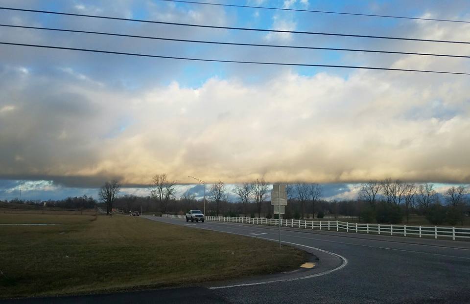
Check out this photograph taken by Tiffany Neal Lanham. Owensboro, Kentucky looking across the Ohio River. Morning fog. Great photograph.
Well above normal temperatures on Tuesday night into Wednesday. Mild for January. I think we are going well past a January thaw.
We will have some fog and clouds to deal with. Fog could be dense in some areas. Keep that in mind.
Rain chances on Tuesday night and Wednesday will be low.
A few showers might move into the Missouri Bootheel and western Tennessee late on Wednesday afternoon or evening. Rain will increase Wednesday night into Thursday.
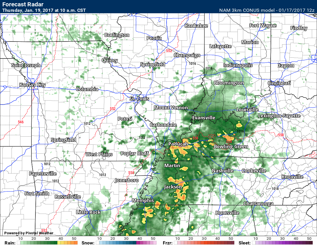
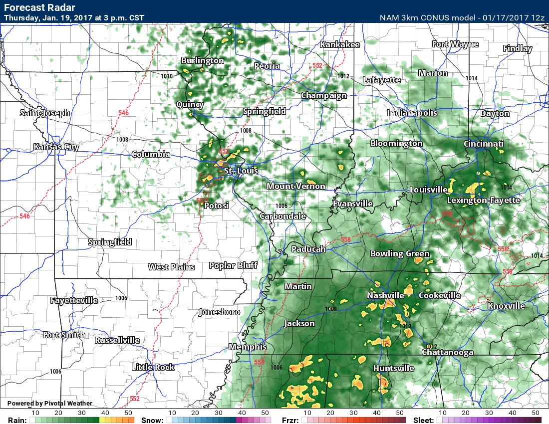
Widespread rain is anticipated late Wednesday night and Thursday. Moderate rain possible. Thunderstorms possible. I will keep an eye on the severe weather risk. Perhaps a greater risk to our south.
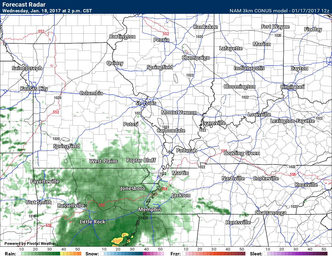
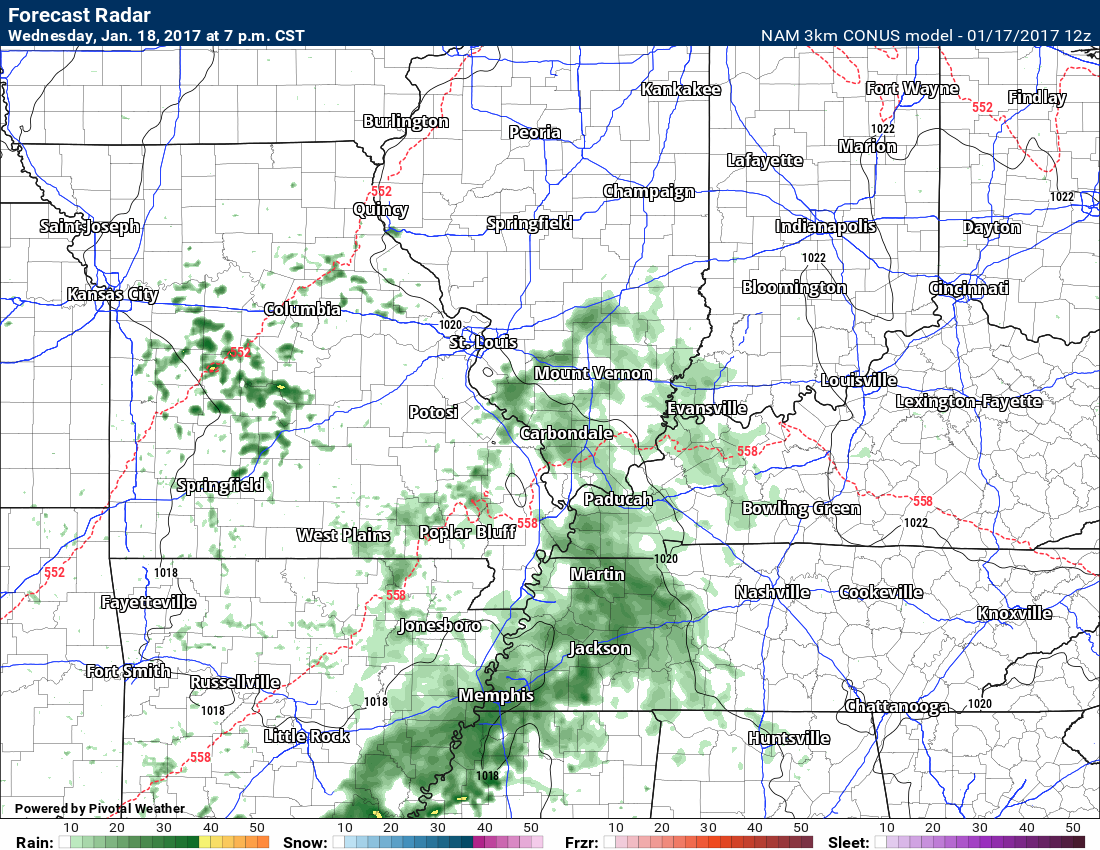
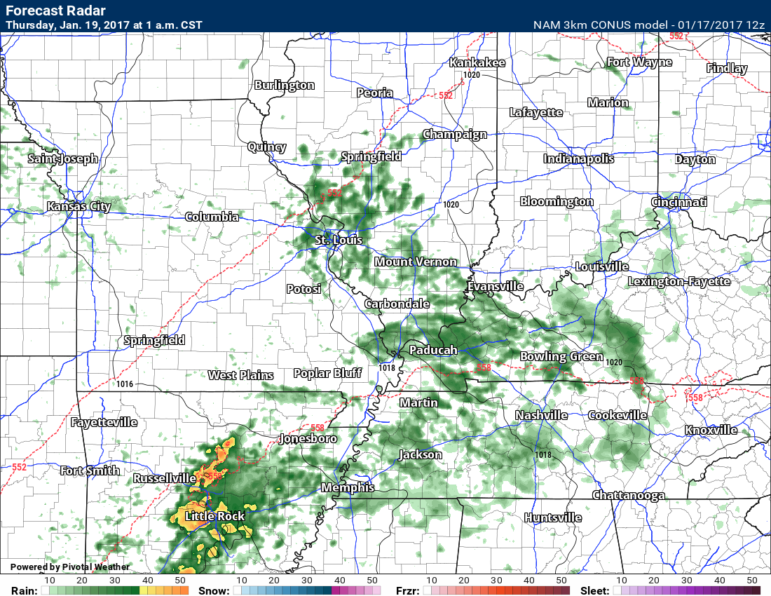
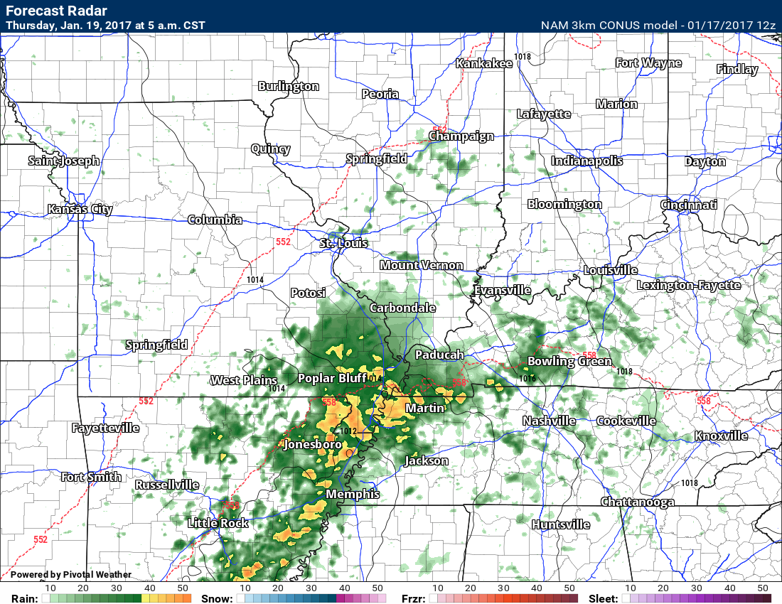
Let’s take a look at the future-cast radar from the high-resolution 3K NAM model guidance.
Notice the rain in Arkansas. It will move north and northeast.
Wednesday 2 PM
Wednesday 7 PM
Thursday 1 AM
Thursday 5 AM
Thursday 10 AM
Thursday 3 PM
Above-normal temperatures for the coming week
Confidence: High
Thursday night through Sunday
Confidence: High
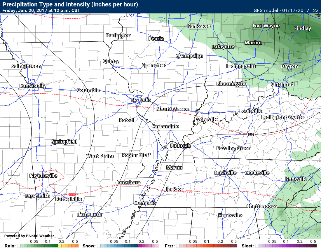
An unsettled weather pattern will remain right on into the weekend. Waves of precipitation will spread across the area. It won’t rain all of the time, but there will be plenty showers and thunderstorms in the region.
Let’s take a look at the longer range GFS guidance. This will give you an idea of what I am talking about.
Friday 12 AM
Friday 12 PM
Friday 6
Saturday 6 AM

Saturday 12 PM
Sunday 12 AM
Sunday 6 PM
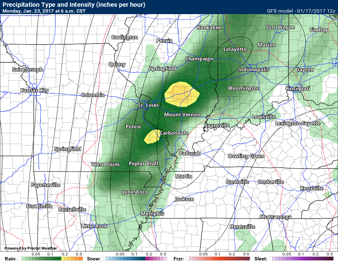
Monday 6 AM
Active pattern. This has been happening since December. Storm systems every few days.
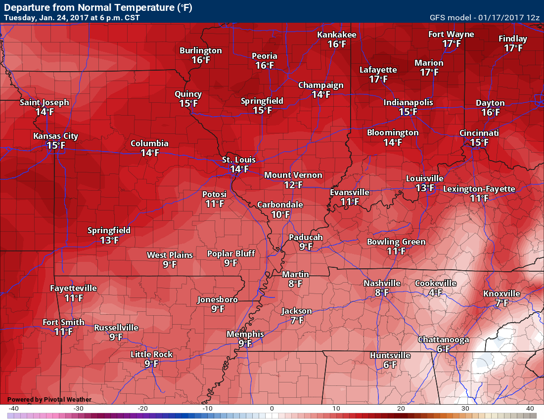
Check out the temperature maps for the coming days. These are the anomalies. How many degrees above or below normal.
Lot of red. ABOVE to WELL above normal temperatures. Normal high temperatures for this time of the year are 40 to 42. Normal low temperatures are 20 to 24.
Thursday
Friday
Saturday
Sunday

Monday

Tuesday
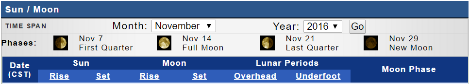
WINTER WEATHER OUTLOOK was updated on Monday, January 16th. The next update will be this coming weekend
Winter weather outlooks will be posted on the www.weathertalk.com website. Look under the Winter Weather Outlook tab. These are updated at least twice each week.
To register and receive the winter weather outlooks, please visit BeauDodsonWeather.com
If you would like to receive a text notification, when the winter weather outlooks are updated, then make sure you have opted in to text option three. The text options are found under the Personal Notification Settings tab on the weathertalk.com website.

Find me on Twitter
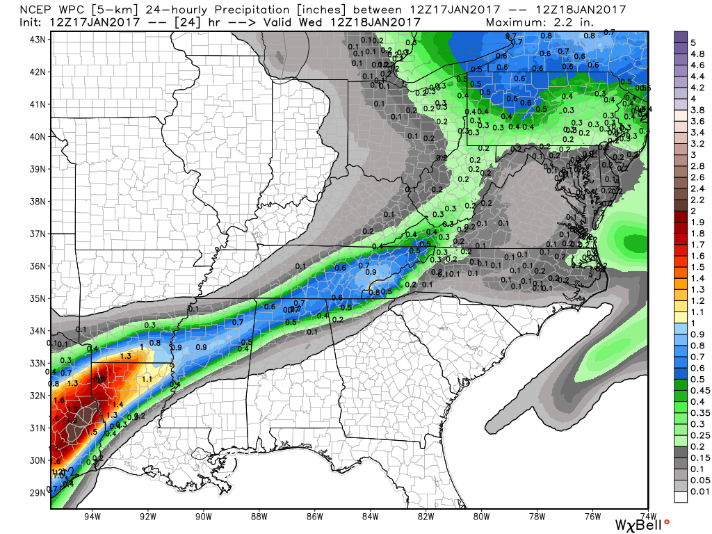
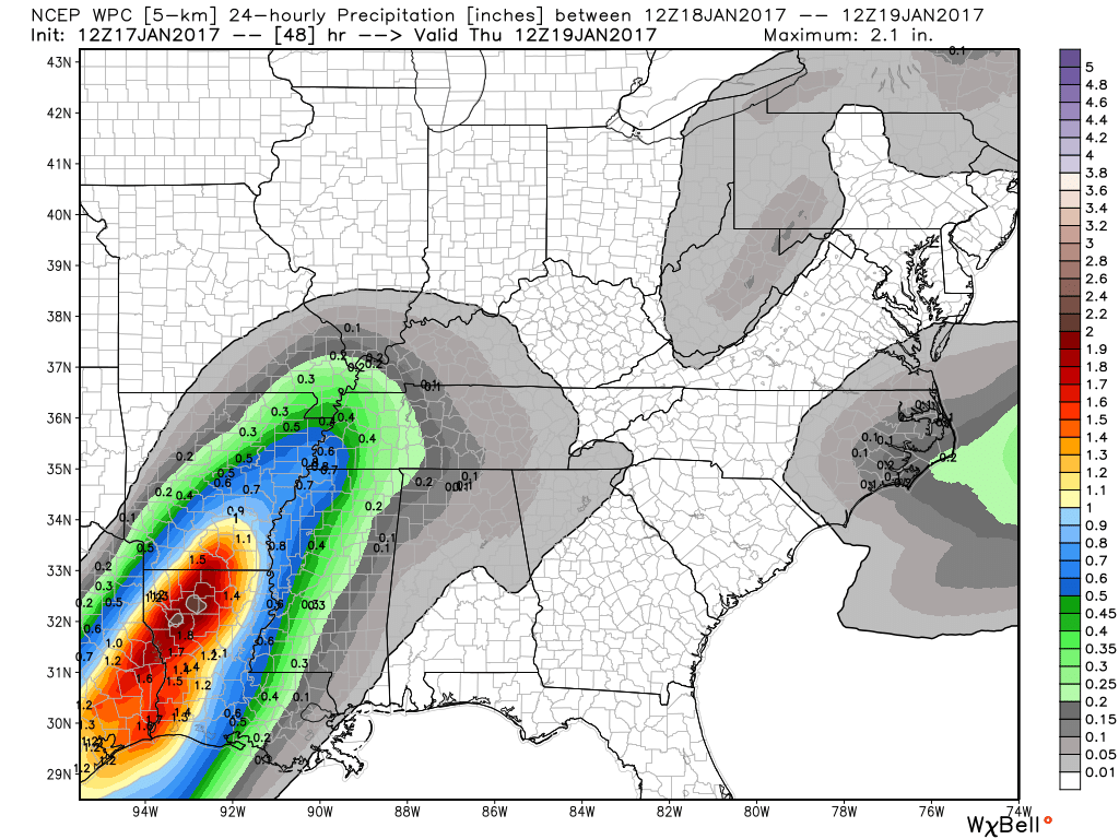
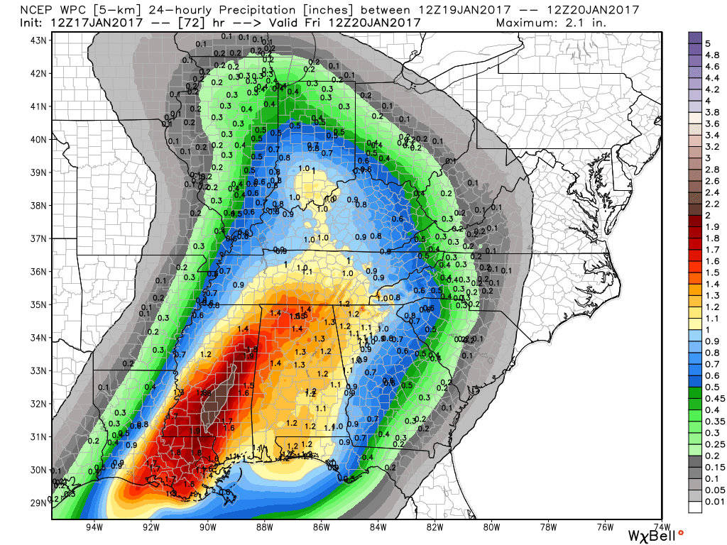
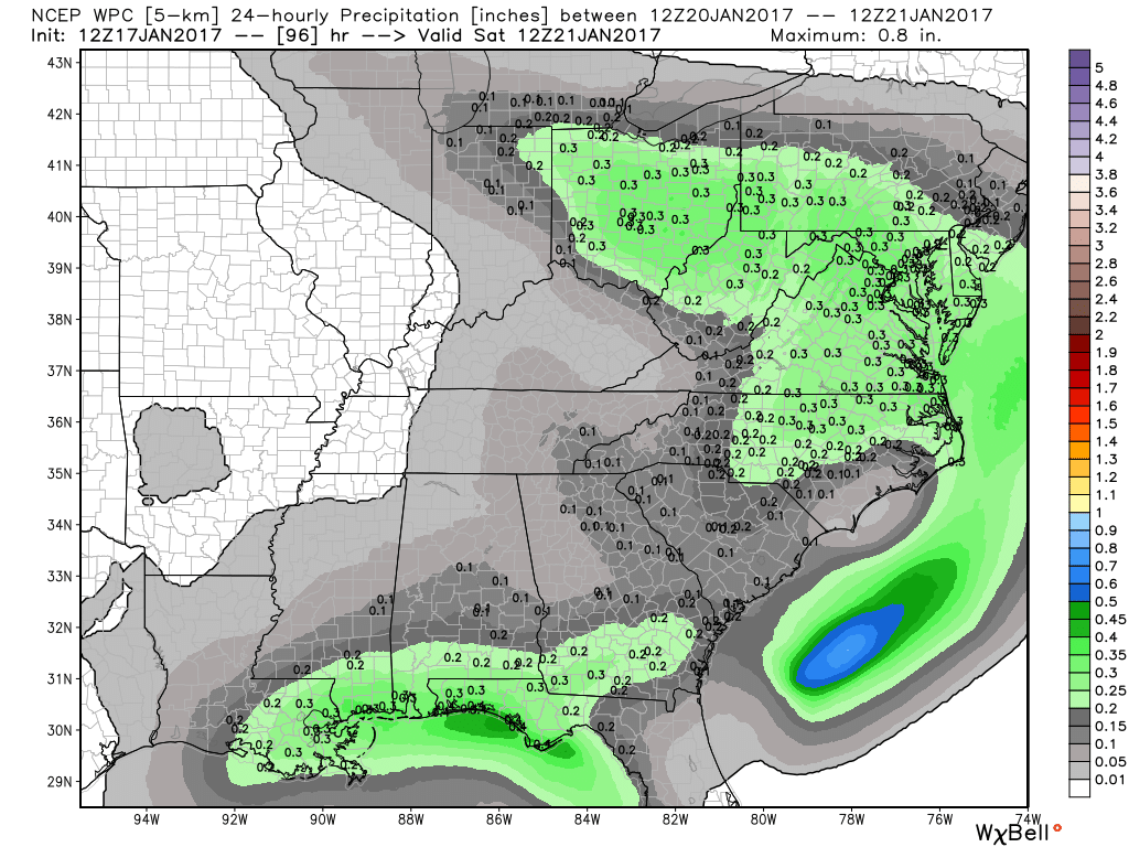
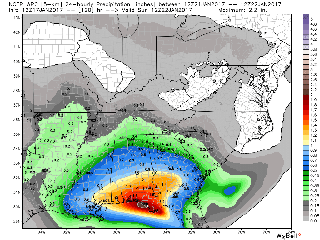
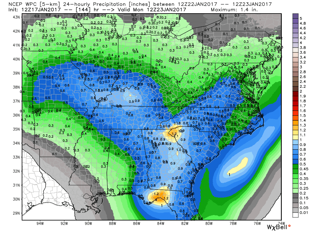
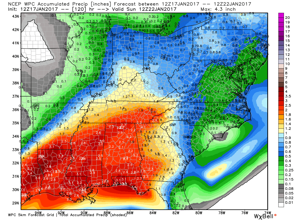
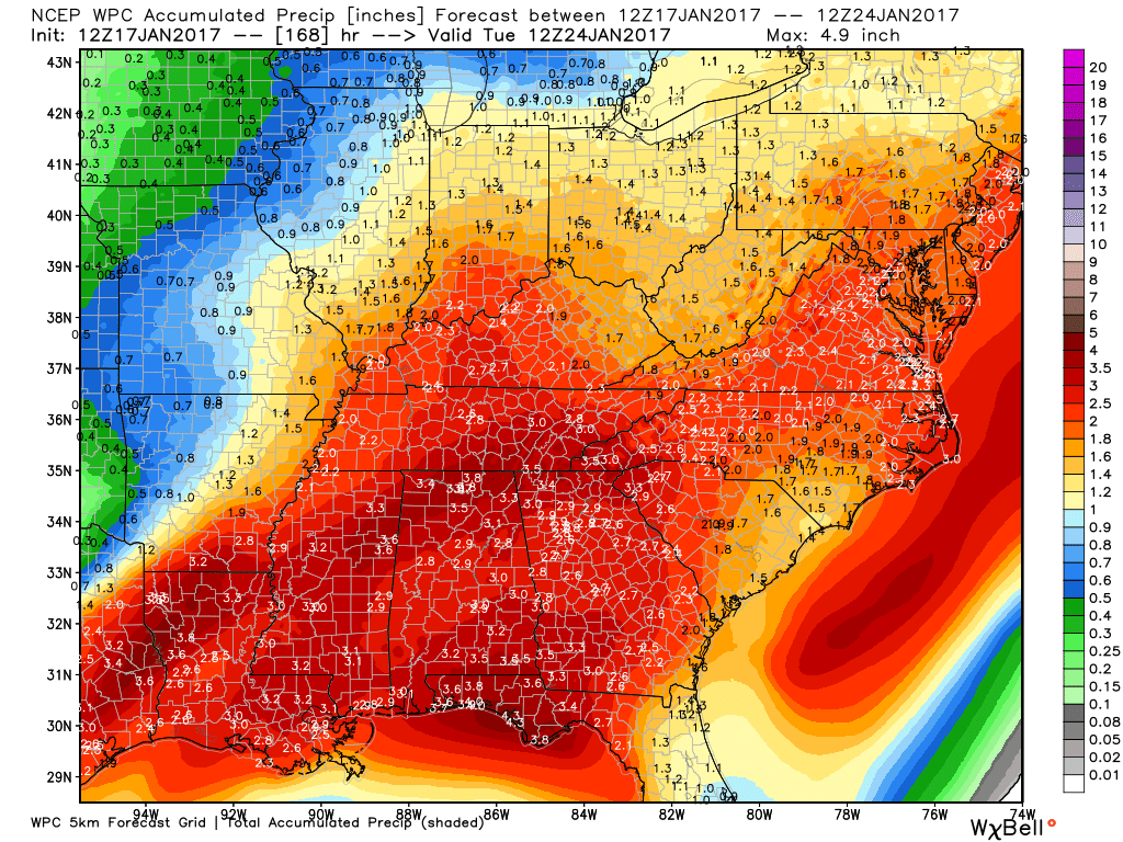
How much rain is expected over the coming days?
Click to enlarge these images from weatherbell.com
Keep in mind, we are dealing with multiple storm systems. Any shift in the path of one or more of the systems would change the rainfall totals.
Locally heavy totals are certainly possible where thunderstorms occur.
This is an active pattern, obviously.
These totals are from 6 am Tuesday through 6 am Wednesday
These totals are from 6 am Wednesday through 6 am Thursday
These totals are from 6 am Thursday through 6 am Friday
These totals are from 6 am Friday through 6 am Saturday
These totals are from 6 am Saturday through 6 am Sunday
These totals are from 6 am Sunday through 6 am Monday
These totals are from 6 am Monday through 6 am Sunday
These totals are from 6 am Sunday through 6 am Monday
If you were to add all of the above graphics together then you would come up with these amounts.
Keep in mind, we are dealing with multiple storm systems. Any shift in the path of one or more of the systems would change the rainfall totals.
Locally heavy totals are certainly possible where thunderstorms occur.
This is an active pattern, obviously.
High and Low-Temperature Outlook
Wednesday morning low temperatures
Wednesday afternoon high temperatures

Thursday morning low temperatures
Thursday afternoon high temperatures

Severe thunderstorm outlook.
Remember that a severe thunderstorm is defined as a thunderstorm that produces 58 mph winds or higher, quarter size hail or larger, and/or a tornado.
Tuesday night through Wednesday night: Severe weather is currently not anticipated.
Thursday through Sunday night: Multiple storm systems will bring periodic showers and thunderstorms. Some of the storms could be strong. Let’s keep an eye on this pattern. Well above normal temperatures. Quite a bit of moisture to work with. Certainly lightning will be possible. Monitor updates.

We have regional radars and local city radars – if a radar does not seem to be updating then try another one. Occasional browsers need their cache cleared. You may also try restarting your browser. That usually fixes the problem. Occasionally we do have a radar go down. That is why I have duplicates. Thus, if one fails then try another one.
If you have any problems then please send me an email beaudodson@usawx.com
WEATHER RADAR PAGE – Click here —
We also have a new national interactive radar – you can view that radar by clicking here.
Local interactive city radars include St Louis, Mt Vernon, Evansville, Poplar Bluff, Cape Girardeau, Marion, Paducah, Hopkinsville, Memphis, Nashville, Dyersburg, and all of eastern Kentucky – these are interactive radars. Local city radars – click here
Regional Radar


.
No major changes in this update. Hot weather in the charts.
.

.
Main concern continues to be hot temperatures and high heat index values. Use care, as always.
Scattered thunderstorms are a second concern. Intense spotty storms could drop 1-3″ of rain in an hour. Small hail. Isolated reports of wind damage are also possible.
.

.
Monitor radars for locally intense thunderstorms.
Take care of yourself in the outdoor heat. Don’t forget the outdoor pets. Freshen the water bowl a couple of times each day.
.

How much precipitation should we expect over the next few days?
.
Isolated storms are possible over the coming days. A few spots could pick up 1/2″-2.5″ of rain. Slow moving storms can produce heavier totals. Again, most areas will remain dry.
Rainfall rates of 1-3″ per hour can be expected in the heaviest thunderstorms. Typical for summer.
.

Here are the current river stage forecasts. You can click your state and then the dot for your location. It will bring up the full forecast and hydrograph.
..

Here is the official 6-10 day and 8-14 day temperature and precipitation outlook. Check the date stamp at the top of each image (so you understand the time frame).
The forecast maps below are issued by the Weather Prediction Center (NOAA).


The latest 8-14 day temperature and precipitation outlook. Note the dates are at the top of the image. These maps DO NOT tell you how high or low temperatures or precipitation will be. They simply give you the probability as to whether temperatures or precipitation will be above or below normal.


Who do you trust for your weather information and who holds them accountable?
I have studied weather in our region since the late 1970’s. I have 37 years of experience in observing our regions weather patterns. My degree is in Broadcast Meteorology from Mississippi State University and an Associate of Science (AS). I am currently working on my Bachelor’s Degree in Geoscience.
My resume includes:
Member of the American Meteorological Society.
NOAA Weather-Ready Nation Ambassador.
Meteorologist for McCracken County Emergency Management. I served from 2005 through 2015.
I own and operate the Southern Illinois Weather Observatory.
Recipient of the Mark Trail Award, WPSD Six Who Make A Difference Award, Kentucky Colonel, and the Caesar J. Fiamma” Award from the American Red Cross.
In 2009 I was presented with the Kentucky Office of Highway Safety Award.
Recognized by the Kentucky House of Representatives for my service to the State of Kentucky leading up to several winter storms and severe weather outbreaks.
I am also President of the Shadow Angel Foundation which serves portions of western Kentucky and southern Illinois.
There is a lot of noise on the internet. A lot of weather maps are posted without explanation. Over time you should learn who to trust for your weather information.
My forecast philosophy is simple and straight forward.
- Communicate in simple terms
- To be as accurate as possible within a reasonable time frame before an event
- Interact with you on Twitter, Facebook, and the blog
- Minimize the “hype” that you might see on television or through other weather sources
- Push you towards utilizing wall-to-wall LOCAL TV coverage during severe weather events
I am a recipient of the Mark Trail Award, WPSD Six Who Make A Difference Award, Kentucky Colonel, and the Caesar J. Fiamma” Award from the American Red Cross. In 2009 I was presented with the Kentucky Office of Highway Safety Award. I was recognized by the Kentucky House of Representatives for my service to the State of Kentucky leading up to several winter storms and severe weather outbreaks.
If you click on the image below you can read the Kentucky House of Representatives Resolution.

Many of my graphics are from www.weatherbell.com – a great resource for weather data, model data, and more


You can sign up for my AWARE email by clicking here I typically send out AWARE emails before severe weather, winter storms, or other active weather situations. I do not email watches or warnings. The emails are a basic “heads up” concerning incoming weather conditions.
Patchy dense fog.
On and off thunderstorm chances over the coming seven to ten days.