We have some great sponsors for the Weather Talk Blog. Please let our sponsors know that you appreciate their support for the Weather Talk Blog.
Milner and Orr Funeral Home and Cremation Services located in Paducah, Kentucky and three other western Kentucky towns – at Milner and Orr they believe in families helping families. You can find Milner and Orr on Facebook, as well.
![]()
.

Are you in need of new eye glasses? New contacts? Perhaps you need an eye exam. Then be sure and visit the Eye Care Associates of western Kentucky (the Paducah location).
For all of your families eye care needs. Visit their web-site here. Or, you can also visit their Facebook page.
.

Best at Enabling Body Shop Profitability since 1996. Located In Paducah Kentucky and Evansville Indiana; serving all customers in between. They provide Customer Service, along with all the tools necessary for body shops to remain educated and competitive. Click the logo above for their main web-site. You can find McClintock Preferred Finishes on Facebook, as well

Expressway Carwash and Express Lube are a locally owned and operated full service Carwash and Lube established in 1987. They have been proudly serving the community for 29 years now at their Park Avenue location and 20 years at their Southside location. They have been lucky enough to partner with Sidecar Deli in 2015, which allows them to provide their customers with not only quality service, but quality food as well. . If you haven’t already, be sure to make Expressway your one stop shop, with their carwash, lube and deli. For hours of operation and pricing visit www.expresswashlube.com or Expressway Carwash on Facebook.
.
.

.
I have launched the new weather texting service! I could use your help. Be sure and sign up and fully support all of the weather data you see each day.
This is a monthly subscription service. Supporting this helps support everything else. The cost is $3 a month for one phone, $5 a month for three phones, and $10 a month for seven phones.
For more information visit BeauDodsonWeather.com
Or directly sign up at Weathertalk.com


This forecast update covers far southern Illinois, far southeast Missouri, and far western Kentucky. See the coverage map on the right side of the blog..
November 15, 2016
Tuesday Night: Mostly clear. A little cooler. Near normal temperatures.
What impact is expected? None anticipated.
My confidence in this part of the forecast verifying: High. This forecast should verify.
Temperatures: Lows in the 38-44 degree range.
Wind Chill: N/A
Winds: Southwest and west at 2-4 mph becoming calm late
What is the chance for precipitation? MO ~ 0%. IL ~ 0%. KY ~ 0% . TN ~ 0%
Coverage of precipitation: None
Is severe weather expected? No
Should I cancel my outdoor plans? No
Sunset will be at 4:44 p.m.
Moonrise will be at 6:13 p.m. and moonset will be at 7:33 a.m. Waning Gibbous
.
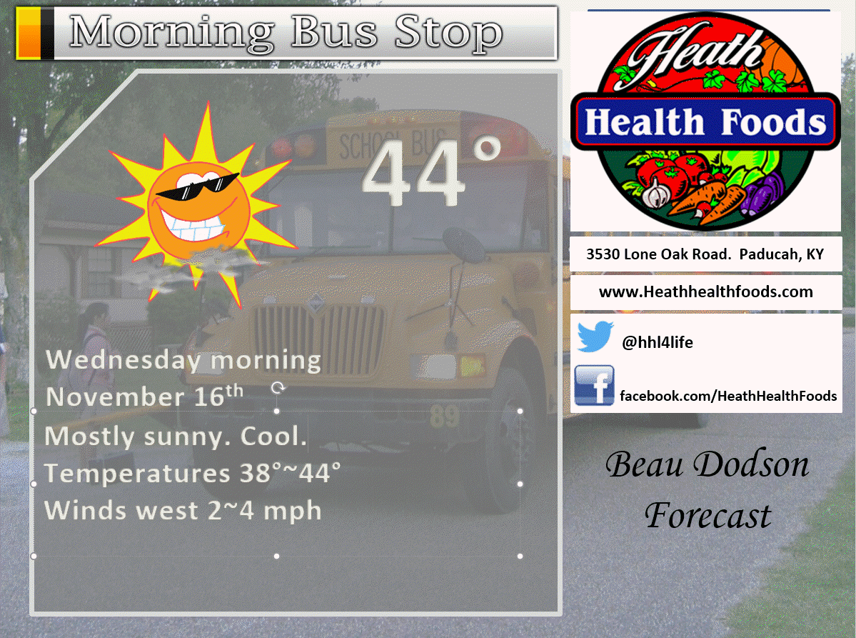
November 16, 2016
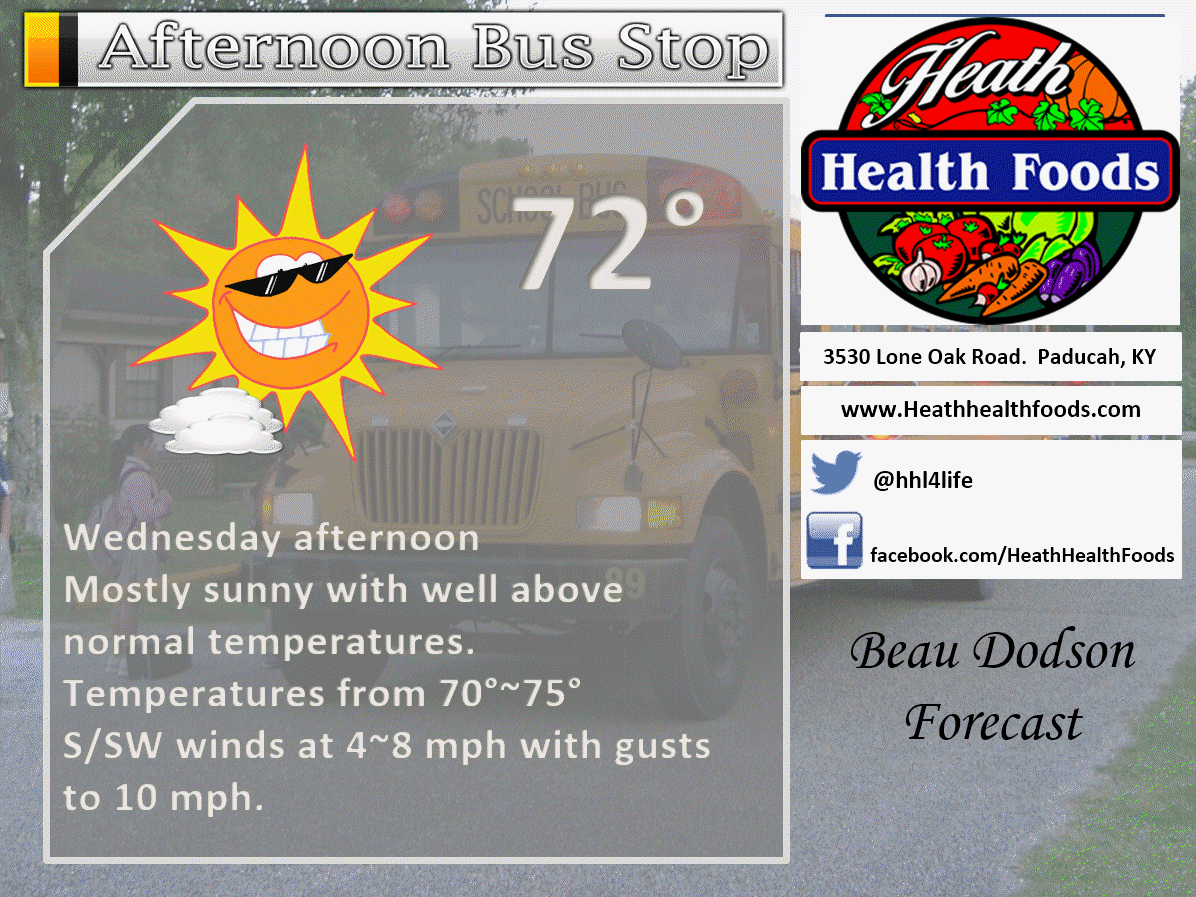
Wednesday: Mostly sunny. Mild. Well above normal temperatures.
What impact is expected? None. Burn bans in effect for many areas.
My confidence in this part of the forecast verifying: High. This forecast should verify.
Temperatures: High temperatures in the 66-74 degree range.
Wind Chill: N/A
Winds: Variable at 4-8 mph. Winds becoming southwest.
What is the chance for precipitation? MO ~ 0%. IL ~ 0%. KY ~ 0% . TN ~ 0%
Coverage of precipitation? None
Is severe weather expected? No
Should I cancel my outdoor plans? No
Sunrise will be at 6:35 a.m. and sunset will be at 4:43 p.m.
UV Index: 3-4
Moonrise will be at 7:10 p.m. and moonset will be at 8:40 a.m. Waning Gibbous
.
Wednesday Night: Mostly clear. Mild for November. Well above normal temperatures.
What impact is expected? None
My confidence in this part of the forecast verifying: High. This forecast should verify.
Temperatures: Lows in the 46-52 degree range.
Wind Chill: N/A
Winds: South and southwest at 2-4 mph
What is the chance for precipitation? MO ~ 0%. IL ~ 0%. KY ~ 0% . TN ~ 0%
Coverage of precipitation: None
Is severe weather expected? No
Should I cancel my outdoor plans? No
.
November 17, 2016
Thursday: Mostly sunny. Mild. Well above normal temperatures. Near record high temperatures.
What impact is expected? None. Burn bans in effect for many areas.
My confidence in this part of the forecast verifying: High. This forecast should verify.
Temperatures: High temperatures in the 75-80 degree range.
Wind Chill: N/A
Winds: Southerly winds at 8-16 mph. Gusty, at times.
What is the chance for precipitation? MO ~ 0%. IL ~ 0%. KY ~ 0% . TN ~ 0%
Coverage of precipitation? None
Is severe weather expected? No
Should I cancel my outdoor plans? No
Sunrise will be at 6:36 a.m. and sunset will be at 4:42 p.m.
UV Index: 4-6
Moonrise will be at 8:10 p.m. and moonset will be at 9:43 a.m. Waning Gibbous
.
Thursday Night: Mostly clear early. Increasing clouds late. A small chance for a shower after 3 am for southeast Missouri.
What impact is expected? Most likely none. Precipitation should hold off until Friday. Small chance late Thursday night over southeast Missouri (towards Poplar Bluff).
My confidence in this part of the forecast verifying: Medium. Some adjustments are possible.
Temperatures: Lows in the 54-56 degree range.
Wind Chill: N/A
Winds: Southerly at 6-12 mph with gusts to 15 mph
What is the chance for precipitation? MO ~ 20%. IL ~ 10%. KY ~ 10% . TN ~ 10%
Coverage of precipitation: Most likely none. I will monitor southern Missouri after 3 am for a few showers.
Is severe weather expected? No
Should I cancel my outdoor plans? No
.
November 18, 2016
Friday: Increasingly cloudy sky conditions. Showers and perhaps some thunderstorms developing as the day wears on. Precipitation will move in from the west. Mild. Well above normal temperatures. Windy, at times. I will need to monitor the timing of the cold front.
What impact is expected? Wet roadways. Perhaps some lightning. Gusty winds.
My confidence in this part of the forecast verifying: Medium. Some forecast adjustments are possible.
Temperatures: High temperatures in the 66-74 degree range.
Wind Chill: N/A
Winds: South and southwest at 10-20 mph with gusts above 30 mph.
What is the chance for precipitation? MO ~ 70%. IL ~ 60%. KY ~ 60% . TN ~ 60%
Coverage of precipitation? Isolated before 7 am and then becoming scattered to widespread through the late morning into the afternoon hours.
Is severe weather expected? Unlikely, but monitor updates.
Should I cancel my outdoor plans? Consider a plan B. I would suggest monitoring radars. Rain is a possibility.
Sunrise will be at 6:37 a.m. and sunset will be at 4:42 p.m.
UV Index: 0-2
Moonrise will be at 9:13 p.m. and moonset will be at 10:37 a.m. Waning Gibbous
.
Friday Night: Mostly cloudy. Showers and thunderstorms possible. Rain will come to an end from west to east Friday night. Turning colder behind the cold front. Gusty winds, at times.
What impact is expected? Wet roadways. Perhaps some lightning. Gusty winds.
My confidence in this part of the forecast verifying: Medium. Some forecast adjustments are possible.
Temperatures: Lows in the 38-44 degree range.
Wind Chill: N/A
Winds: Southwest and west at 8-16 mph. Higher gusts likely. Winds becoming west and northwest late.
What is the chance for precipitation? MO ~ 60%. IL ~ 60%. KY ~ 70% . TN ~ 70%
Coverage of precipitation: Perhaps widespread.
Is severe weather expected? Unlikely, but monitor updates.
Should I cancel my outdoor plans? Have a plan B. Rain is possible. Monitor radars.
.
November 19, 2016
Saturday: Perhaps some morning clouds. Any remaining showers over the Pennyrile area of western Kentucky will end before 8 am. Becoming mostly sunny with patchy clouds. Cooler. Breezy, at times. Below normal temperatures. Cool with the gusty winds.
What impact is expected? Wet roadways (rain should end late Friday night or early Saturday morning)
My confidence in this part of the forecast verifying: Medium. Some forecast adjustments are possible.
Temperatures: High temperatures in the 48-54 degree range.
Wind Chill: 42~46 degrees
Winds: West and northwest winds at 10-20 mph. Gusty, at times.
What is the chance for precipitation? MO ~ 10%. IL ~ 10%. KY ~ 20% . TN ~ 10% Rain should end before 8 am on Saturday morning.
Coverage of precipitation? Most likely no precipitation after sunrise. Small chance of precipitation remaining over our extreme eastern counties.
Is severe weather expected? No
Should I cancel my outdoor plans? No
Sunrise will be at 6:38 a.m. and sunset will be at 4:41 p.m.
UV Index: 2-3
Moonrise will be at 10:15 p.m. and moonset will be at 11:26 a.m. Waning Gibbous
.
Saturday Night: Mostly clear and cold. Starry night.
What impact is expected? None
My confidence in this part of the forecast verifying: Medium. Some forecast adjustments are possible.
Temperatures: Lows in the 26-34 degree range.
Wind Chill: 24~32
Winds: North and northwest at 7-14 mph. Gusty winds are a possibility. Winds lessening after midnight.
What is the chance for precipitation? MO ~ 0%. IL ~ 0%. KY ~ 0% . TN ~ 0%
Coverage of precipitation: None
Is severe weather expected? No
Should I cancel my outdoor plans? No
.
November 20, 2016
Sunday: Mostly sunny and cool. Well below normal temperatures.
What impact is expected? None
My confidence in this part of the forecast verifying: Medium. Some forecast adjustments are possible.
Temperatures: High temperatures in the 46-52 degree range.
Wind Chill: N/A
Winds: North and northwest at 4-8 mph before 12 pm. Winds becoming more west and northwest.
What is the chance for precipitation? MO ~ 0%. IL ~ 0%. KY ~ 0% . TN ~ 0%
Coverage of precipitation? None
Is severe weather expected? No
Should I cancel my outdoor plans? No
Sunrise will be at 6:39 a.m. and sunset will be at 4:41 p.m.
UV Index: 3
Moonrise will be at 11:16 p.m. and moonset will be at 12:07 p.m. Waning Gibbous
.
Sunday Night: Mostly clear. Colder with below normal temperatures.
What impact is expected? None
My confidence in this part of the forecast verifying: Medium. Some forecast adjustments are possible.
Temperatures: Lows in the 22-26 degree range.
Wind Chill: N/A
Winds: West and northwest at 5 mph winds may become southwest late at night.
What is the chance for precipitation? MO ~ 0%. IL ~ 0%. KY ~ 0% . TN ~ 0%
Coverage of precipitation: None
Is severe weather expected? No
Should I cancel my outdoor plans? No
.
November 21, 2016
Monday: Mostly sunny and cool. Well below normal temperatures.
What impact is expected? None
My confidence in this part of the forecast verifying: Medium. Some forecast adjustments are possible.
Temperatures: High temperatures in the 46-52 degree range.
Wind Chill: N/A
Winds: Southwest and west winds at 4-8 mph.
What is the chance for precipitation? MO ~ 0%. IL ~ 0%. KY ~ 0% . TN ~ 0%
Coverage of precipitation? None
Is severe weather expected? No
Should I cancel my outdoor plans? No
Sunrise will be at 6:40 a.m. and sunset will be at 4:40 p.m.
UV Index: 2-3
Moonrise will be at –:– p.m. and moonset will be at 12:44 p.m. Last Quarter.
.
Monday Night: Mostly clear. Perhaps some high clouds after midnight. Not as cold as recent nights.
What impact is expected? None
My confidence in this part of the forecast verifying: Medium. Some forecast adjustments are possible.
Temperatures: Lows in the 30-35 degree range.
Wind Chill: N/A
Winds: Southwest at 3-6 mph.
What is the chance for precipitation? MO ~ 0%. IL ~ 0%. KY ~ 0% . TN ~ 0%
Coverage of precipitation: None
Is severe weather expected? No
Should I cancel my outdoor plans? No
.
November 22, 2016
Tuesday: Increasing clouds. Perhaps a shower.
What impact is expected? Wet roadways (if anything at all)
My confidence in this part of the forecast verifying: Low. Significant adjustments are possible.
Temperatures: High temperatures in the 60-65 degree range.
Wind Chill: N/A
Winds: South and southwest at 6-12 mph. Gusty, at times.
What is the chance for precipitation? MO ~ 20%. IL ~ 20%. KY ~ 20% . TN ~ 20%
Coverage of precipitation?
Is severe weather expected?
Should I cancel my outdoor plans?
Sunrise will be at 6:41 a.m. and sunset will be at 4:40 p.m.
UV Index: 2-3
Moonrise will be at 12:15 a.m. and moonset will be at 1:18 p.m. Waning crescent.
.
Tuesday Night: Cloudy. Showers possible. Breezy, at times.
What impact is expected? Wet roadways.
My confidence in this part of the forecast verifying: Low. Significant adjustments are possible.
Temperatures: Lows in the 48-54 degree range.
Wind Chill: N/A
Winds: South at 8-16 mph.
What is the chance for precipitation? MO ~ 40%. IL ~ 40%. KY ~ 40% . TN ~ 40%
Coverage of precipitation:
Is severe weather expected?
Should I cancel my outdoor plans?
.
November 23, 2016
Wednesday: Cloudy. Showers possible. Low confidence on timing of the precipitation for Tuesday/Wednesday. Monitor updates.
What impact is expected? Wet roadways
My confidence in this part of the forecast verifying: Low. Significant adjustments are possible.
Temperatures: High temperatures in the 60-65 degree range.
Wind Chill: N/A
Winds: South and southwest at 6-12 mph. Winds becoming west at 6-12 mph
What is the chance for precipitation? MO ~ 30%. IL ~ 30%. KY ~ 30% . TN ~ 30%
Coverage of precipitation?
Is severe weather expected?
Should I cancel my outdoor plans?
Sunrise will be at 6:42 a.m. and sunset will be at 4:39 p.m.
UV Index: 2-3
Moonrise will be at 1:12 a.m. and moonset will be at 1:49 p.m. Waning crescent.
.
Wednesday Night: Some clouds. Showers ending. Cooler.
What impact is expected?
My confidence in this part of the forecast verifying: Low. Significant adjustments are possible.
Temperatures: Lows in the 30-35 degree range.
Wind Chill: N/A
Winds: North at 3-6 mph.
What is the chance for precipitation? MO ~ 10%. IL ~ 10%. KY ~ 10% . TN ~ 10%
Coverage of precipitation:
Is severe weather expected?
Should I cancel my outdoor plans?
.
November 24, 2016
Thanksgiving
Thursday: Partly to mostly sunny.
What impact is expected? None
My confidence in this part of the forecast verifying: Low. Significant adjustments are possible.
Temperatures: High temperatures in the 60-65 degree range.
Wind Chill: N/A
Winds: North winds at 4-8 mph.
What is the chance for precipitation? MO ~ 0%. IL ~ 0%. KY ~ 0% . TN ~ 0%
Coverage of precipitation?
Is severe weather expected?
Should I cancel my outdoor plans?
Sunrise will be at 6:43 a.m. and sunset will be at 4:39 p.m.
UV Index: 2-3
Moonrise will be at 2:08 a.m. and moonset will be at 2:19 p.m. Waning crescent.
.
Thursday Night: Clear and cool.
What impact is expected?
My confidence in this part of the forecast verifying: Low. Significant adjustments are possible.
Temperatures: Lows in the 30-35 degree range.
Wind Chill: N/A
Winds: North at 3-6 mph.
What is the chance for precipitation? MO ~ 0%. IL ~ 0%. KY ~ 0% . TN ~ 0%
Coverage of precipitation:
Is severe weather expected?
Should I cancel my outdoor plans?
.
More information on the UV index. Click here
.
The School Bus Stop Forecast is sponsored by Heath Health and Wellness. Located next to Crowell Pools in Lone Oak, Kentucky.
Visit their website here. And. visit Heath Health Foods on Facebook!

Heath Health Foods is a locally owned and operated retail health and wellness store. Since opening in February 2006; the store has continued to grow as a ministry with an expanding inventory which also offers wellness appointments and services along with educational opportunities. Visit their web-site here. And. visit Heath Health Foods on Facebook!
The weekend forecast is sponsored by Farmer and Company Real Estate. Click here to visit their site.
.
Farmer & Company Real Estate is proud to represent buyers and sellers in both Southern Illinois and Western Kentucky. With 13 licensed brokers, we can provide years of experience to buyers & sellers of homes, land & farms and commercial & investment properties. We look forward to representing YOU! Follow us on Facebook, as well

Don’t forget to check out the Southern Illinois Weather Observatory web-site for weather maps, tower cams, scanner feeds, radars, and much more! Click here

An explanation of what is happening in the atmosphere over the coming days
- WELL above normal temperatures to continue through Friday
- Strong cold front arrives on Friday and Friday night
- Below normal temperatures Saturday through Monday
- Coldest air of the season, thus far?
- More rain possible Tuesday and Wednesday (system appears to be arriving faster than earlier thinking)
- No snow, yet
Wow. What can I say. November is a repeat of October. Warm temperatures cover most of the nation. Well above normal temperatures in some instances. What a peculiar autumn this has been. Certainly a warm one. The lack of weather has also been odd. Drought conditions continue to spread across the region.
Like all good things, this too must come to an end. It can’t be warm forever (well, I guess it COULD, but it won’t). There are changes starting to show up in the weather maps. There is at least a chance we are about to enter a cooler and more active pattern. Fingers and toes crossed. Drought encompasses much of the region. Wild fires have been out of control over portions of the Ohio and Tennessee Valleys. Rain has been absent from the forecast for weeks at a time. Is all of that about to change?
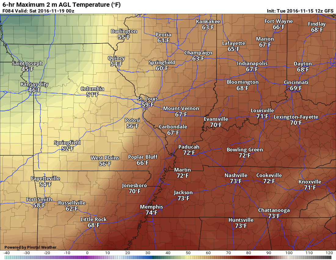
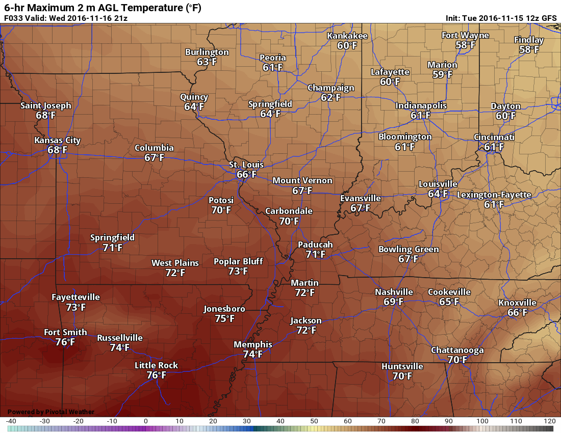
We have several more warm days ahead of us. Temperatures on Wednesday, Thursday, and Friday will be warm. The warmest day will likely be Thursday. Temperatures on Thursday should peak from 75-80 degrees. This could bring down some records.
Here is the record high temperature potential map for Thursday. Where you see a white circle is where record high temperatures are possible. We will be close.
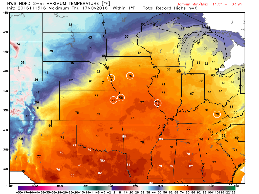
Normal high temperatures, for this time of the year, are around 56 degrees. Normal lows are around 36-38 degrees.
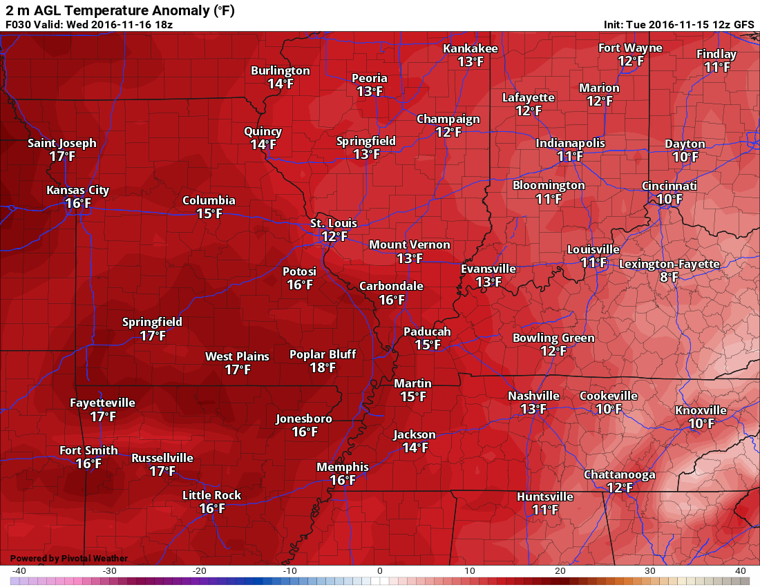
How many degrees above normal will temperatures be on Wednesday and Thursday. Let’s go to the anomaly maps.
This first map is for Wednesday. As you can see, we will be WELL above normal. Anywhere from 13 to 18 degrees above normal.
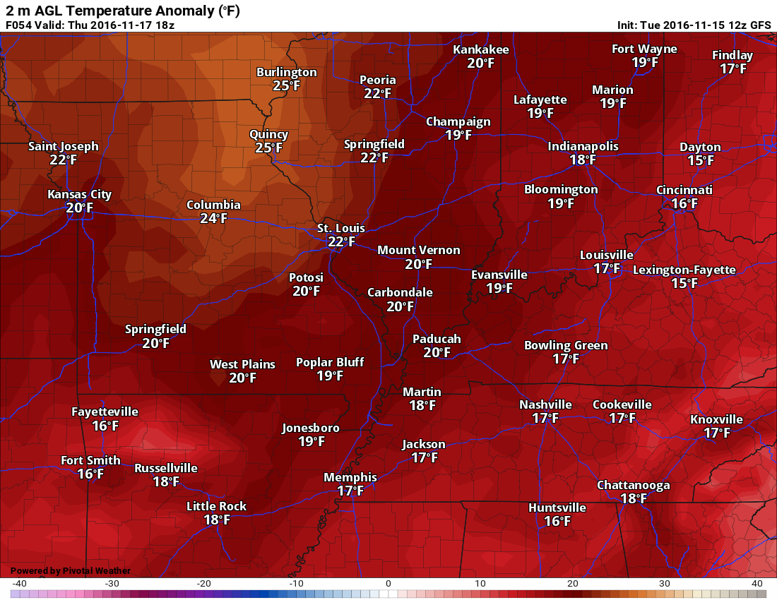
This next map is for Thursday. The anomalies on Thursday will be higher than Wednesday. Check out all of the 20+ degree readings. WELL above normal temperatures.
Changes coming:
High confidence on a cold front arriving on Friday and Friday night.
A strong cold front will push through the region on Friday and Friday night. This will bring an end to the warm temperatures (at least temporarily).
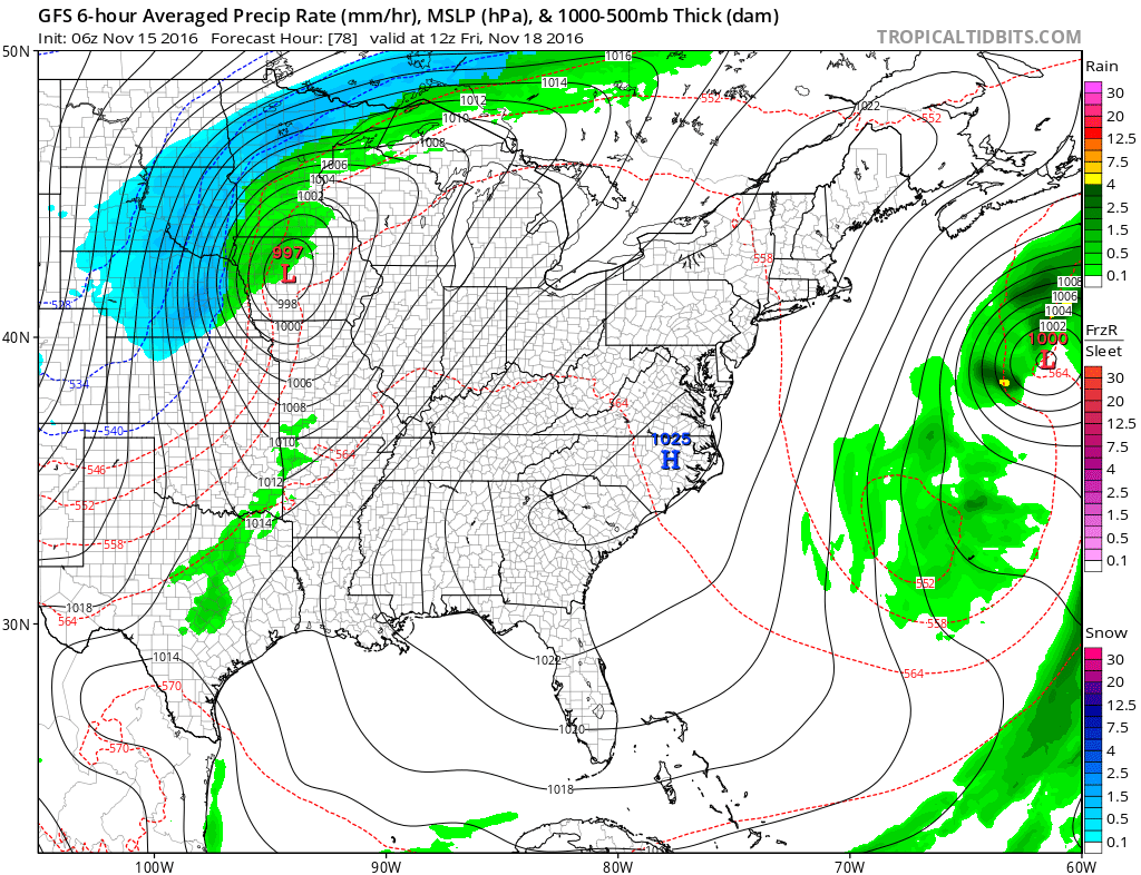
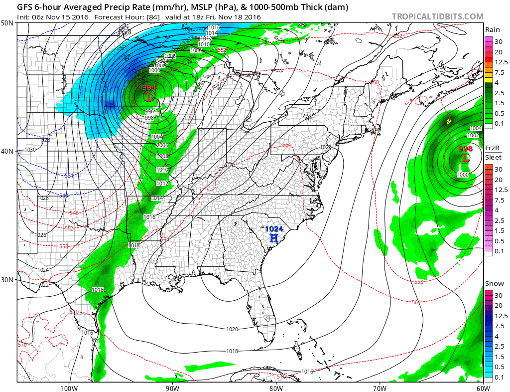
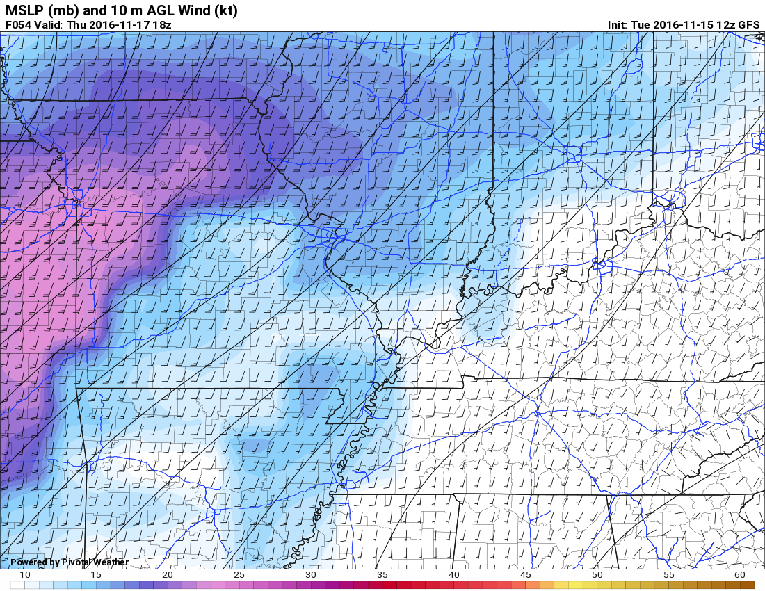
Let’s take a look at the GFS model guidance. You can see the area of low pressure well to our north (this first image shows the low over Iowa). The band of green and dark green represents showers and thunderstorms. The blue, to the north, represents a snow event. Perhaps even a blizzard! Road trip, anyone?
Let’s walk through the maps.
The colors represent precipitation totals for the previous six hours. For example: This first map is for 7 am on Friday morning. The light green represents precipitation that fell from 12 am Friday through 6 am Friday.
These are surface maps. This first image is for 6 am on Friday. Nice snowstorm well to our northwest! Rain just starting to get its act together to our west. The whole system will push east/northeast into Friday night. Notice the tight isobars? Isobars are equal lines of pressure. Tight pressure gradients equal strong and gusty winds. The highest winds will be closer to the area of low pressure. Look at how tight the isobars are over the Dakota’s. Blizzard conditions are possible.
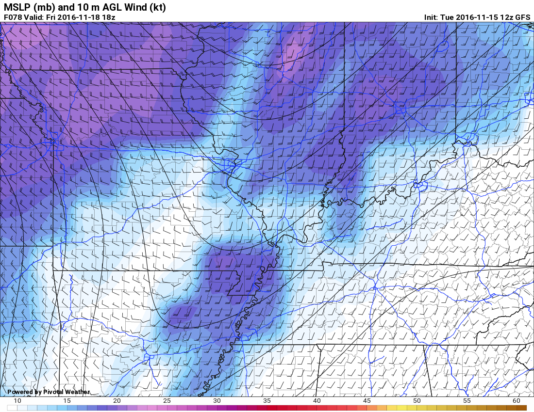
This next image is for Friday noon. You can see the rain continues to develop to our west. Precipitation will shift eastward through the afternoon.
Perhaps a few showers into our region by late morning and early afternoon. I will need to monitor the exact timing of the front.
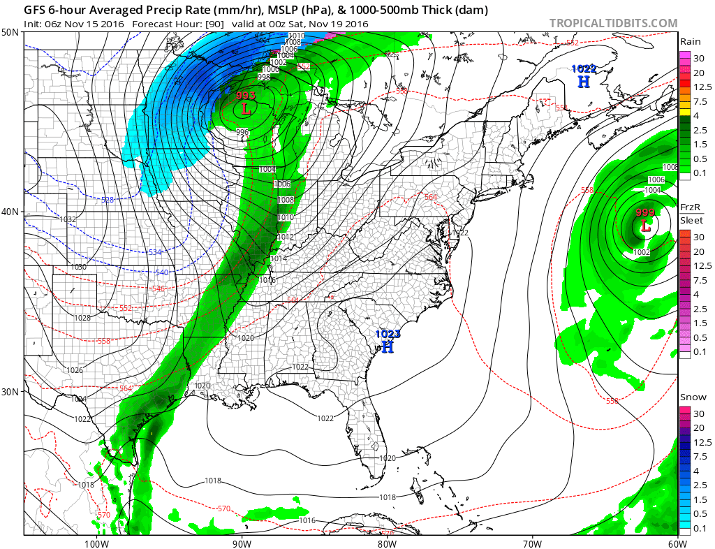
This next image is for Friday evening around 6 pm. The low is over northern Wisconsin. Heavy wind driven snow is falling over northeast Minnesota into extreme northwest Wisconsin. A band of showers and thunderstorms extends along a cold front from Wisconsin into Missouri and Illinois.
Rain showers and thunderstorms will be possible in our region. Most of the precipitation should fall from Friday afternoon into the first half of Friday night.
The dark green colors represent precipitation totals from 12 pm Friday through 6 pm Friday. GFS is showing a decent rain event. The scale shows dark green as 1″ or more. We will see. The GFS is heavier than most of the guidance. Let’s hope it is right, but plan on rain totals being less than one inch (for most of the area).
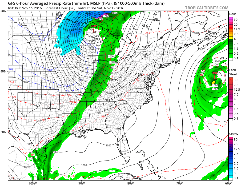
This next image is for Friday night around 11 pm to 12 am on Saturday morning. Precipitation totals from 6 pm Friday through 12 am Saturday. Rain should exit the region late Friday night.
The band of rain should be on the way out by late Friday night. Ending from west to east. That means the Pennyrile area of western Kentucky will experience rain longer than southeast Missouri.
The good news is that severe weather is not anticipated.
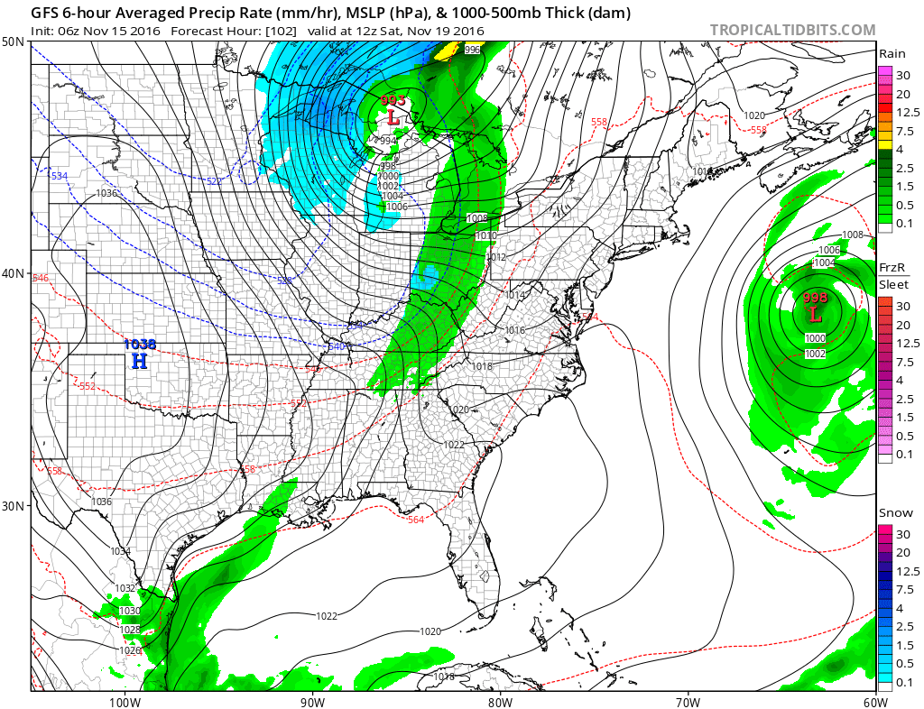
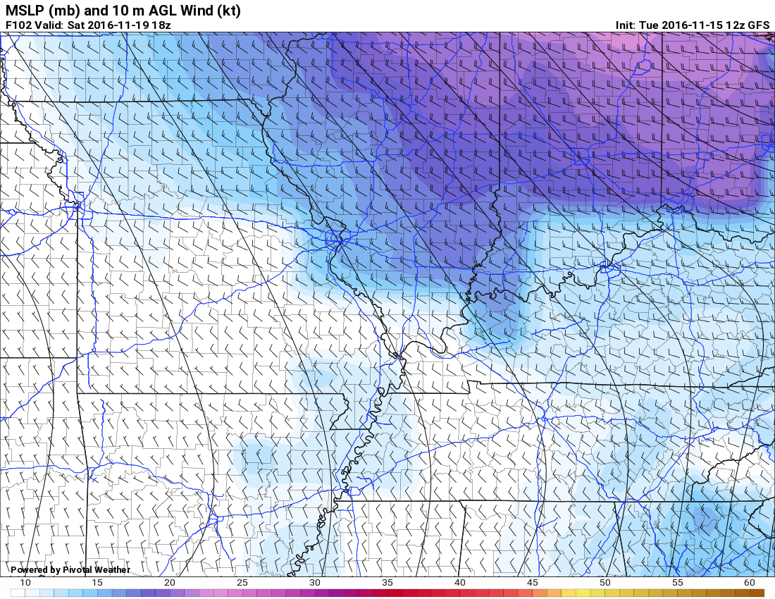
This next image is for 6 am on Saturday. The rain should have ended by this time. It is well to our east. Some light snow is even possible across portions of central and eastern Kentucky. That would occur as colder air arrives behind the cold front.
Tight isobars (equal lines of pressure) will mean gusty winds on both Friday and Saturday. Winds may gust over 30 mph from time to time.
Gusty winds are possible on Thursday, Friday, and Saturday. Here are some of the wind forecast maps. Scale is on the bottom of the graphic.
Thursday will deliver some 10-15 mph gusts. Higher gusts are possible.
Friday you can expect 10-20 mph winds with gusts to 30 mph (or more).
Saturday will deliver some chilly winds. Winds from 10-15 mph are possible. Higher gusts are likely, especially over our northern counties.
Cooling down behind the cold front
Colder air will follow frontal passage. Check out the Friday afternoon temperature gradient over Missouri.
Much cooler air will follow the cold front. We may remain in the 40’s on Saturday and Sunday. That would be high temperatures! Brrr
Overnight lows will be quite chilly Saturday, Sunday, and Monday morning.
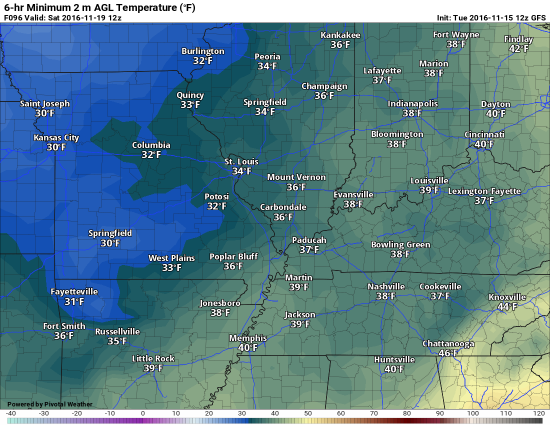
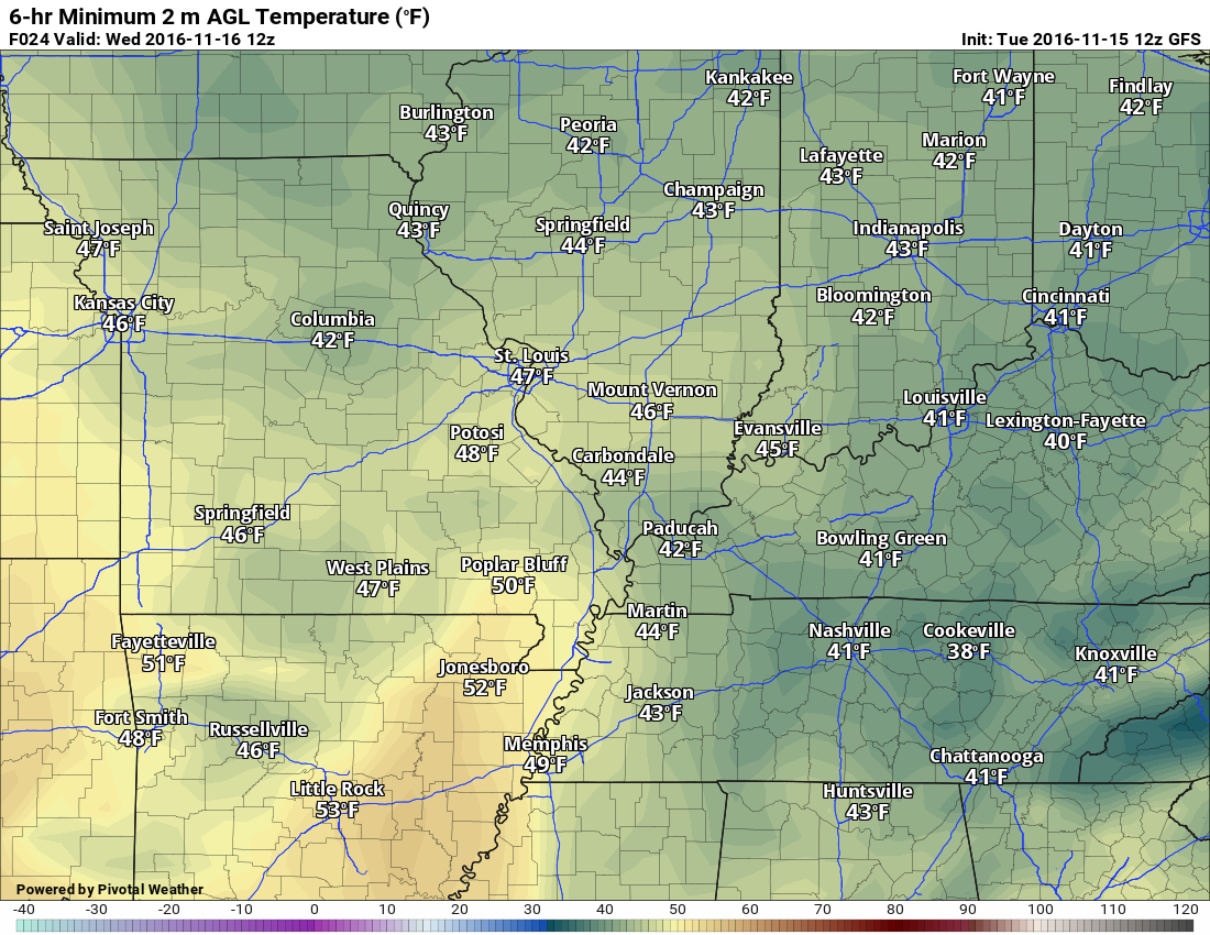
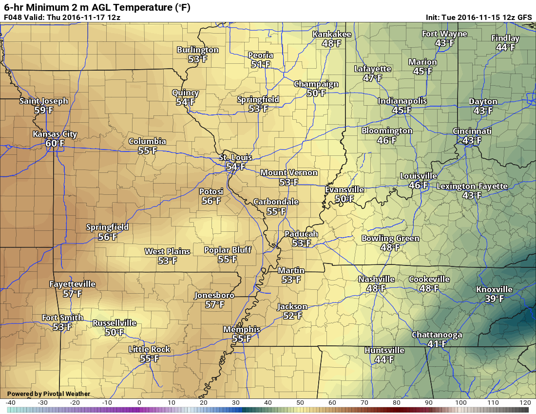
Let’s walk through the low temperatures.
This first graphic is for Saturday morning.
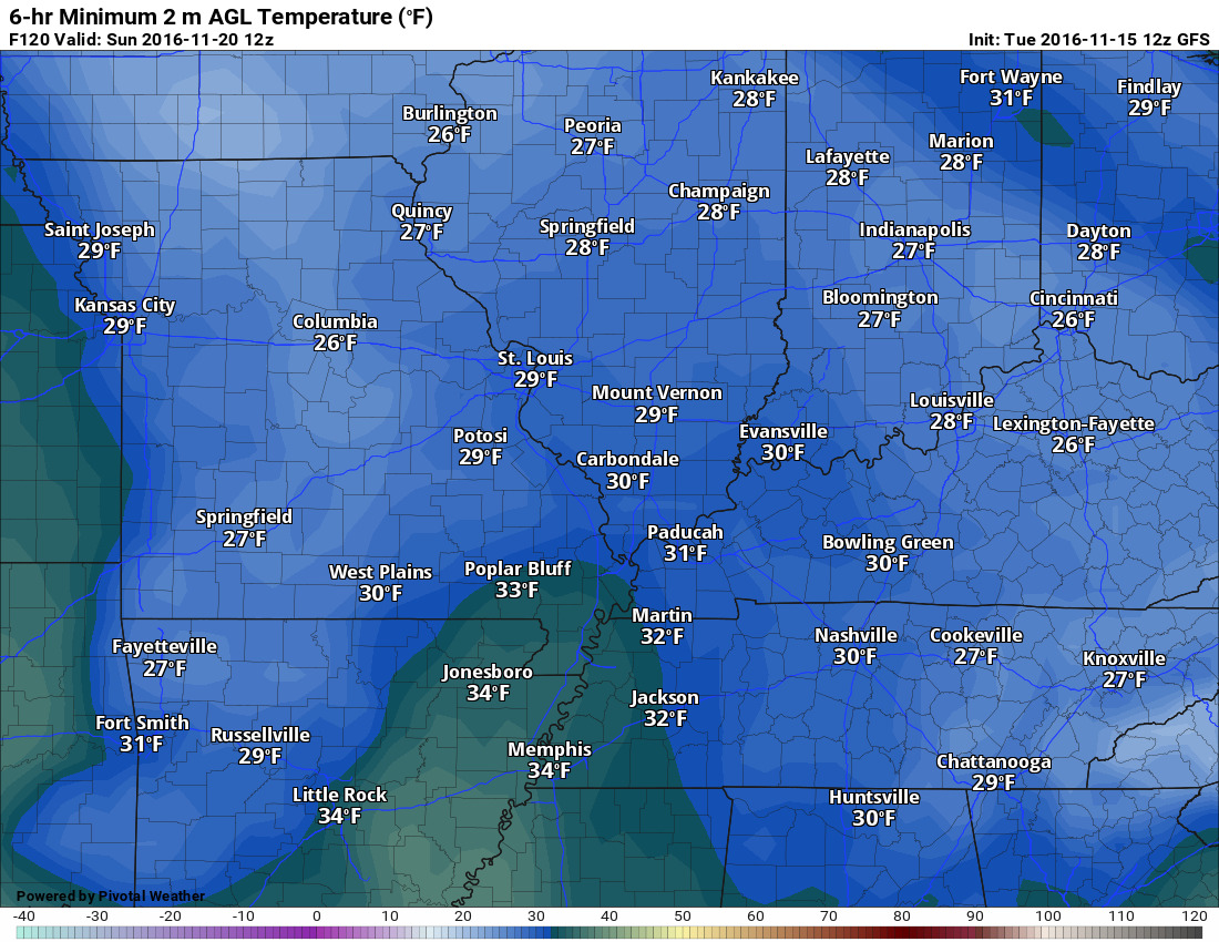
This next graphic is for Sunday morning
The GFS is not as cold as some other model guidance. Let’s keep an eye on it. This is what it is showing.
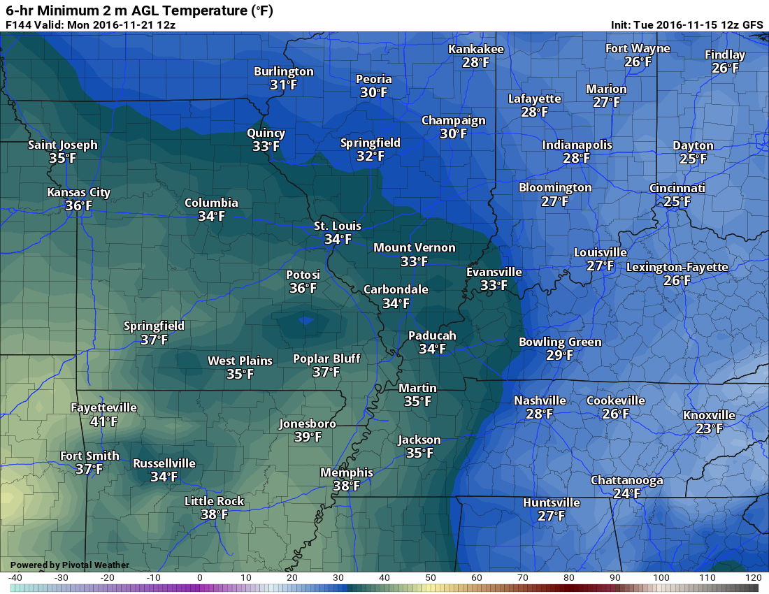
This is for Monday morning. Again, this may be too warm. We shall see.
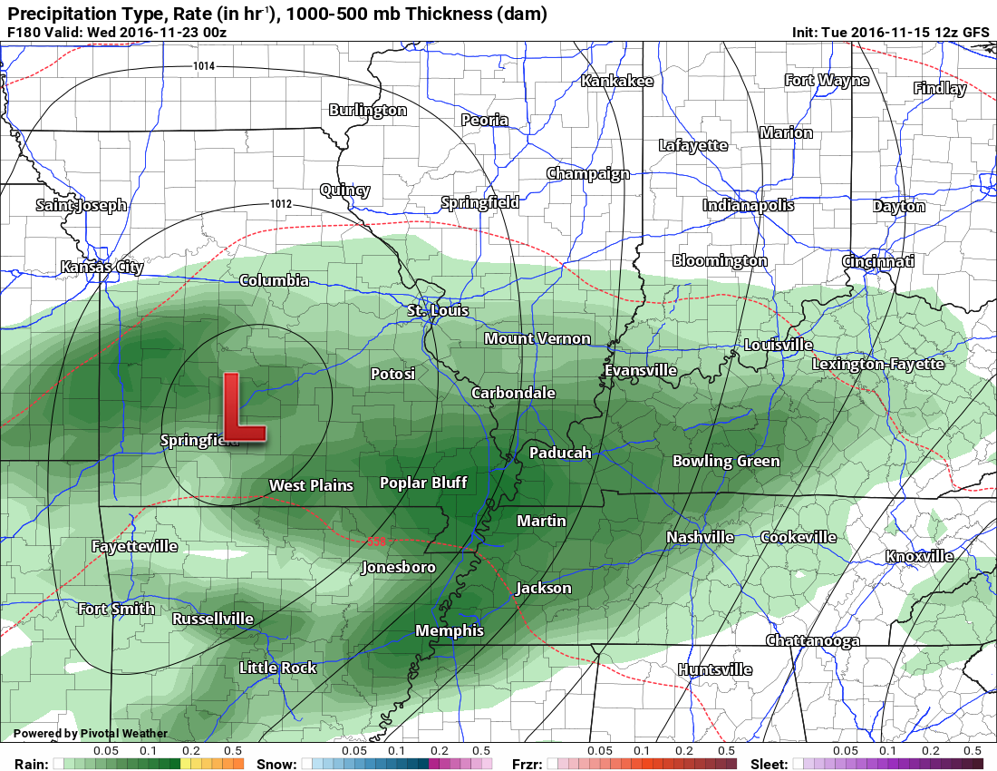
Another system next week:
Another storm system will approach our region by Tuesday or Wednesday of next week. Still some time to work out the details. It should be a rain maker for our region.
There remain some questions on timing. Some of the guidance brings it into the area on Tuesday/Tuesday night and other guidance holds off until Tuesday night into Wednesday night.
You can see the system taking shape on Tuesday morning. It will approach our region from the southwest. If this was December or January we would be talking about snow and ice changing to rain.
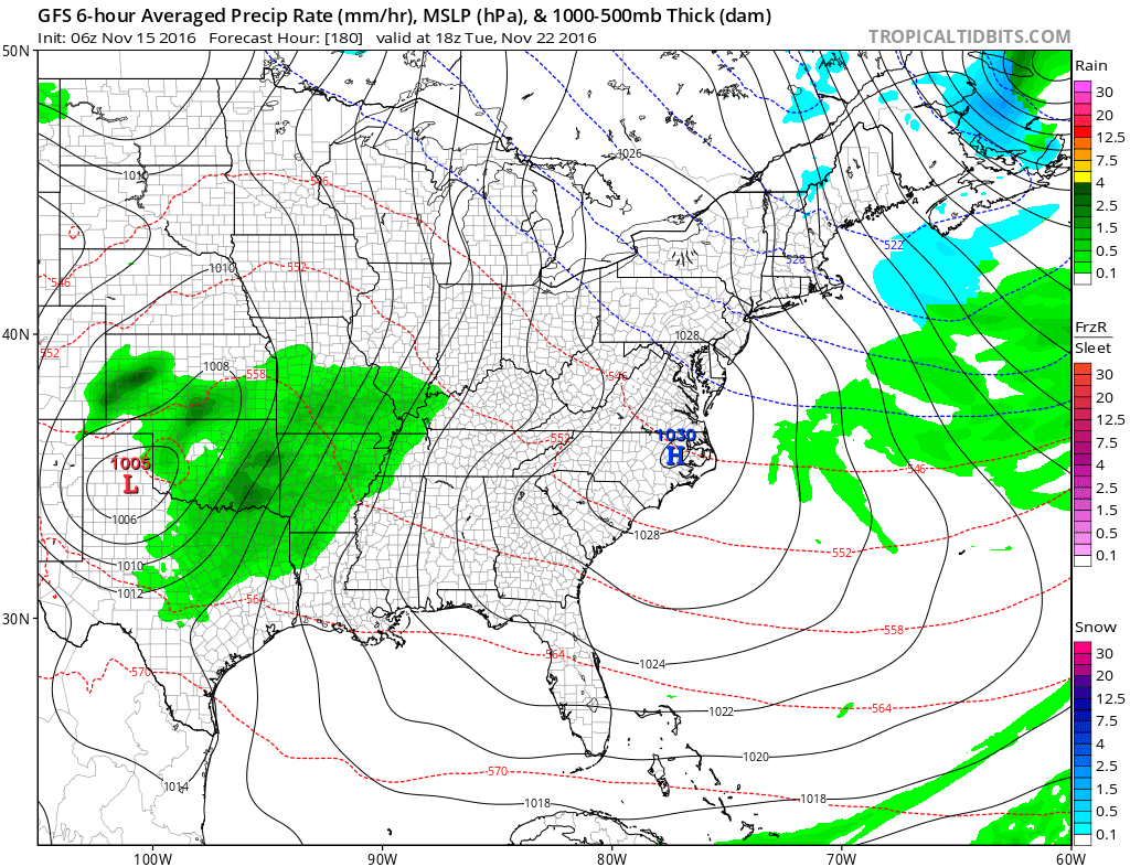
The system pulls into our region Tuesday afternoon and night. At least according to the GFS and EC model guidance.
Let’s zoom in a bit.
You can see the area of low pressure on Tuesday evening over Missouri. The low will move northeast. Showers and perhaps some thunder in our local area.
Again, timing is questionable. It might arrive later vs earlier. Keep that in mind.
Click images to enlarge
Moving ahead to late Tuesday night
You can see the low near St Louis by 11 pm Tuesday night and 12 am Wednesday morning. Rain in our region.
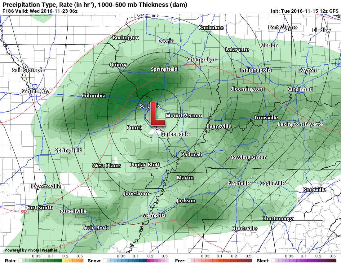
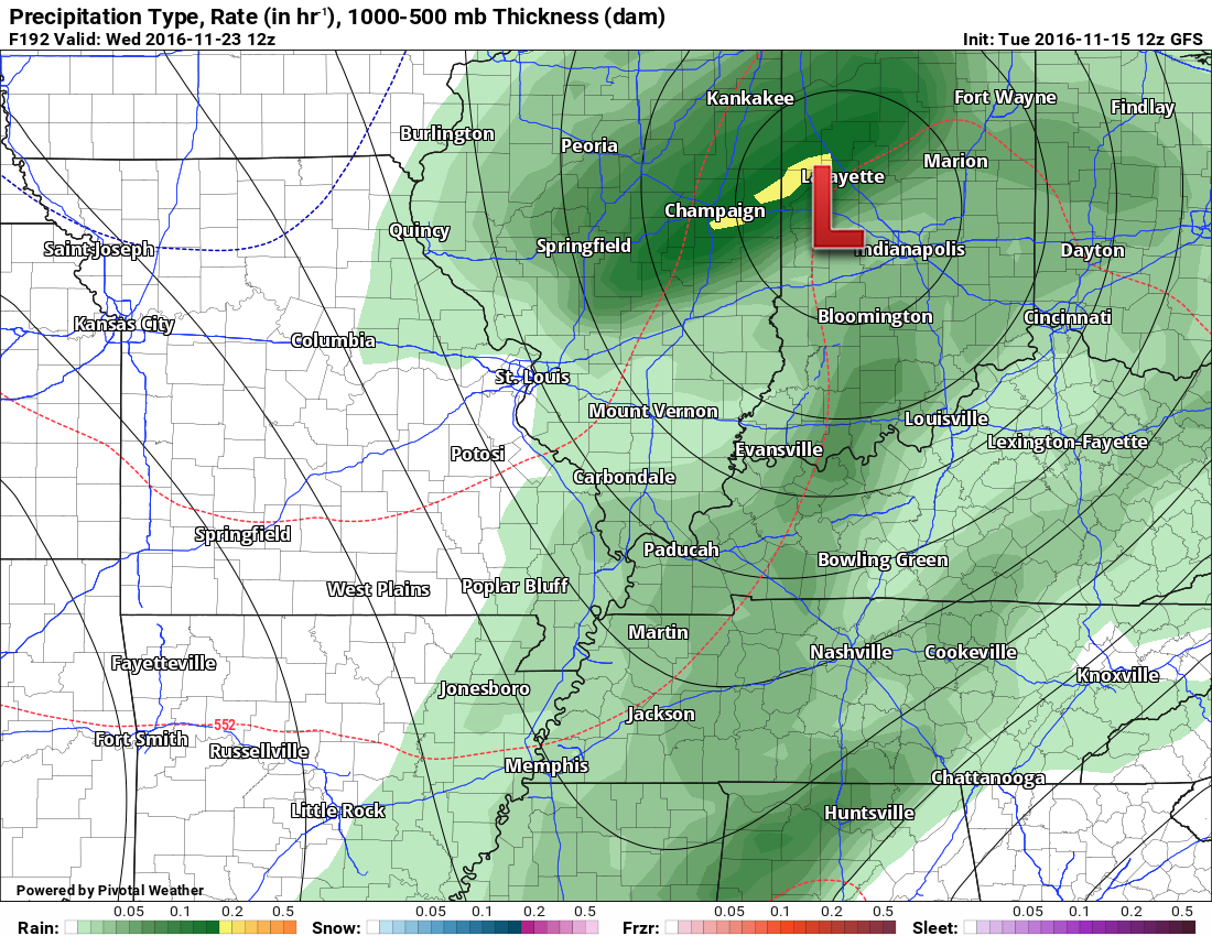
This next image is Wednesday morning. This is for the 6 am time frame. You can see the low pulling into Indiana. Cold front will push through our region late Tuesday night and Wednesday morning.
Colors represent rainfall totals from the previous six hours.
The GFS is bullish on rainfall totals for system number two. Is it too bullish? Let’s monitor trends.
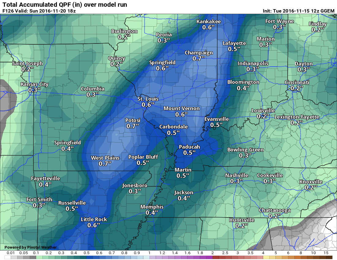
Here are rainfall totals for Tuesday and Wednesday.
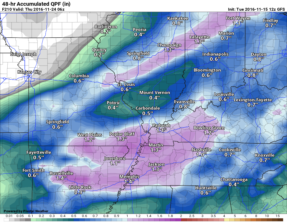
If you were to add the Friday and Tuesday/Wednesday system together then you would come up with these rainfall totals
The GFS is bullish. It is more bullish than other model guidance. Let’s monitor the trends and plan on 0.50″ to 1.00″ for both systems combined. If it ends up being more then that would be GREAT!
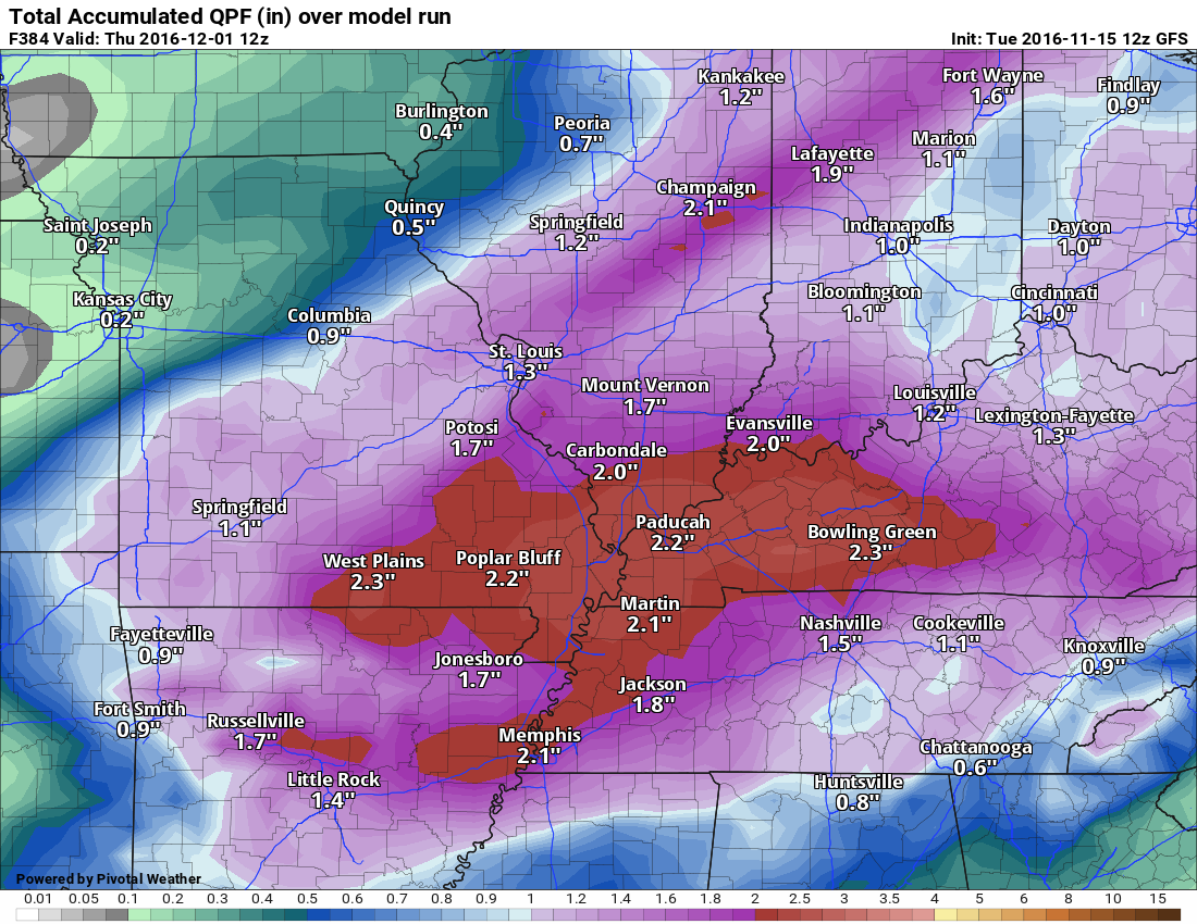
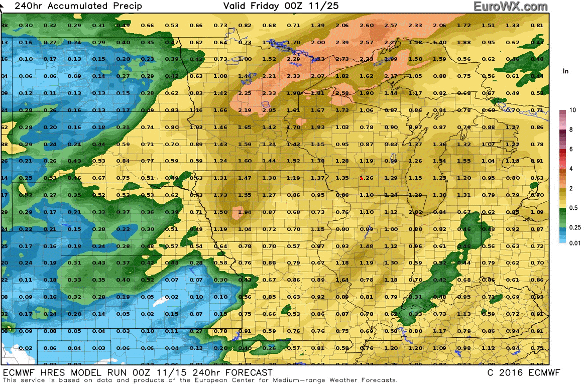
Here is what the EC model guidance is showing. It has entire event totals quite a bit less than the GFS.
Click images to enlarge
.
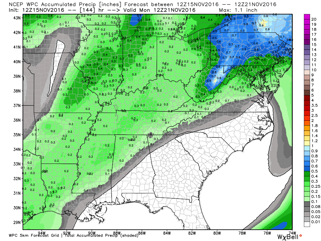
How much rain is NOAA/WPC forecasting over the coming days?
I am monitoring a storm system for Friday into Friday night. It does appear that measurable rain is likely during this time frame.
Here is the official WPC/NOAA forecast map
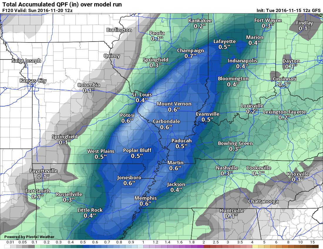
This is for the weekend system only
Here are two models. The first one is the GFS and the second one is the GEM. These are rainfall totals for the weekend system.
GFS rainfall totals
GEM rainfall totals
GEM model guidance is more bullish than the GFS
This is for system one (does not include the system for Tuesday and Wednesday of next week)
.
Wednesday morning low temperatures
.
.
Wednesday afternoon 4 pm temperatures
.
.
.
.
.
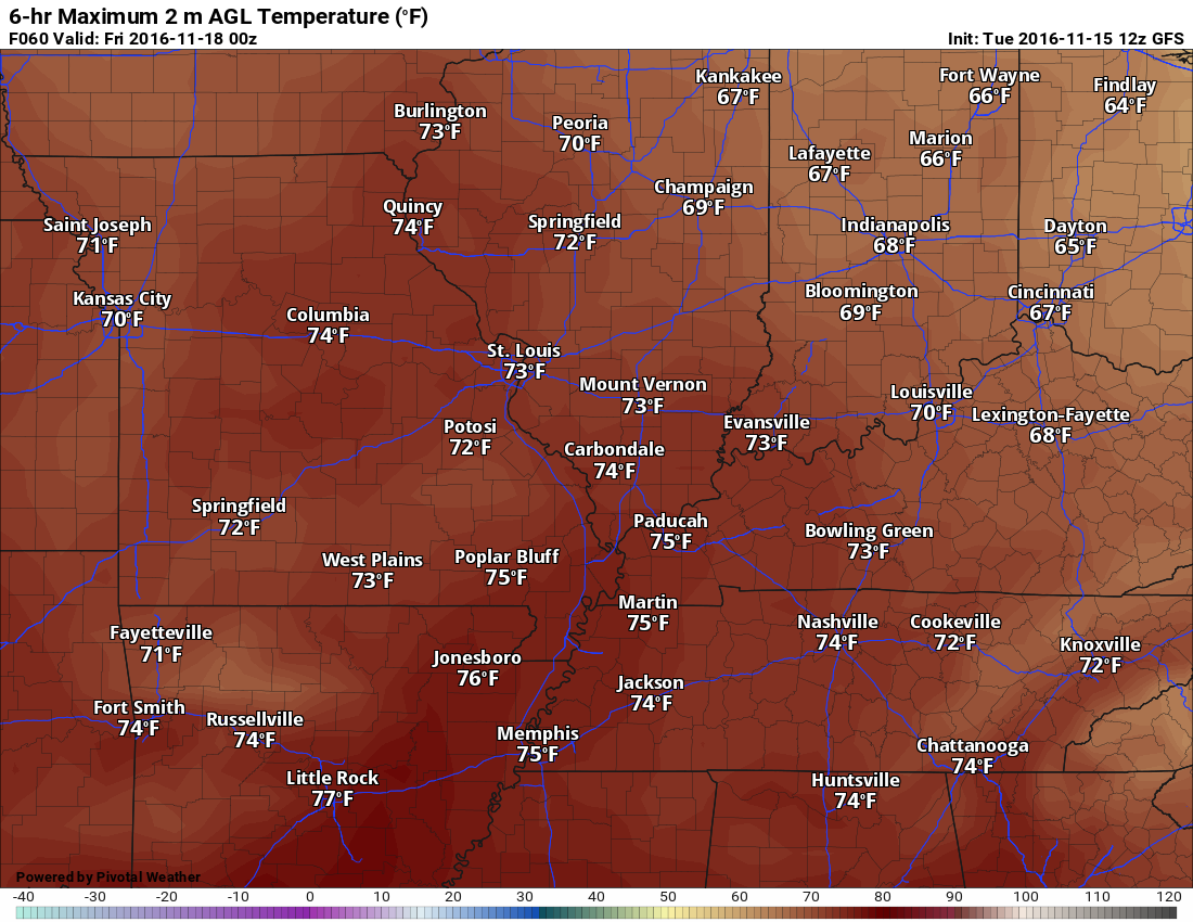
Thursday afternoon temperatures at 4 pm
..
 .
.

We have regional radars and local city radars – if a radar does not seem to be updating then try another one. Occasional browsers need their cache cleared. You may also try restarting your browser. That usually fixes the problem. Occasionally we do have a radar go down. That is why I have duplicates. Thus, if one fails then try another one.
If you have any problems then please send me an email beaudodson@usawx.com
WEATHER RADAR PAGE – Click here —
We also have a new national interactive radar – you can view that radar by clicking here.
Local interactive city radars include St Louis, Mt Vernon, Evansville, Poplar Bluff, Cape Girardeau, Marion, Paducah, Hopkinsville, Memphis, Nashville, Dyersburg, and all of eastern Kentucky – these are interactive radars. Local city radars – click here

Live Lightning Data – zoom and pan: Click here
Live Lightning Data with sound (click the sound button on the left side of the page): Click here

Can we expect severe thunderstorms over the next 24 to 48 hours? Remember that a severe thunderstorm is defined as a thunderstorm that produces 58 mph winds or higher, quarter size hail or larger, and/or a tornado.
.
Tuesday night through Thursday night: Severe weather is not anticipated.
Friday into Friday night: Thunderstorms are possible as a cold front nears the region. I can’t rule out strong storms. Let’s keep an eye on it.
Saturday the 19th through Tuesday the 22nd: Severe weather is not anticipated.
.

No major adjustments.

No major concerns. Perhaps some lightning on Friday and Friday night.
.
..
.


.
The latest 8-14 day temperature and precipitation outlook. Note the dates are at the top of the image. These maps DO NOT tell you how high or low temperatures or precipitation will be. They simply give you the probability as to whether temperatures or precipitation will be above or below normal.
.

 .
..

Here are the current river stage forecasts. You can click your state and then the dot for your location. It will bring up the full forecast and hydrograph.

Who do you trust for your weather information and who holds them accountable?
I have studied weather in our region since the late 1970’s. I have 38 years of experience in observing our regions weather patterns. I hold a Bachelor’s of Science in Geo-sciences with a concentration in Broadcast Meteorology. I graduated from Mississippi State University.
My resume includes:
Member of the American Meteorological Society.
NOAA Weather-Ready Nation Ambassador.
Meteorologist for McCracken County Rescue Squad. I served from 2005 through 2015
Meteorologist for the McCracken County Rescue Squad 2015-current
I own and operate the Southern Illinois Weather Observatory.
Recipient of the Mark Trail Award, WPSD Six Who Make A Difference Award, Kentucky Colonel, and the Caesar J. Fiamma” Award from the American Red Cross.
In 2009 I was presented with the Kentucky Office of Highway Safety Award.
Recognized by the Kentucky House of Representatives for my service to the State of Kentucky leading up to several winter storms and severe weather outbreaks.
I am also President of the Shadow Angel Foundation which serves portions of western Kentucky and southern Illinois.
There is a lot of noise on the internet. A lot of weather maps are posted without explanation. Over time you should learn who to trust for your weather information.
My forecast philosophy is simple and straight forward.
- Communicate in simple terms
- To be as accurate as possible within a reasonable time frame before an event
- Interact with you on Twitter, Facebook, and the blog
- Minimize the “hype” that you might see on television or through other weather sources
- Push you towards utilizing wall-to-wall LOCAL TV coverage during severe weather events
I am a recipient of the Mark Trail Award, WPSD Six Who Make A Difference Award, Kentucky Colonel, and the Caesar J. Fiamma” Award from the American Red Cross. In 2009 I was presented with the Kentucky Office of Highway Safety Award. I was recognized by the Kentucky House of Representatives for my service to the State of Kentucky leading up to several winter storms and severe weather outbreaks.
If you click on the image below you can read the Kentucky House of Representatives Resolution.

Many of my graphics are from www.weatherbell.com – a great resource for weather data, model data, and more


You can sign up for my AWARE email by clicking here I typically send out AWARE emails before severe weather, winter storms, or other active weather situations. I do not email watches or warnings. The emails are a basic “heads up” concerning incoming weather conditions.