
.
December 12, 2017
Tuesday Night Forecast Details:
Forecast: Mostly clear. A few passing clouds. Cold.
Temperatures: MO ~ 20 to 25 IL ~ 20 to 25 KY ~ 23 to 26
Wind chill values: 16 to 24 degrees
Accumulating snow or ice: No
Winds: Northwest winds 5 to 10 mph with gusts to 14 mph becoming west and southwest late
What impacts are anticipated from the weather? None
My confidence in the forecast verifying: High
Is severe weather expected? No
The NWS defines severe weather as 58 mph wind or great, 1″ hail or larger, and/or tornadoes
Is freezing rain, sleet, or snow expected? None
What is the chance of precipitation? MO ~ 0% IL ~ 0% KY ~ 0%
Coverage of precipitation: None
Should I cancel my outdoor plans: No
.
December 13, 2017
Wednesday Forecast Details
Forecast: Mostly sunny. Some passing clouds. Breezy. Cool temperatures.
Temperatures: MO ~ 48 to 54 IL ~ 45 to 50 KY ~ 48 to 52
Wind chill values: N/A
Accumulating snow or ice: No
Winds: South and southwest winds at 15 to 30 mph with higher gusts possible.
What impacts are anticipated from the weather? None
My confidence in the forecast verifying: High
Is severe weather expected? No
The NWS defines severe weather as 58 mph wind or great, 1″ hail or larger, and/or tornadoes
Is freezing rain, sleet, or snow expected? No
What is the chance of precipitation? MO ~ 0% IL ~ 0% KY ~ 0%
Coverage of precipitation: None
Should I cancel my outdoor plans? No
.
Wednesday Night Forecast Details:
Forecast: A few clouds. Chilly.
Temperatures: MO ~ 28 to 33 IL ~ 26 to 32 KY ~ 28 to 34
Wind chill values: 25 to 35 degrees
Accumulating snow or ice: No
Winds: West and northwest winds 7 to 14 mph. Winds may become variable in direction.
What impacts are anticipated from the weather? Most likely none
My confidence in the forecast verifying: High
Is severe weather expected? No
The NWS defines severe weather as 58 mph wind or great, 1″ hail or larger, and/or tornadoes
Is freezing rain, sleet, or snow expected? None
What is the chance of precipitation? MO ~ 10% IL ~ 10% KY ~ 10%
Coverage of precipitation: None to isolated
Should I cancel my outdoor plans: No
.
December 14, 2017
Thursday Forecast Details
Forecast: Quite a few clouds. Chilly temperatures.
Temperatures: MO ~ 40 to 45 IL ~ 38 to 44 KY ~ 42 to 46
Wind chill values: 35 to 40
Accumulating snow or ice: No
Winds: West and northwest at 5 to 10 mph
What impacts are anticipated from the weather? None
My confidence in the forecast verifying: High
Is severe weather expected? No
The NWS defines severe weather as 58 mph wind or great, 1″ hail or larger, and/or tornadoes
Is freezing rain, sleet, or snow expected? No
What is the chance of precipitation? MO ~ 0% IL ~ 0% KY ~ 0%
Coverage of precipitation: None
Should I cancel my outdoor plans? No
.
Thursday Night Forecast Details:
Forecast: Partly cloudy. Snow showers or rain showers possible.
Temperatures: MO ~ 24 to 28 IL ~ 24 to 28 KY ~ 24 to 28
Wind chill values: 20 to 25
Accumulating snow or ice: No
Winds: Northwest winds 5 to 10 mph
What impacts are anticipated from the weather? Perhaps wet roadways.
My confidence in the forecast verifying: LOW
Is severe weather expected? No
The NWS defines severe weather as 58 mph wind or great, 1″ hail or larger, and/or tornadoes
Is freezing rain, sleet, or snow expected? None
What is the chance of precipitation? MO ~ 30% IL ~ 30% KY ~ 30%
Coverage of precipitation: Isolated to perhaps scattered
Should I cancel my outdoor plans: No
.
December 15, 2017
Friday Forecast Details
Forecast: Morning clouds. A slight chance of a shower or snow shower before 10 am.
Temperatures: MO ~ 40 to 45 IL ~ 36 to 44 KY ~ 40 to 45
Wind chill values: 35 to 40
Accumulating snow or ice: Unlikely
Winds: West and northwest at 5 to 10 mph with gusts to 15 mph
What impacts are anticipated from the weather? Perhaps wet roadways. Low risk.
My confidence in the forecast verifying: LOW
Is severe weather expected? No
The NWS defines severe weather as 58 mph wind or great, 1″ hail or larger, and/or tornadoes
Is freezing rain, sleet, or snow expected? Monitor updates
What is the chance of precipitation? MO ~ 20% IL ~ 20% KY ~ 20%
Coverage of precipitation: Isolated (if anything)
Should I cancel my outdoor plans? No
.
Friday Night Forecast Details:
Forecast: Mostly clear. Cold.
Temperatures: MO ~ 25 to 30 IL ~ 25 to 30 KY ~ 28 to 34
Wind chill values: 20’s
Accumulating snow or ice: No
Winds: South and southwest winds 4 to 8 mph
What impacts are anticipated from the weather? None
My confidence in the forecast verifying: Medium
Is severe weather expected? No
The NWS defines severe weather as 58 mph wind or great, 1″ hail or larger, and/or tornadoes
Is freezing rain, sleet, or snow expected? None
What is the chance of precipitation? MO ~ 0% IL ~ 0% KY ~ 0%
Coverage of precipitation: None
Should I cancel my outdoor plans: No
.
December 16, 2017
Saturday Forecast Details
Forecast: Partly sunny. Warmer.
Temperatures: MO ~ 52 to 56 IL ~ 50 to 55 KY ~ 52 to 56
Wind chill values: N/A
Accumulating snow or ice: No
Winds: South and southwest winds 8 to 16 mph
What impacts are anticipated from the weather? None
My confidence in the forecast verifying: Medium
Is severe weather expected? No
The NWS defines severe weather as 58 mph wind or great, 1″ hail or larger, and/or tornadoes
Is freezing rain, sleet, or snow expected? No
What is the chance of precipitation? MO ~ 10% IL ~ 10% KY ~ 10%
Coverage of precipitation: None
Should I cancel my outdoor plans? No
.
Saturday Night Forecast Details:
Forecast: Becoming cloudy. Breezy. Showers increasing from the south and west.
Temperatures: MO ~ 35 to 40 IL ~ 35 to 40 KY ~ 35 to 40
Wind chill values: 30 to 40
Accumulating snow or ice: No
Winds: South and southwest winds 7 to 14 mph with gusts to 25 mph
What impacts are anticipated from the weather? Wet roadways
My confidence in the forecast verifying: Medium
Is severe weather expected? No
The NWS defines severe weather as 58 mph wind or great, 1″ hail or larger, and/or tornadoes
Is freezing rain, sleet, or snow expected? None
What is the chance of precipitation? MO ~ 60% IL ~ 60% KY ~ 60%
Coverage of precipitation:Increasing coverage from the south and west.
Should I cancel my outdoor plans: No
.
December 17, 2017
Sunday Forecast Details
Forecast: Mostly cloudy. Rain likely, especially the first half of the day. Lesser rain chances during the afternoon. Rain ends last over the Pennyrile area of western Kentucky. Cool with the clouds and rain.
Temperatures: MO ~ 46 to 54 IL ~ 46 to 54 KY ~ 46 to 54
Wind chill values: N/A
Accumulating snow or ice: No
Winds: Southwest becoming west and northwest at 6 to 12 mph with gusts to 18 mph
What impacts are anticipated from the weather? Wet roadways
My confidence in the forecast verifying: Medium
Is severe weather expected? No
The NWS defines severe weather as 58 mph wind or great, 1″ hail or larger, and/or tornadoes
Is freezing rain, sleet, or snow expected? No
What is the chance of precipitation? MO ~ 70% IL ~ 70% KY ~ 80%
Coverage of precipitation: Widespread first half of the day
Should I cancel my outdoor plans? Have a plan B
.
Sunday Night Forecast Details:
Forecast: Partly cloudy. A slight chance of rain showers or flurries. Most of the precipitation should have ended.
Temperatures: MO ~ 30 to 35 IL ~ 30 to 35 KY ~ 30 to 35
Wind chill values: 20’s and 30’s
Accumulating snow or ice: No
Winds: West and northwest winds 5 to 10 mph with gusts to 15 mph
What impacts are anticipated from the weather? Wet roadways
My confidence in the forecast verifying: Medium
Is severe weather expected? No
The NWS defines severe weather as 58 mph wind or great, 1″ hail or larger, and/or tornadoes
Is freezing rain, sleet, or snow expected? None
What is the chance of precipitation? MO ~ 20% IL ~ 30% KY ~ 30%
Coverage of precipitation: Ending
Should I cancel my outdoor plans: Monitor updates
.
December 18, 2017
Monday Forecast Details
Forecast: Partly cloudy.
Temperatures: MO ~ 45 to 50 IL ~ 45 to 50 KY ~ 45 to 50
Wind chill values: N/A
Accumulating snow or ice: No
Winds: West and northwest winds 5 to 10 mph
What impacts are anticipated from the weather? Probably none
My confidence in the forecast verifying: Medium
Is severe weather expected? No
The NWS defines severe weather as 58 mph wind or great, 1″ hail or larger, and/or tornadoes
Is freezing rain, sleet, or snow expected? No
What is the chance of precipitation? MO ~ 10% IL ~ 10% KY ~ 10%
Coverage of precipitation: Most likely none
Should I cancel my outdoor plans? Monitor updates
.
Monday Night Forecast Details:
Forecast: Increasing clouds with a slight chance of snow showers.
Temperatures: MO ~ 30 to 35 IL ~ 30 to 35 KY ~ 30 to 35
Wind chill values: 25 to 35
Accumulating snow or ice: No
Winds: Northwest winds at 5 to 10 mph
What impacts are anticipated from the weather? Most likely none, but I will monitor a slight chance of precipitation
My confidence in the forecast verifying: LOW
Is severe weather expected? No
The NWS defines severe weather as 58 mph wind or great, 1″ hail or larger, and/or tornadoes
Is freezing rain, sleet, or snow expected? None
What is the chance of precipitation? MO ~ 20% IL ~ 20% KY ~ 20%
Coverage of precipitation: None to isolated
Should I cancel my outdoor plans: No
.
December 19, 2017
Tuesday Forecast Details
Forecast: Partly cloudy.
Temperatures: MO ~ 45 to 50 IL ~ 45 to 50 KY ~ 45 to 50
Wind chill values: N/A
Accumulating snow or ice: No
Winds:
What impacts are anticipated from the weather? Probably none
My confidence in the forecast verifying: LOW
Is severe weather expected? No
The NWS defines severe weather as 58 mph wind or great, 1″ hail or larger, and/or tornadoes
Is freezing rain, sleet, or snow expected? No
What is the chance of precipitation? MO ~ 10% IL ~ 10% KY ~ 10%
Coverage of precipitation: Most likely none
Should I cancel my outdoor plans? Monitor updates
.
Tuesday Night Forecast Details:
Forecast: Mostly clear and cool.
Temperatures: MO ~ 30 to 35 IL ~ 30 to 35 KY ~ 30 to 35
Wind chill values: 25 to 35
Accumulating snow or ice: No
Winds: West winds at 5 to 10 mph
What impacts are anticipated from the weather? Most likely none
My confidence in the forecast verifying: LOW
Is severe weather expected? No
The NWS defines severe weather as 58 mph wind or great, 1″ hail or larger, and/or tornadoes
Is freezing rain, sleet, or snow expected? None
What is the chance of precipitation? MO ~ 0% IL ~ 0% KY ~ 0%
Coverage of precipitation: None
Should I cancel my outdoor plans: No
.
Forecast for December 23rd through the 26th. Precipitation possible. Monitor updates.
.

.
Tuesday night through Sunday: A few snow showers or flurries are possible Thursday night and Friday morning. At this time, accumulation appears unlikely.
.

The National Weather Service definition of a severe thunderstorm is one that produces quarter size hail or larger, 58 mph winds or greater, and/or a tornado.
Tuesday night through Monday: No severe weather.
.

December 12, 2017
Our dry pattern will continue through Saturday.
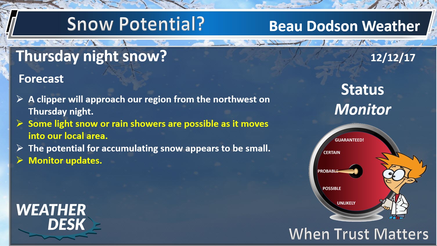
It will remain mostly dry through Thursday night. I can’t rule out some flurries or light snow/rain showers Thursday night and Friday morning.
Small shower chances on Friday and again Saturday/Saturday night. Rainfall totals would be less than 0.10″. Not much, if any.
I am monitoring a larger system for Sunday/Monday.
There is an enhanced fire danger in the region. This is because it has been so dry.
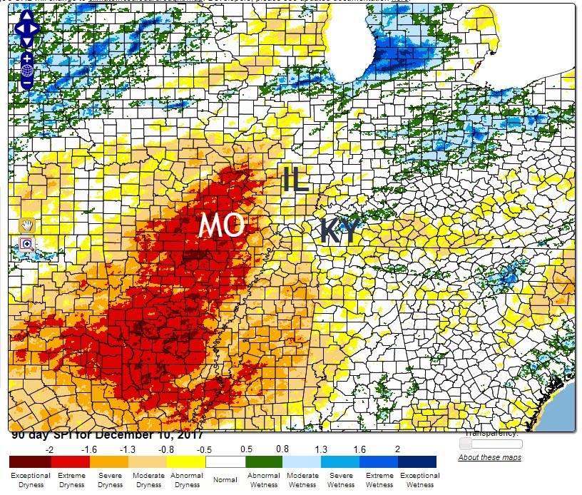
Here is the 90 day SPI index. This shows you how dry it has been across a large chunk of our region.
.
.
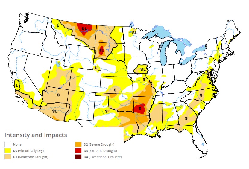
Missouri is being impacted the hardest (locally). Here is the drought monitor map.
.
.
Unfortunately, we don’t have much in the way of precipitation in the forecast through this coming weekend. We have a couple of chances of light rain or snow, but that is about it.
I am monitoring a larger system for Sunday and Monday. Confidence on that precipitation event remains low. Model guidance indicates some potential for rain. I am not overly confident.
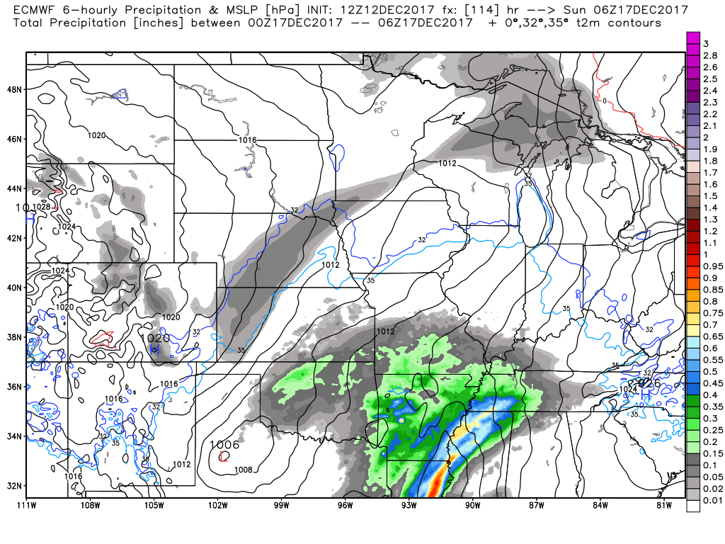
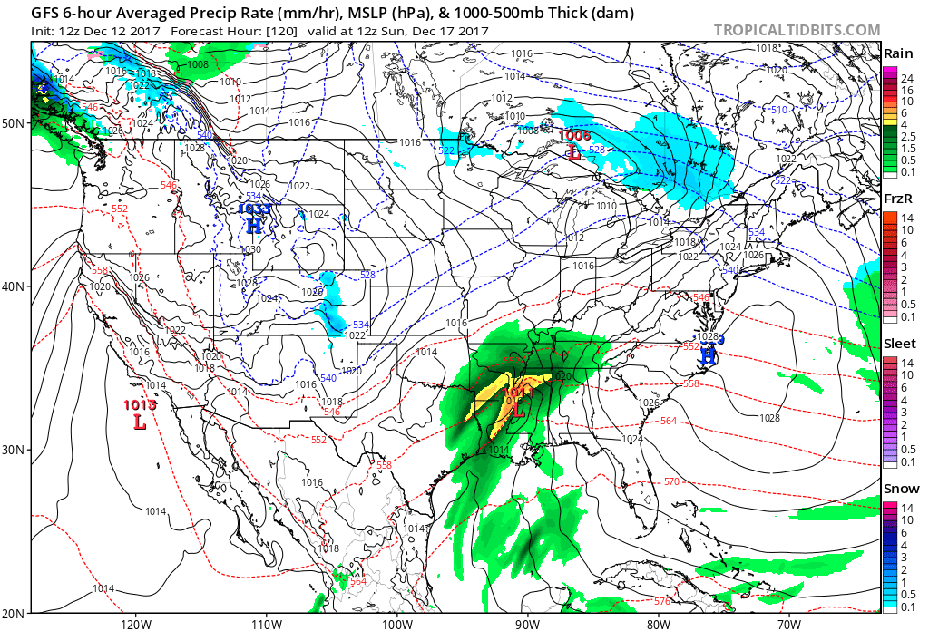
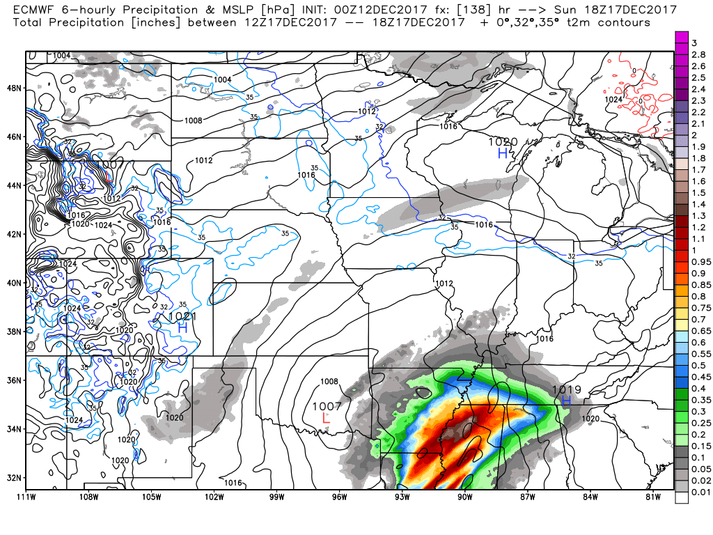
Here is what the EC model guidance is showing for Sunday. The colors represent rain and rain totals. The EC shows heavy rain just to our south.
The system then nudges eastward. That keeps the brunt of the rain out of our region. Again, a bit soon to know for certain. I will monitor trends.
We need rain.
This image is for 1 am on Sunday. You can see rain spreading into our region from the south and southwest.
.
.
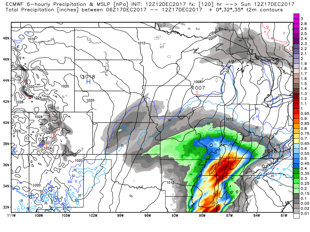
Here is the same model at 6 AM on Sunday.
The EC model guidance paints some locally heavy rain over our southern and southeastern counties.
.
. .
.
.
The GFS model shows rain moving into the area early on Sunday, as well.
Green represents rain.
.
.
Beau’s Winter Weather Outlook
.
.
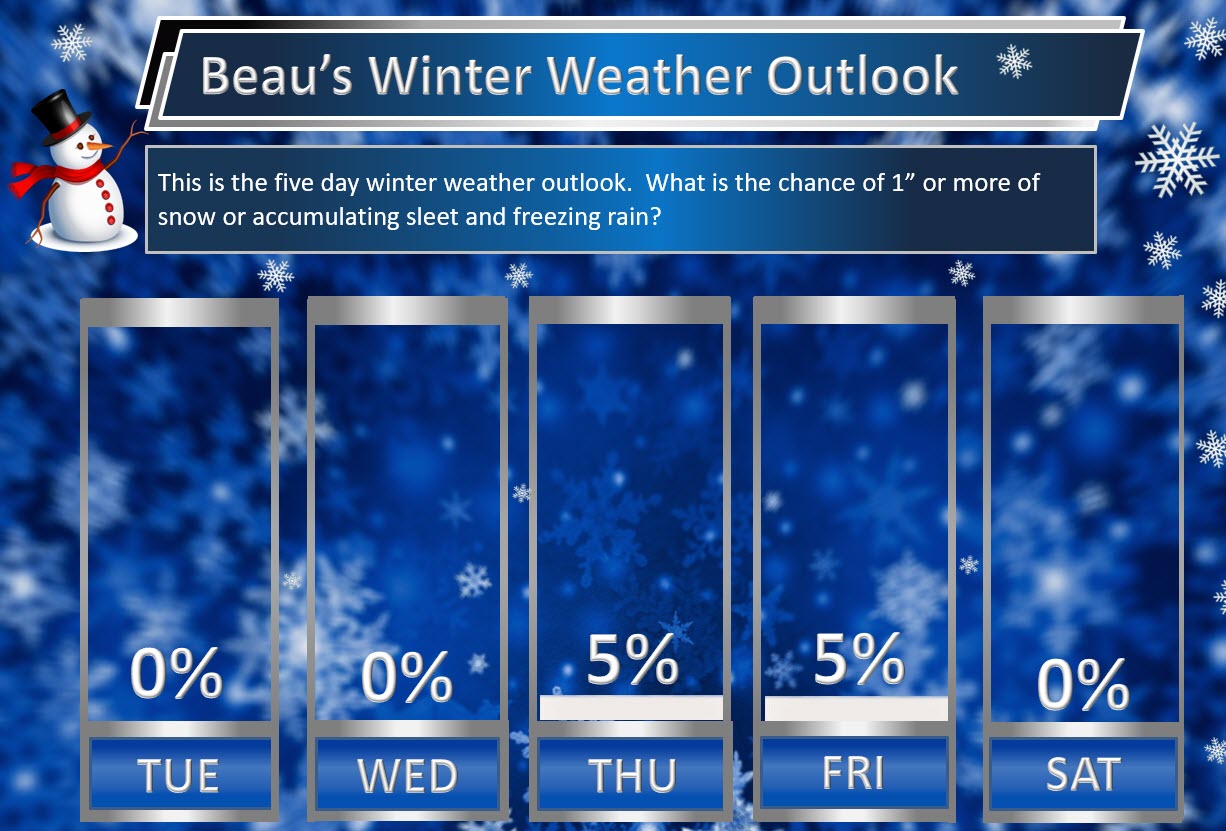
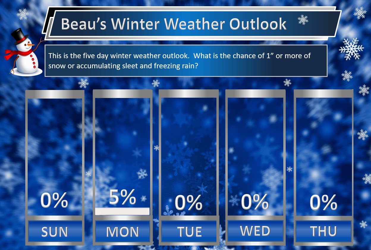
Here is my latest snow probability map for the week ahead.
These graphics show you the % chance of one inch or more of snow and/or accumulating sleet and freezing rain.
A few flurries possible Monday night and Tuesday morning. The chance of one inch or more of snow is zero.
I am monitoring Thursday night and Friday morning for snow showers. The chance of one inch or more of snow is small.
.
.
.
I am closely monitoring a system around the 23rd through the 26th. Confidence is low, because it is so far out in time. Models don’t handle winter forecasts all that great two or three days out.
There is an above normal risk for a storm system between December 23rd and December 26th.
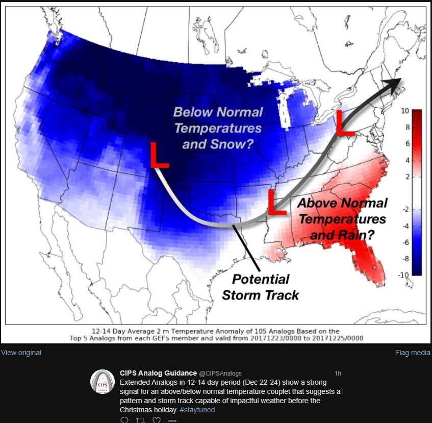
CIPS analogs are showing the potential of a precipitation event in the Central and Eastern United States. CIPS analogs uses past weather events to compare to current weather patterns. It is a useful tool in short and long range forecasting
Click image to enlarge.
This map shows you the temperature forecast for the 22nd through the 24th. Look at the cold air behind a possible storm system. Warm ahead of the system.
Blue indicates the likelihood of below normal temperatures. Red indicates the likelihood of above normal temperatures.
That potentially places us in the middle. Again, this is a long way out.
.
.
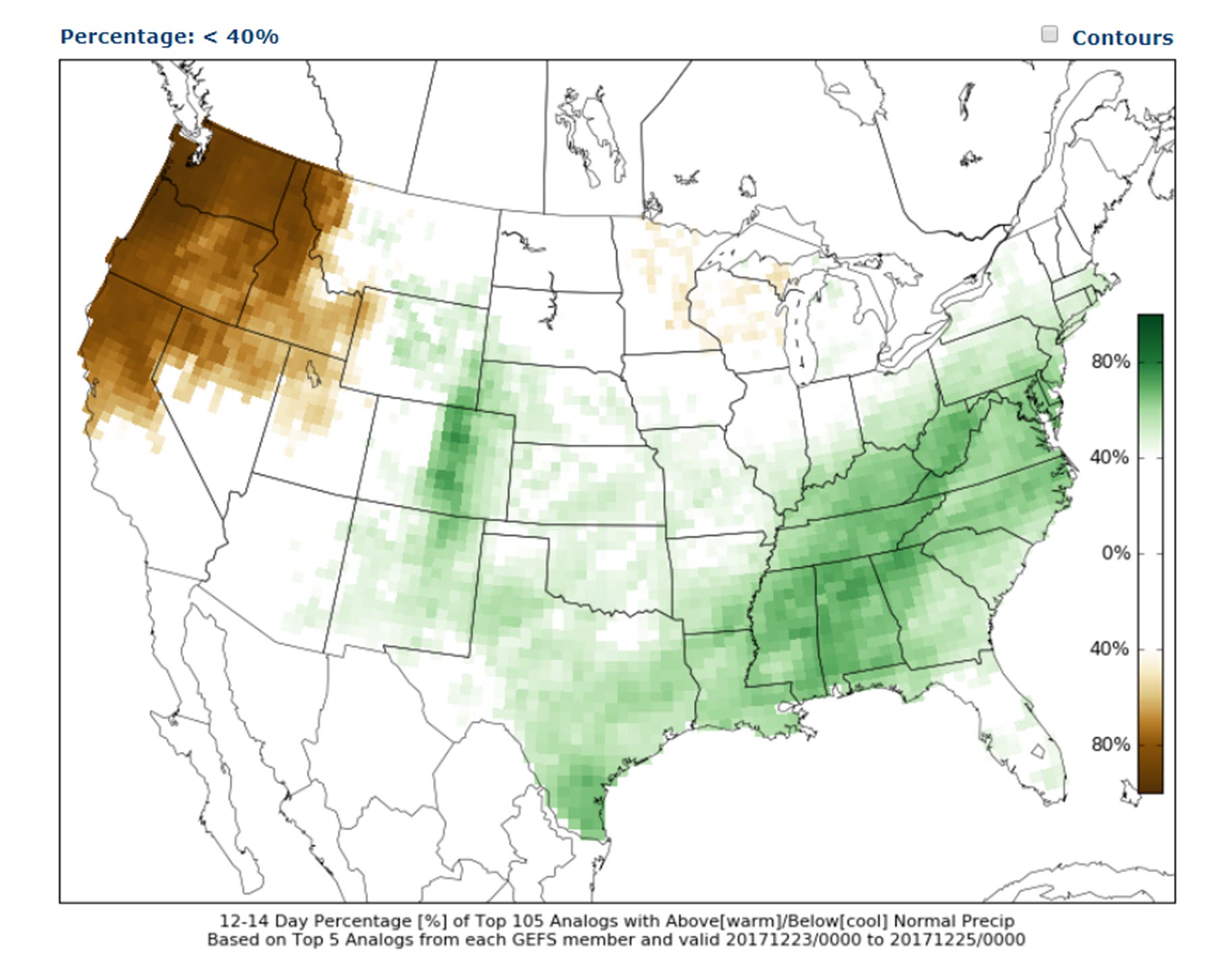
The precipitation outlook indicates the potential for rain or snow. Green represents above normal precipitation potential.
.
. .
.
.
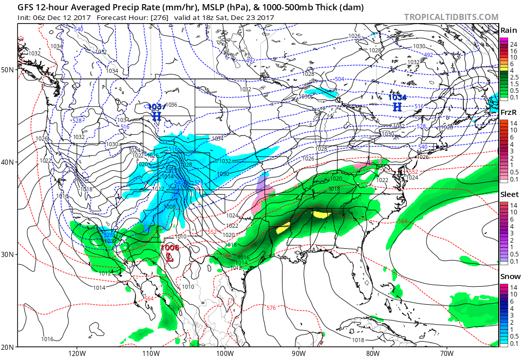
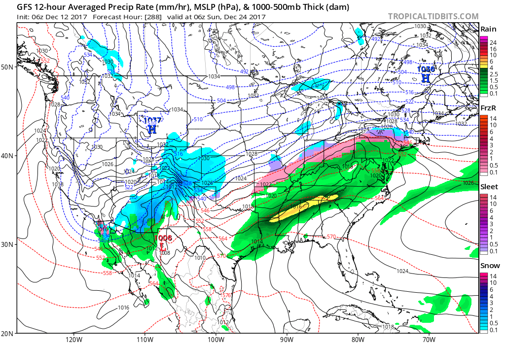
Models are showing precipitation in our region during this time frame. Whether cold air will be in place is the question. Both the GFS and EC guidance indicate the potential for precipitation.
Here is the GFS for the 23rd. You can see green in our region. That would be rain. Again, it is too early to even know if there will be a system. I am just showing you the GFS model guidance.
You can see a system developing. Snow would be the blue colors. Sleet and mixture would be the pink and purple colors. Green represents rain.
There is also a sharp temperature gradient over the region. That is a signal for potential precipitation, as well.
.
.
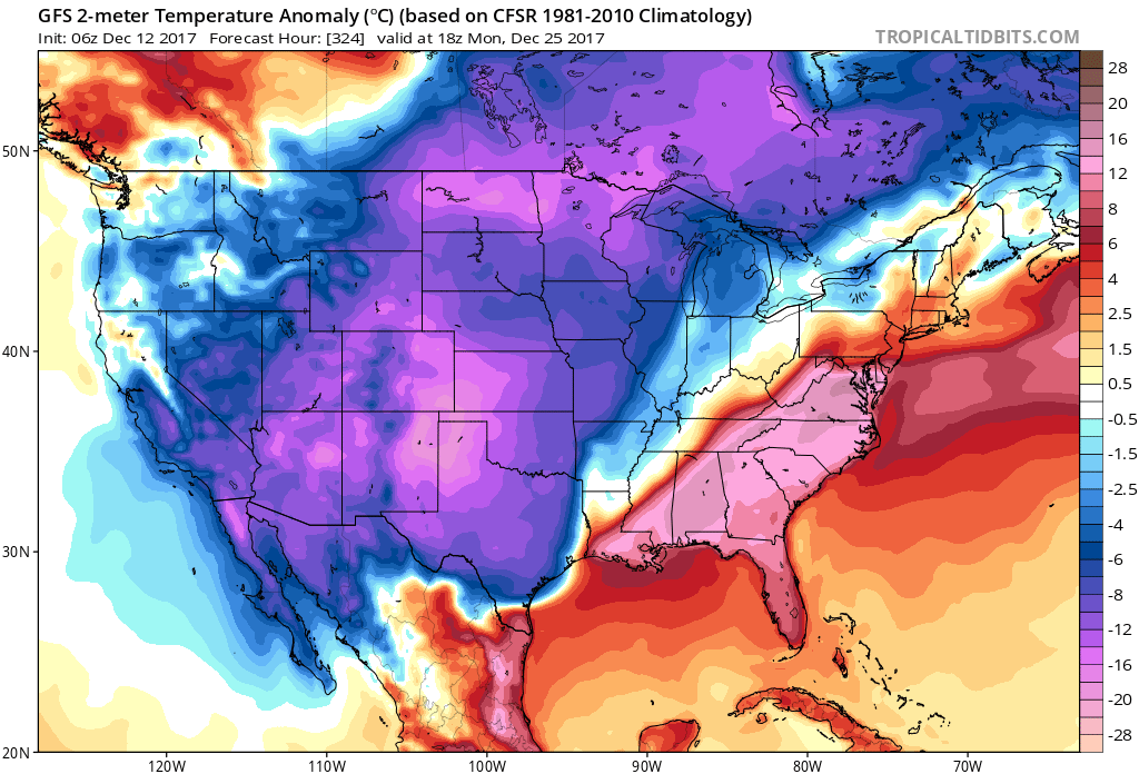
This next image is the temperature anomaly map for December 25th. The blue and purple colors represent well below normal temperatures. The red colors represent above normal temperatures. See the battle ground? Right over our region. This is a signal for a storm system. Long off and much can change.
Click images to enlarge
.
.
This next image is for the night of December 23rd and morning of December 24th. The GFS is showing precipitation in and near our region. Again, this is guidance and not gospel. These models will flip and flop for days to come.
.
.
So what does all of this mean? Not much.
It means we have a possible precipitation event in the long range that may or may not actually verify. There could be cold air in place in or near our region for the precipitation to interact with.
It is just too soon to know if we will have snow/rain/other on or around Christmas.
I will track the potential and update you over the coming days.
.


We offer regional radars and local city radars – if a radar does not update then try another one. Occasional browsers need their cache cleared. You may also try restarting your browser. This will usually fix any problems.
During the winter you can track snow and ice by clicking the winterize button on the local city view interactive radars.
You may email me at beaudodson@usawx.com
Interactive Weather Radar Page. Choose the city nearest your location: Click this link
National interactive radar: Click this link.